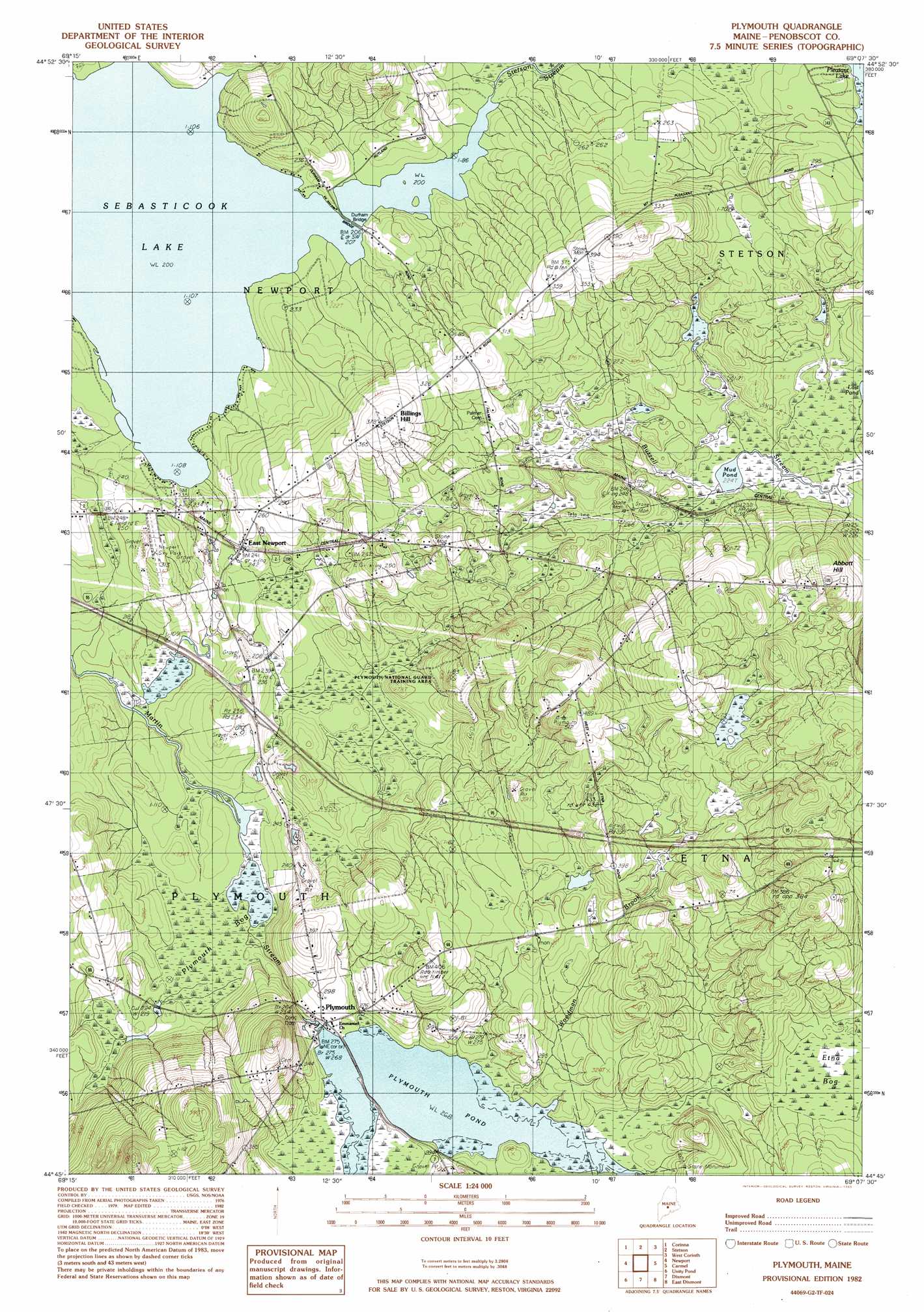
Plymouth Topo Map Maine
To zoom in, hover over the map of Plymouth
USGS Topo Quad 44069g2 - 1:24,000 scale
| Topo Map Name: | Plymouth |
| USGS Topo Quad ID: | 44069g2 |
| Print Size: | ca. 21 1/4" wide x 27" high |
| Southeast Coordinates: | 44.75° N latitude / 69.125° W longitude |
| Map Center Coordinates: | 44.8125° N latitude / 69.1875° W longitude |
| U.S. State: | ME |
| Filename: | o44069g2.jpg |
| Download Map JPG Image: | Plymouth topo map 1:24,000 scale |
| Map Type: | Topographic |
| Topo Series: | 7.5´ |
| Map Scale: | 1:24,000 |
| Source of Map Images: | United States Geological Survey (USGS) |
| Alternate Map Versions: |
Stetson SW ME 1975, updated 1980 Download PDF Buy paper map Plymouth ME 1982, updated 1983 Download PDF Buy paper map Plymouth ME 2011 Download PDF Buy paper map Plymouth ME 2014 Download PDF Buy paper map |
1:24,000 Topo Quads surrounding Plymouth
Cambridge |
Dexter |
Garland |
Charleston |
Bradford |
Hartland |
Corinna |
Stetson |
West Corinth |
Kenduskeag |
Pittsfield |
Newport |
Plymouth |
Carmel |
Hermon |
Burnham |
Unity Pond |
Dixmont |
East Dixmont |
Snow Mountain |
Albion |
Unity |
Brooks West |
Brooks East |
Mount Waldo |
> Back to 44069e1 at 1:100,000 scale
> Back to 44068a1 at 1:250,000 scale
> Back to U.S. Topo Maps home
Plymouth topo map: Gazetteer
Plymouth: Airports
Newport Sky Park elevation 95m 311′Plymouth: Bridges
Durham Bridge elevation 61m 200′Plymouth: Crossings
Interchange 41 elevation 73m 239′Plymouth: Dams
Plymouth Pond Dam elevation 82m 269′Plymouth: Lakes
Mud Pond elevation 68m 223′Plymouth: Populated Places
Billings Hill elevation 114m 374′East Newport elevation 74m 242′
Plymouth elevation 81m 265′
Plymouth: Reservoirs
Plymouth Pond elevation 82m 269′Plymouth: Streams
Stetson Stream elevation 61m 200′Woodman Brook elevation 82m 269′
Plymouth: Summits
Abbott Hill elevation 130m 426′Plymouth: Swamps
Plymouth Bog elevation 68m 223′Plymouth: Trails
Moosehead Trail elevation 74m 242′Plymouth digital topo map on disk
Buy this Plymouth topo map showing relief, roads, GPS coordinates and other geographical features, as a high-resolution digital map file on DVD:
Maine, New Hampshire, Rhode Island & Eastern Massachusetts
Buy digital topo maps: Maine, New Hampshire, Rhode Island & Eastern Massachusetts