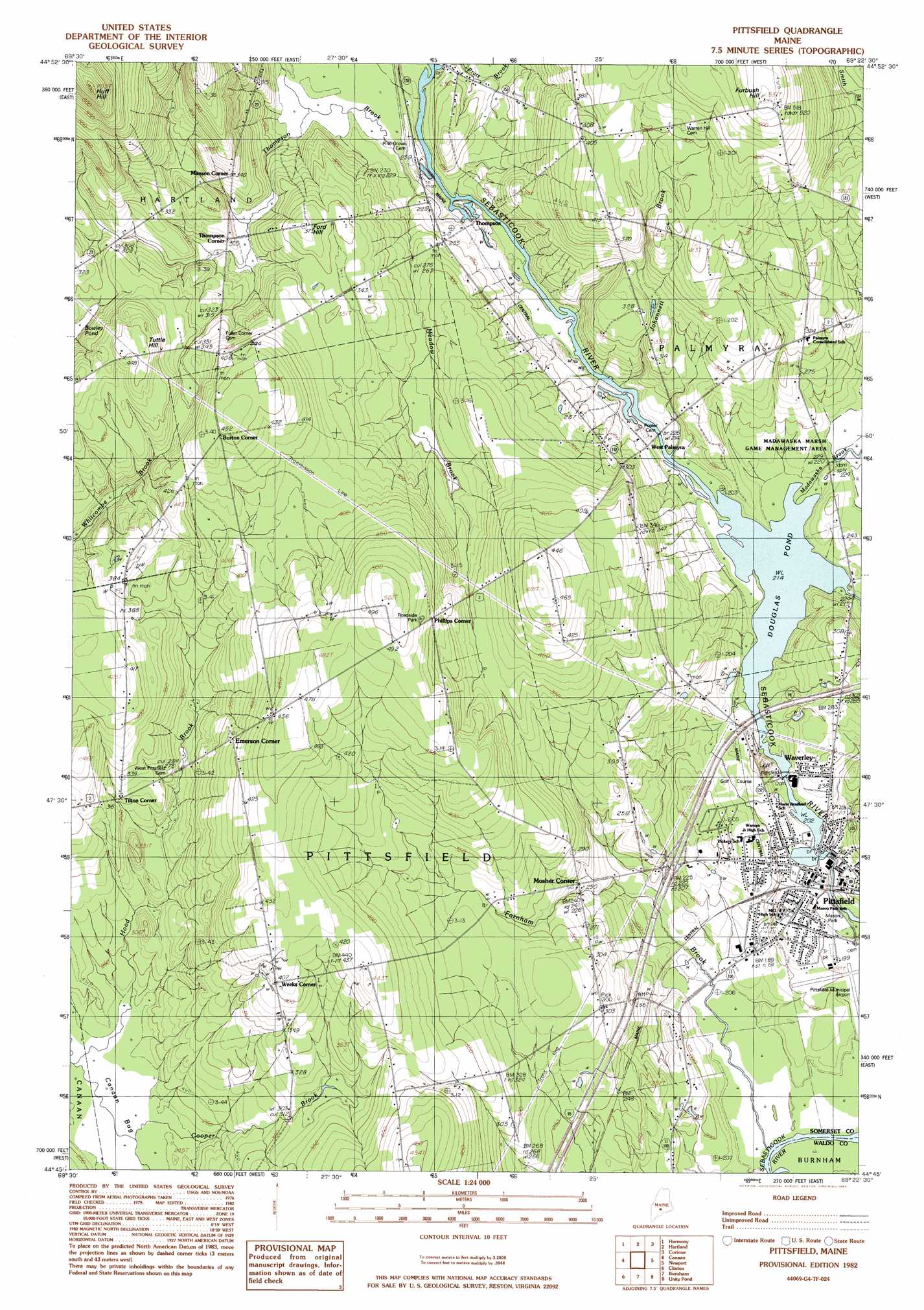
Pittsfield Topo Map Maine
To zoom in, hover over the map of Pittsfield
USGS Topo Quad 44069g4 - 1:24,000 scale
| Topo Map Name: | Pittsfield |
| USGS Topo Quad ID: | 44069g4 |
| Print Size: | ca. 21 1/4" wide x 27" high |
| Southeast Coordinates: | 44.75° N latitude / 69.375° W longitude |
| Map Center Coordinates: | 44.8125° N latitude / 69.4375° W longitude |
| U.S. State: | ME |
| Filename: | o44069g4.jpg |
| Download Map JPG Image: | Pittsfield topo map 1:24,000 scale |
| Map Type: | Topographic |
| Topo Series: | 7.5´ |
| Map Scale: | 1:24,000 |
| Source of Map Images: | United States Geological Survey (USGS) |
| Alternate Map Versions: |
Pittsfield SW ME 1975, updated 1980 Download PDF Buy paper map Pittsfield ME 1982, updated 1983 Download PDF Buy paper map Pittsfield ME 2011 Download PDF Buy paper map Pittsfield ME 2014 Download PDF Buy paper map |
1:24,000 Topo Quads surrounding Pittsfield
Kingsbury |
Wellington |
Cambridge |
Dexter |
Garland |
Arbens |
Harmony |
Hartland |
Corinna |
Stetson |
Skowhegan |
Canaan |
Pittsfield |
Newport |
Plymouth |
Hinckley |
Clinton |
Burnham |
Unity Pond |
Dixmont |
Waterville |
Fairfield |
Albion |
Unity |
Brooks West |
> Back to 44069e1 at 1:100,000 scale
> Back to 44068a1 at 1:250,000 scale
> Back to U.S. Topo Maps home
Pittsfield topo map: Gazetteer
Pittsfield: Airports
Grigons Landing Area elevation 122m 400′Payne Field elevation 106m 347′
Pittsfield: Crossings
Interchange 38 elevation 63m 206′Pittsfield: Dams
Pioneer Dam elevation 62m 203′Upper Dam elevation 62m 203′
Pittsfield: Lakes
Bowley Pond elevation 100m 328′Pittsfield: Parks
Mason Park elevation 56m 183′Pittsfield: Populated Places
Burton Corner elevation 138m 452′Emerson Corner elevation 115m 377′
Manson Corner elevation 106m 347′
Mosher Corner elevation 76m 249′
Phillips Corner elevation 137m 449′
Pittsfield elevation 64m 209′
Thompson elevation 70m 229′
Thompson Corner elevation 92m 301′
Tilton Corner elevation 96m 314′
Waverley elevation 75m 246′
Weeks Corner elevation 125m 410′
West Palmyra elevation 72m 236′
Pittsfield: Reservoirs
Douglas Pond elevation 65m 213′Mill Pond elevation 62m 203′
Sebasticook River Reservoir elevation 66m 216′
Pittsfield: Streams
Farnham Brook elevation 50m 164′Fogg Brook elevation 65m 213′
Hood Brook elevation 72m 236′
Indian Stream elevation 66m 216′
Johonnett Brook elevation 67m 219′
Madawaska Brook elevation 65m 213′
Meadow Brook elevation 66m 216′
South Bog Stream elevation 72m 236′
Thompson Brook elevation 67m 219′
Pittsfield: Summits
Ford Hill elevation 113m 370′Furbush Hill elevation 161m 528′
Huff Hill elevation 211m 692′
Negro Hill elevation 130m 426′
Tuttle Hill elevation 138m 452′
Pittsfield digital topo map on disk
Buy this Pittsfield topo map showing relief, roads, GPS coordinates and other geographical features, as a high-resolution digital map file on DVD:
Maine, New Hampshire, Rhode Island & Eastern Massachusetts
Buy digital topo maps: Maine, New Hampshire, Rhode Island & Eastern Massachusetts