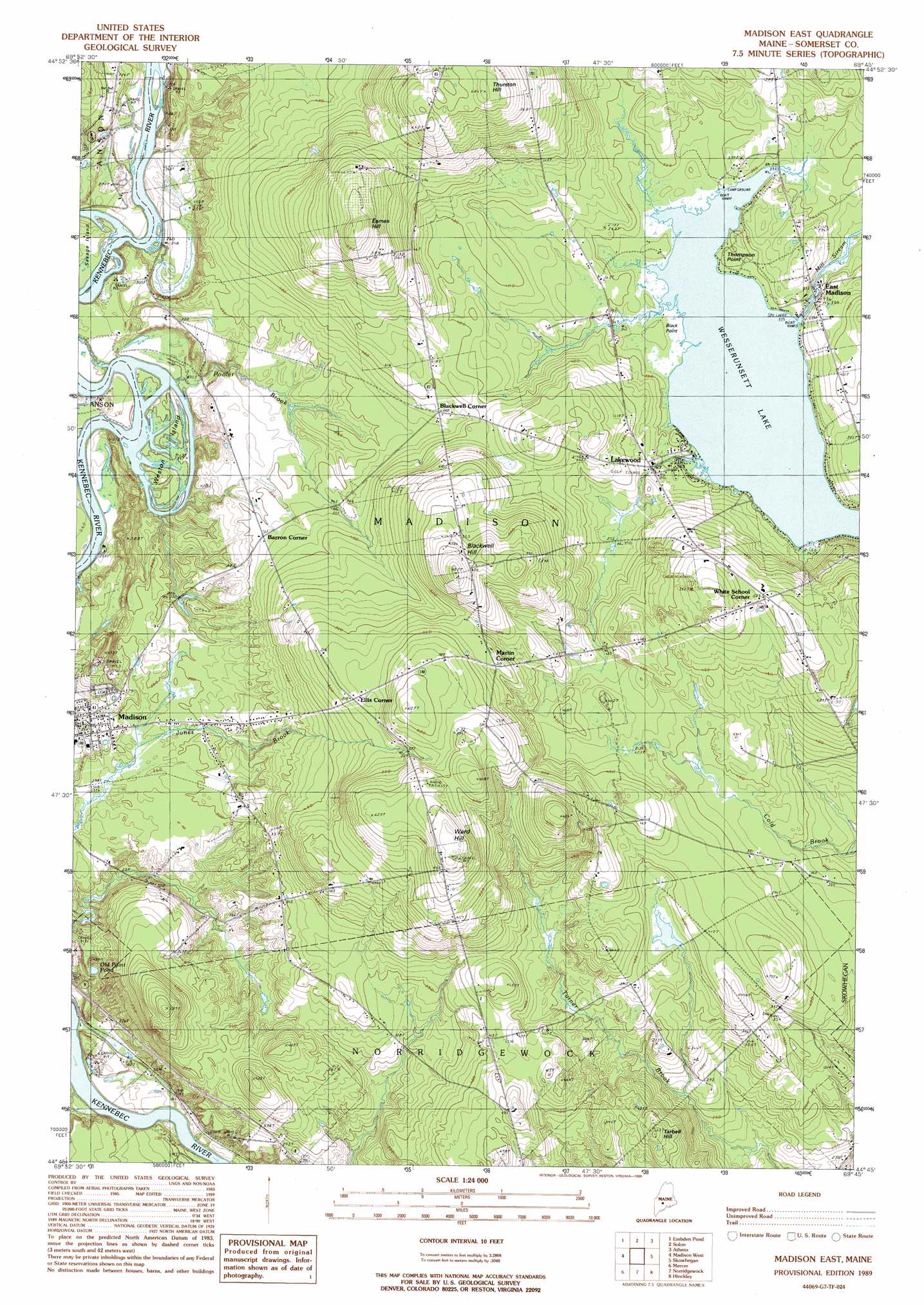
Madison East Topo Map Maine
To zoom in, hover over the map of Madison East
USGS Topo Quad 44069g7 - 1:24,000 scale
| Topo Map Name: | Madison East |
| USGS Topo Quad ID: | 44069g7 |
| Print Size: | ca. 21 1/4" wide x 27" high |
| Southeast Coordinates: | 44.75° N latitude / 69.75° W longitude |
| Map Center Coordinates: | 44.8125° N latitude / 69.8125° W longitude |
| U.S. State: | ME |
| Filename: | o44069g7.jpg |
| Download Map JPG Image: | Madison East topo map 1:24,000 scale |
| Map Type: | Topographic |
| Topo Series: | 7.5´ |
| Map Scale: | 1:24,000 |
| Source of Map Images: | United States Geological Survey (USGS) |
| Alternate Map Versions: |
Anson SE ME 1975, updated 1980 Download PDF Buy paper map Madison East ME 1989, updated 1989 Download PDF Buy paper map Madison East ME 2011 Download PDF Buy paper map Madison East ME 2014 Download PDF Buy paper map |
1:24,000 Topo Quads surrounding Madison East
Witham Mountain |
Bingham |
Mahoney Hill |
Kingsbury |
Wellington |
New Portland |
Embden Pond |
Solon |
Arbens |
Harmony |
New Vineyard |
Madison West |
Madison East |
Skowhegan |
Canaan |
New Sharon |
Mercer |
Norridgewock |
Hinckley |
Clinton |
Farmington Falls |
Belgrade Lakes |
Rome |
Waterville |
Fairfield |
> Back to 44069e1 at 1:100,000 scale
> Back to 44068a1 at 1:250,000 scale
> Back to U.S. Topo Maps home
Madison East topo map: Gazetteer
Madison East: Airports
Wesserunsett and Ice Seaplane Base elevation 102m 334′Madison East: Capes
Black Point elevation 102m 334′Thompson Point elevation 106m 347′
Madison East: Dams
East Madison Dam elevation 100m 328′Madison East: Islands
Weston Island elevation 76m 249′Madison East: Lakes
Old Point Pond elevation 85m 278′Madison East: Populated Places
Barron Corner elevation 110m 360′Blackwell Corner elevation 117m 383′
East Madison elevation 100m 328′
Ellis Corner elevation 158m 518′
Lakewood elevation 104m 341′
Martin Corner elevation 158m 518′
White School Corner elevation 154m 505′
Madison East: Reservoirs
Wesserunsett Lake elevation 104m 341′Madison East: Streams
Pooler Brook elevation 77m 252′Madison East: Summits
Blackwell Hill elevation 199m 652′Eames Hill elevation 211m 692′
Tarbell Hill elevation 137m 449′
Thurston Hill elevation 207m 679′
Ward Hill elevation 206m 675′
Madison East digital topo map on disk
Buy this Madison East topo map showing relief, roads, GPS coordinates and other geographical features, as a high-resolution digital map file on DVD:
Maine, New Hampshire, Rhode Island & Eastern Massachusetts
Buy digital topo maps: Maine, New Hampshire, Rhode Island & Eastern Massachusetts