Arbens Topo Map Maine
To zoom in, hover over the map of Arbens
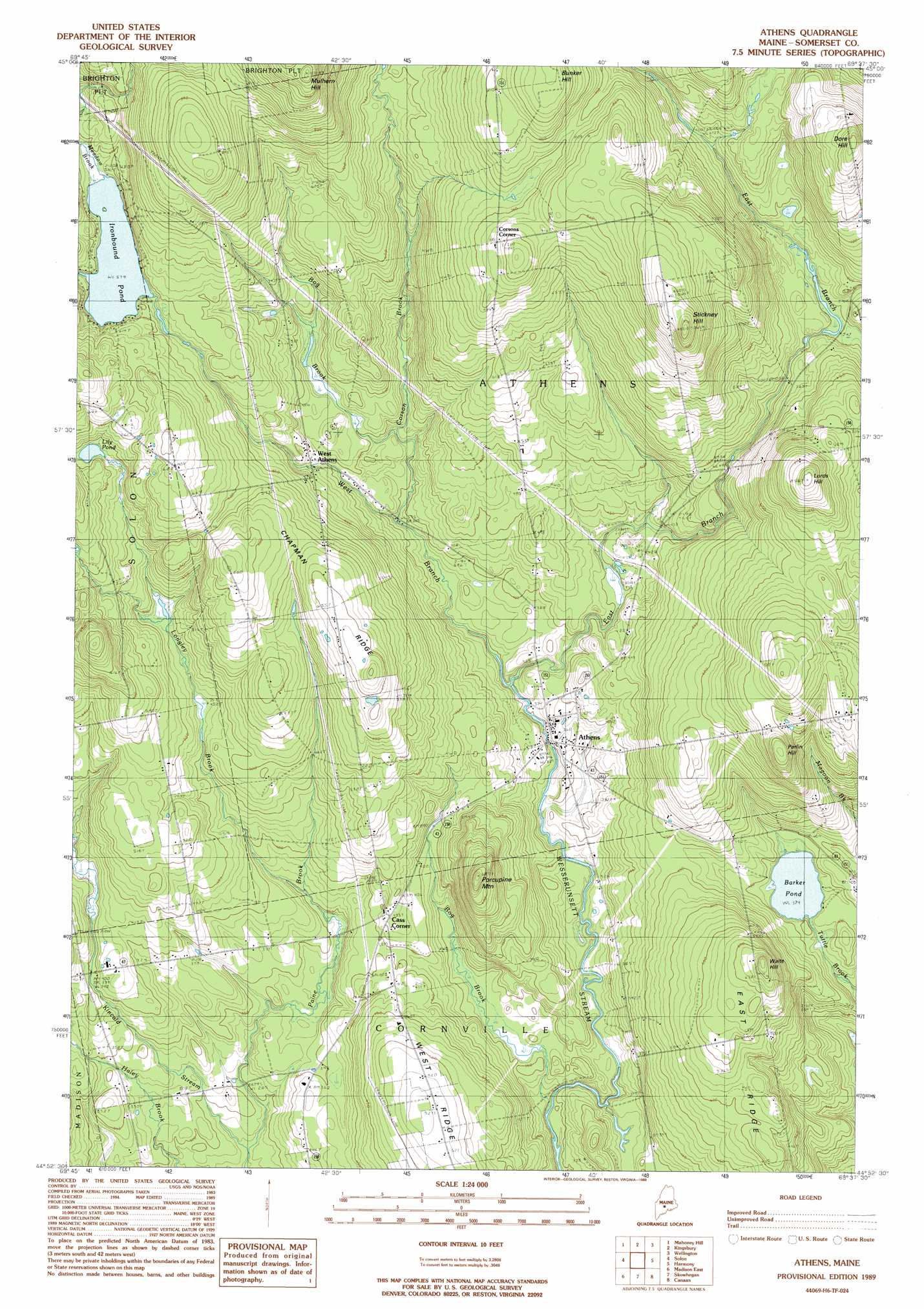
USGS Topo Quad 44069h6 - 1:24,000 scale
| Topo Map Name: | Arbens |
| USGS Topo Quad ID: | 44069h6 |
| Print Size: | ca. 21 1/4" wide x 27" high |
| Southeast Coordinates: | 44.875° N latitude / 69.625° W longitude |
| Map Center Coordinates: | 44.9375° N latitude / 69.6875° W longitude |
| U.S. State: | ME |
| Filename: | o44069h6.jpg |
| Download Map JPG Image: | Arbens topo map 1:24,000 scale |
| Map Type: | Topographic |
| Topo Series: | 7.5´ |
| Map Scale: | 1:24,000 |
| Source of Map Images: | United States Geological Survey (USGS) |
| Alternate Map Versions: |
Skowhegan NW ME 1975, updated 1980 Download PDF Buy paper map Athens ME 1989, updated 1989 Download PDF Buy paper map Athens ME 2011 Download PDF Buy paper map Athens ME 2014 Download PDF Buy paper map |
1:24,000 Topo Quads surrounding Arbens
Caratunk |
Dimmick Mountain |
Foster Ridge |
Whetstone Pond |
Guilford |
Bingham |
Mahoney Hill |
Kingsbury |
Wellington |
Cambridge |
Embden Pond |
Solon |
Arbens |
Harmony |
Hartland |
Madison West |
Madison East |
Skowhegan |
Canaan |
Pittsfield |
Mercer |
Norridgewock |
Hinckley |
Clinton |
Burnham |
> Back to 44069e1 at 1:100,000 scale
> Back to 44068a1 at 1:250,000 scale
> Back to U.S. Topo Maps home
Arbens topo map: Gazetteer
Arbens: Lakes
Barker Pond elevation 115m 377′Ironbound Pond elevation 176m 577′
Lily Pond elevation 178m 583′
Arbens: Populated Places
Athens elevation 106m 347′Cass Corner elevation 131m 429′
Corsons Corner elevation 242m 793′
West Athens elevation 146m 479′
Arbens: Ridges
Chapman Ridge elevation 199m 652′Arbens: Streams
Bog Brook elevation 127m 416′Bog Brook elevation 89m 291′
Corson Brook elevation 115m 377′
East Branch Wesserunsett Stream elevation 105m 344′
Longley Brook elevation 106m 347′
Meadow Brook elevation 179m 587′
Paine Brook elevation 82m 269′
West Branch Wesserunsett Stream elevation 105m 344′
Arbens: Summits
Bunker Hill elevation 272m 892′Lords Hill elevation 258m 846′
Mulhern Hill elevation 309m 1013′
Parlin Hill elevation 232m 761′
Porcupine Mountain elevation 199m 652′
Stickney Hill elevation 284m 931′
Waite Hill elevation 199m 652′
Arbens digital topo map on disk
Buy this Arbens topo map showing relief, roads, GPS coordinates and other geographical features, as a high-resolution digital map file on DVD:
Maine, New Hampshire, Rhode Island & Eastern Massachusetts
Buy digital topo maps: Maine, New Hampshire, Rhode Island & Eastern Massachusetts