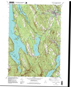
Mechanic Falls Topo Map Maine
To zoom in, hover over the map of Mechanic Falls
USGS Topo Quad 44070a4 - 1:24,000 scale
| Topo Map Name: | Mechanic Falls |
| USGS Topo Quad ID: | 44070a4 |
| Print Size: | ca. 21 1/4" wide x 27" high |
| Southeast Coordinates: | 44° N latitude / 70.375° W longitude |
| Map Center Coordinates: | 44.0625° N latitude / 70.4375° W longitude |
| U.S. State: | ME |
| Filename: | o44070a4.jpg |
| Download Map JPG Image: | Mechanic Falls topo map 1:24,000 scale |
| Map Type: | Topographic |
| Topo Series: | 7.5´ |
| Map Scale: | 1:24,000 |
| Source of Map Images: | United States Geological Survey (USGS) |
| Alternate Map Versions: |
Mechanic Falls ME 1981, updated 1981 Download PDF Buy paper map Mechanic Falls ME 1995, updated 1999 Download PDF Buy paper map Mechanic Falls ME 2011 Download PDF Buy paper map Mechanic Falls ME 2014 Download PDF Buy paper map |
1:24,000 Topo Quads surrounding Mechanic Falls
> Back to 44070a1 at 1:100,000 scale
> Back to 44070a1 at 1:250,000 scale
> Back to U.S. Topo Maps home
Mechanic Falls topo map: Gazetteer
Mechanic Falls: Bays
Edwards Cove elevation 99m 324′Haynes Cove elevation 99m 324′
Potash Cove elevation 99m 324′
Mechanic Falls: Capes
Abrams Point elevation 102m 334′Hayes Point elevation 107m 351′
Lunt Point elevation 103m 337′
Parsons Point elevation 100m 328′
Pine Point elevation 131m 429′
The Bar elevation 101m 331′
Mechanic Falls: Dams
Estes Bog Dam elevation 118m 387′Mechanic Falls Dam elevation 80m 262′
Waterhouse Brook Dam elevation 87m 285′
Mechanic Falls: Islands
Birch Island elevation 99m 324′Black Island elevation 104m 341′
Crescent Island elevation 99m 324′
Heath Island elevation 116m 380′
Megquier Island elevation 105m 344′
Squirrel Island elevation 104m 341′
Turtle Island elevation 100m 328′
Wacipi Island elevation 99m 324′
Mechanic Falls: Lakes
Estes Bog elevation 121m 396′Frog Pond elevation 105m 344′
Green Pond elevation 93m 305′
Hogan Pond elevation 92m 301′
Middle Range Pond elevation 93m 305′
Mud Pond elevation 93m 305′
Mud Pond elevation 93m 305′
Tripp Pond elevation 93m 305′
Upper Range Pond elevation 93m 305′
Whitney Pond elevation 92m 301′
Mechanic Falls: Parks
Range Ponds State Park elevation 105m 344′Mechanic Falls: Populated Places
Five Corners elevation 95m 311′Mechanic Falls elevation 84m 275′
Oak Hill elevation 181m 593′
Poland elevation 101m 331′
Promised Land elevation 126m 413′
West Poland elevation 109m 357′
Mechanic Falls: Reservoirs
Little Androscoggin River Reservoir elevation 78m 255′Lower Range Pond elevation 87m 285′
Middle Range Pond elevation 122m 400′
Mechanic Falls: Streams
Cousins Brook elevation 85m 278′Jerry Brook elevation 99m 324′
May Brook elevation 93m 305′
Meadow Brook elevation 93m 305′
Potash Brook elevation 99m 324′
Waterhouse Brook elevation 83m 272′
Wilson Brook elevation 93m 305′
Mechanic Falls: Summits
Black Cat Mountain elevation 250m 820′Dean Hill elevation 150m 492′
Johnson Hill elevation 237m 777′
Megquier Hill elevation 162m 531′
Oak Hill elevation 184m 603′
Pigeon Hill elevation 193m 633′
Range Hill elevation 178m 583′
Raspberry Hill elevation 165m 541′
Tiger Hill elevation 141m 462′
White Oak Hill elevation 205m 672′
Mechanic Falls: Swamps
The Heath elevation 99m 324′Mechanic Falls digital topo map on disk
Buy this Mechanic Falls topo map showing relief, roads, GPS coordinates and other geographical features, as a high-resolution digital map file on DVD:
Maine, New Hampshire, Rhode Island & Eastern Massachusetts
Buy digital topo maps: Maine, New Hampshire, Rhode Island & Eastern Massachusetts


