Lake Auburn West Topo Map Maine
To zoom in, hover over the map of Lake Auburn West
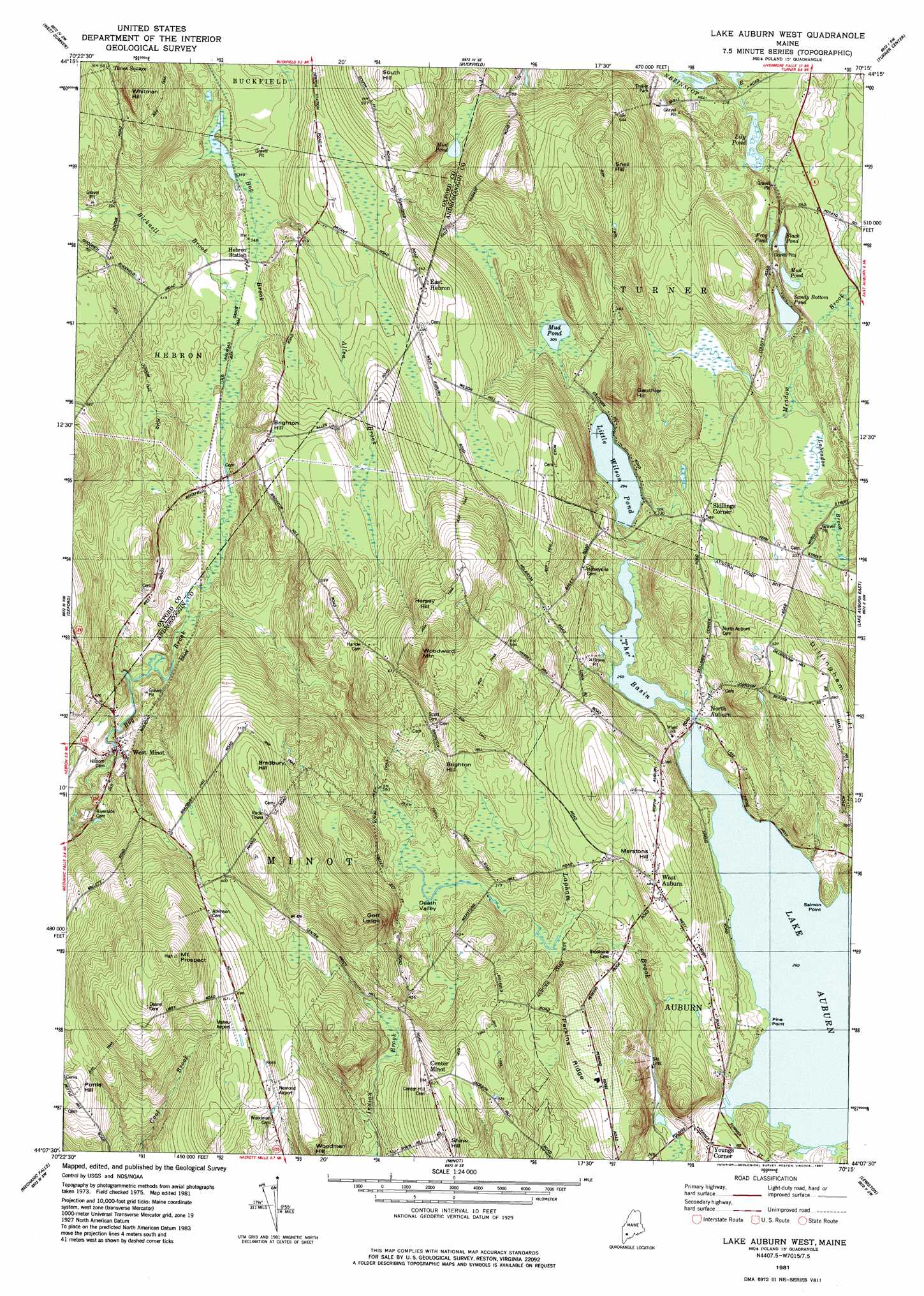
USGS Topo Quad 44070b3 - 1:24,000 scale
| Topo Map Name: | Lake Auburn West |
| USGS Topo Quad ID: | 44070b3 |
| Print Size: | ca. 21 1/4" wide x 27" high |
| Southeast Coordinates: | 44.125° N latitude / 70.25° W longitude |
| Map Center Coordinates: | 44.1875° N latitude / 70.3125° W longitude |
| U.S. State: | ME |
| Filename: | o44070b3.jpg |
| Download Map JPG Image: | Lake Auburn West topo map 1:24,000 scale |
| Map Type: | Topographic |
| Topo Series: | 7.5´ |
| Map Scale: | 1:24,000 |
| Source of Map Images: | United States Geological Survey (USGS) |
| Alternate Map Versions: |
Lake Auburn West ME 1981, updated 1981 Download PDF Buy paper map Lake Auburn West ME 1981, updated 1981 Download PDF Buy paper map Lake Auburn West ME 2011 Download PDF Buy paper map Lake Auburn West ME 2014 Download PDF Buy paper map |
1:24,000 Topo Quads surrounding Lake Auburn West
Mount Zircon |
Worthley Pond |
Canton |
Livermore Falls |
Fayette |
West Paris |
West Sumner |
Buckfield |
Turner Center |
Wayne |
Norway |
Oxford |
Lake Auburn West |
Lake Auburn East |
Monmouth |
Casco |
Mechanic Falls |
Minot |
Lewiston |
Lisbon Falls North |
Naples |
Raymond |
Gray |
North Pownal |
Lisbon Falls South |
> Back to 44070a1 at 1:100,000 scale
> Back to 44070a1 at 1:250,000 scale
> Back to U.S. Topo Maps home
Lake Auburn West topo map: Gazetteer
Lake Auburn West: Airports
Hemond Airport elevation 198m 649′Maheu Airport elevation 214m 702′
Lake Auburn West: Basins
Death Valley elevation 108m 354′Lake Auburn West: Capes
Pine Point elevation 80m 262′Salmon Point elevation 79m 259′
Lake Auburn West: Dams
North Auburn Dam elevation 82m 269′Lake Auburn West: Lakes
Black Pond elevation 98m 321′Frog Pond elevation 101m 331′
Lily Pond elevation 96m 314′
Little Wilson Pond elevation 89m 291′
Mud Pond elevation 93m 305′
Mud Pond elevation 97m 318′
Mud Pond elevation 120m 393′
Sandy Bottom Pond elevation 97m 318′
Lake Auburn West: Populated Places
Center Minot elevation 188m 616′East Hebron elevation 166m 544′
North Auburn elevation 86m 282′
Skillings Corner elevation 121m 396′
West Auburn elevation 146m 479′
West Minot elevation 99m 324′
Youngs Corner elevation 91m 298′
Lake Auburn West: Reservoirs
The Basin elevation 82m 269′Lake Auburn West: Ridges
Perkins Ridge elevation 153m 501′Lake Auburn West: Streams
Allen Brook elevation 105m 344′Bicknell Brook elevation 104m 341′
Lake Auburn West: Summits
Bradbury Hill elevation 232m 761′Brighton Hill elevation 150m 492′
Dillingham Hill elevation 177m 580′
Gauthier Hill elevation 150m 492′
Goff Ledge elevation 233m 764′
Hersey Hill elevation 238m 780′
Marstons Hill elevation 145m 475′
Mount Prospect elevation 280m 918′
Pottle Hill elevation 198m 649′
Shaw Hill elevation 195m 639′
Snell Hill elevation 206m 675′
South Hill elevation 195m 639′
Whitman Hill elevation 204m 669′
Woodman Hill elevation 214m 702′
Woodward Mountain elevation 198m 649′
Lake Auburn West digital topo map on disk
Buy this Lake Auburn West topo map showing relief, roads, GPS coordinates and other geographical features, as a high-resolution digital map file on DVD:
Maine, New Hampshire, Rhode Island & Eastern Massachusetts
Buy digital topo maps: Maine, New Hampshire, Rhode Island & Eastern Massachusetts