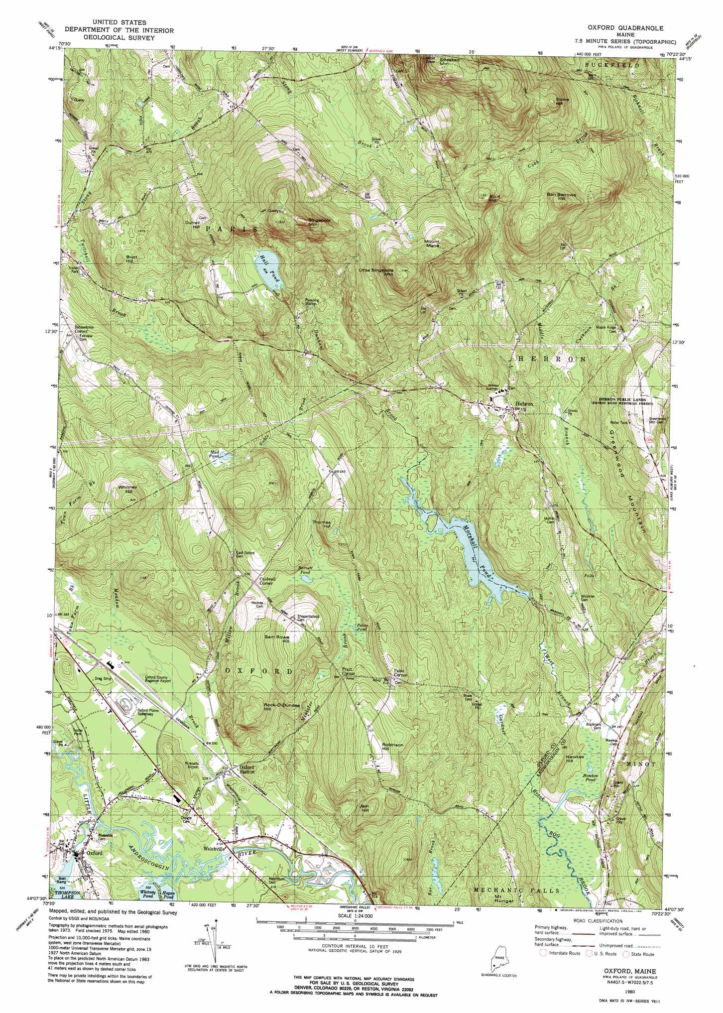
Oxford Topo Map Maine
To zoom in, hover over the map of Oxford
USGS Topo Quad 44070b4 - 1:24,000 scale
| Topo Map Name: | Oxford |
| USGS Topo Quad ID: | 44070b4 |
| Print Size: | ca. 21 1/4" wide x 27" high |
| Southeast Coordinates: | 44.125° N latitude / 70.375° W longitude |
| Map Center Coordinates: | 44.1875° N latitude / 70.4375° W longitude |
| U.S. State: | ME |
| Filename: | o44070b4.jpg |
| Download Map JPG Image: | Oxford topo map 1:24,000 scale |
| Map Type: | Topographic |
| Topo Series: | 7.5´ |
| Map Scale: | 1:24,000 |
| Source of Map Images: | United States Geological Survey (USGS) |
| Alternate Map Versions: |
Oxford ME 1980, updated 1981 Download PDF Buy paper map Oxford ME 1980, updated 1981 Download PDF Buy paper map Oxford ME 2011 Download PDF Buy paper map Oxford ME 2014 Download PDF Buy paper map |
1:24,000 Topo Quads surrounding Oxford
Bryant Pond |
Mount Zircon |
Worthley Pond |
Canton |
Livermore Falls |
Greenwood |
West Paris |
West Sumner |
Buckfield |
Turner Center |
Ralph |
Norway |
Oxford |
Lake Auburn West |
Lake Auburn East |
Bridgton |
Casco |
Mechanic Falls |
Minot |
Lewiston |
North Sebago |
Naples |
Raymond |
Gray |
North Pownal |
> Back to 44070a1 at 1:100,000 scale
> Back to 44070a1 at 1:250,000 scale
> Back to U.S. Topo Maps home
Oxford topo map: Gazetteer
Oxford: Airports
Kimballs Airport elevation 99m 324′Oxford County Regional Airport elevation 103m 337′
Oxford: Dams
Hall Pond Dam elevation 254m 833′Marshall Pond Dam elevation 100m 328′
Thompson Lake Dam elevation 99m 324′
Welchville Dam elevation 91m 298′
Oxford: Forests
Hebron Public Lands elevation 176m 577′Oxford: Lakes
Barnett Pond elevation 163m 534′Hawkes Pond elevation 75m 246′
Hawkes Pond elevation 75m 246′
Mud Pond elevation 206m 675′
Oxford: Parks
Oxford Plains Speedway elevation 106m 347′Oxford: Populated Places
Brimstone Corner elevation 203m 666′Caldwell Corner elevation 167m 547′
Hebron elevation 174m 570′
Oxford elevation 100m 328′
Oxford Station elevation 102m 334′
Paine Corner elevation 187m 613′
Pratt Corner elevation 179m 587′
Welchville elevation 95m 311′
Oxford: Reservoirs
Hall Pond elevation 254m 833′Little Androscoggin River Reservoir elevation 91m 298′
Marshall Pond elevation 100m 328′
Thompson Lake elevation 99m 324′
Oxford: Streams
Cobb Brook elevation 149m 488′Cushman Brook elevation 118m 387′
Dunham Brook elevation 105m 344′
Gardner Brook elevation 74m 242′
Meadow Brook elevation 91m 298′
Middle Branch Bog Brook elevation 75m 246′
Minister Brook elevation 89m 291′
Noble Brook elevation 123m 403′
Twitchell Brook elevation 121m 396′
West Branch Bog Brook elevation 75m 246′
Willow Brook elevation 100m 328′
Oxford: Summits
Ben Barrows Hill elevation 341m 1118′Brett Hill elevation 197m 646′
Durrell Hill elevation 295m 967′
Greenwood Mountain elevation 232m 761′
Hawkes Hill elevation 116m 380′
Jam Hill elevation 195m 639′
Little Singepole Mountain elevation 414m 1358′
Mount Hunger elevation 160m 524′
Mount Marie elevation 378m 1240′
Number 4 Hill elevation 346m 1135′
Robinson Hill elevation 229m 751′
Rock-O-Dundee Hill elevation 192m 629′
Sam Rowe Hill elevation 222m 728′
Singepole Mountain elevation 424m 1391′
Stone Hill elevation 361m 1184′
Streaked Mountain elevation 512m 1679′
Thomas Hill elevation 228m 748′
Whitney Hill elevation 250m 820′
Oxford digital topo map on disk
Buy this Oxford topo map showing relief, roads, GPS coordinates and other geographical features, as a high-resolution digital map file on DVD:
Maine, New Hampshire, Rhode Island & Eastern Massachusetts
Buy digital topo maps: Maine, New Hampshire, Rhode Island & Eastern Massachusetts