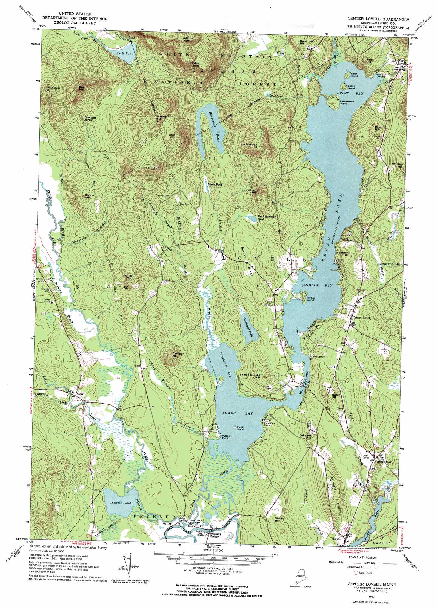
Center Lovell Topo Map Maine
To zoom in, hover over the map of Center Lovell
USGS Topo Quad 44070b8 - 1:24,000 scale
| Topo Map Name: | Center Lovell |
| USGS Topo Quad ID: | 44070b8 |
| Print Size: | ca. 21 1/4" wide x 27" high |
| Southeast Coordinates: | 44.125° N latitude / 70.875° W longitude |
| Map Center Coordinates: | 44.1875° N latitude / 70.9375° W longitude |
| U.S. State: | ME |
| Filename: | o44070b8.jpg |
| Download Map JPG Image: | Center Lovell topo map 1:24,000 scale |
| Map Type: | Topographic |
| Topo Series: | 7.5´ |
| Map Scale: | 1:24,000 |
| Source of Map Images: | United States Geological Survey (USGS) |
| Alternate Map Versions: |
Center Lovell ME 1963, updated 1965 Download PDF Buy paper map Center Lovell ME 1963, updated 1965 Download PDF Buy paper map Center Lovell ME 1995, updated 2000 Download PDF Buy paper map Center Lovell ME 2012 Download PDF Buy paper map Center Lovell ME 2014 Download PDF Buy paper map |
| FStopo: | US Forest Service topo Center Lovell is available: Download FStopo PDF Download FStopo TIF |
1:24,000 Topo Quads surrounding Center Lovell
Berlin |
Shelburne |
Gilead |
Bethel |
Bryant Pond |
Carter Dome |
Wild River |
Speckled Mountain |
East Stoneham |
Greenwood |
Jackson |
Chatham |
Center Lovell |
North Waterford |
Ralph |
North Conway West |
North Conway East |
Fryeburg |
Pleasant Mountain |
Bridgton |
Silver Lake |
Conway |
Brownfield |
Hiram |
North Sebago |
> Back to 44070a1 at 1:100,000 scale
> Back to 44070a1 at 1:250,000 scale
> Back to U.S. Topo Maps home
Center Lovell topo map: Gazetteer
Center Lovell: Bays
Fryeburg Harbor elevation 116m 380′Lower Bay elevation 115m 377′
Middle Bay elevation 115m 377′
Northwest Cove elevation 115m 377′
Upper Bay elevation 115m 377′
Center Lovell: Capes
Pigeon Point elevation 116m 380′Center Lovell: Channels
The Narrows elevation 115m 377′Center Lovell: Dams
Colton Brook Dam elevation 164m 538′Colton Dam elevation 202m 662′
Kezar Lake Dam elevation 116m 380′
McDonough Brook Dam elevation 127m 416′
Center Lovell: Islands
Birch Island elevation 118m 387′Buck Island elevation 118m 387′
Rattlesnake Island elevation 124m 406′
Sheep Island elevation 124m 406′
Timber Island elevation 119m 390′
Center Lovell: Lakes
Charles Pond elevation 114m 374′Farrington Pond elevation 117m 383′
Horseshoe Pond elevation 166m 544′
Moose Pond elevation 156m 511′
Mud Pond elevation 173m 567′
Noah Eastman Pond elevation 150m 492′
Shell Pond elevation 179m 587′
Center Lovell: Populated Places
Center Lovell elevation 162m 531′Lovell elevation 129m 423′
North Lovell elevation 128m 419′
Stow elevation 131m 429′
Center Lovell: Reservoirs
Kezar Lake elevation 116m 380′McDonough Brook elevation 127m 416′
Center Lovell: Springs
Deer Hill Spring elevation 208m 682′Center Lovell: Streams
Alder Brook elevation 120m 393′Andrews Brook elevation 125m 410′
Boulder Brook elevation 116m 380′
Bradley Brook elevation 117m 383′
Bradley Brook elevation 115m 377′
Bradley Brook elevation 117m 383′
Charles River elevation 115m 377′
Coffin Brook elevation 115m 377′
Cold Brook elevation 115m 377′
Cold River elevation 115m 377′
Colton Brook elevation 119m 390′
Great Brook elevation 115m 377′
Howard Brook elevation 134m 439′
Kezar Outlet elevation 114m 374′
Langdon Brook elevation 121m 396′
Langdon Brook elevation 134m 439′
Little Cold River elevation 116m 380′
Long Meadow Brook elevation 115m 377′
Martin Brook elevation 125m 410′
McDonough Brook elevation 146m 479′
Mill Brook elevation 124m 406′
Mosquito Brook elevation 122m 400′
Old Course Saco River elevation 115m 377′
Rattlesnake Brook elevation 180m 590′
Sucker Brook elevation 115m 377′
Center Lovell: Summits
Adams Mountain elevation 502m 1646′Bryant Hill elevation 234m 767′
Christian Hill elevation 215m 705′
Colton Hill elevation 258m 846′
Creeper Hill elevation 238m 780′
Deer Hill elevation 412m 1351′
Fairview Hill elevation 173m 567′
Gammon Hill elevation 213m 698′
Hamblin Hill elevation 184m 603′
Harndon Hill elevation 422m 1384′
Hatch Hill elevation 191m 626′
Joe McKeen Hill elevation 331m 1085′
Ladies Delight Hill elevation 172m 564′
Little Deer Hill elevation 329m 1079′
Lord Hill elevation 379m 1243′
Peaked Hill elevation 263m 862′
Pine Hill elevation 379m 1243′
Pine Hill elevation 191m 626′
Shave Hill elevation 177m 580′
Stiles Mountain elevation 398m 1305′
Sucker Brook Hill elevation 169m 554′
Wiley Mountain elevation 294m 964′
Center Lovell digital topo map on disk
Buy this Center Lovell topo map showing relief, roads, GPS coordinates and other geographical features, as a high-resolution digital map file on DVD:
Maine, New Hampshire, Rhode Island & Eastern Massachusetts
Buy digital topo maps: Maine, New Hampshire, Rhode Island & Eastern Massachusetts