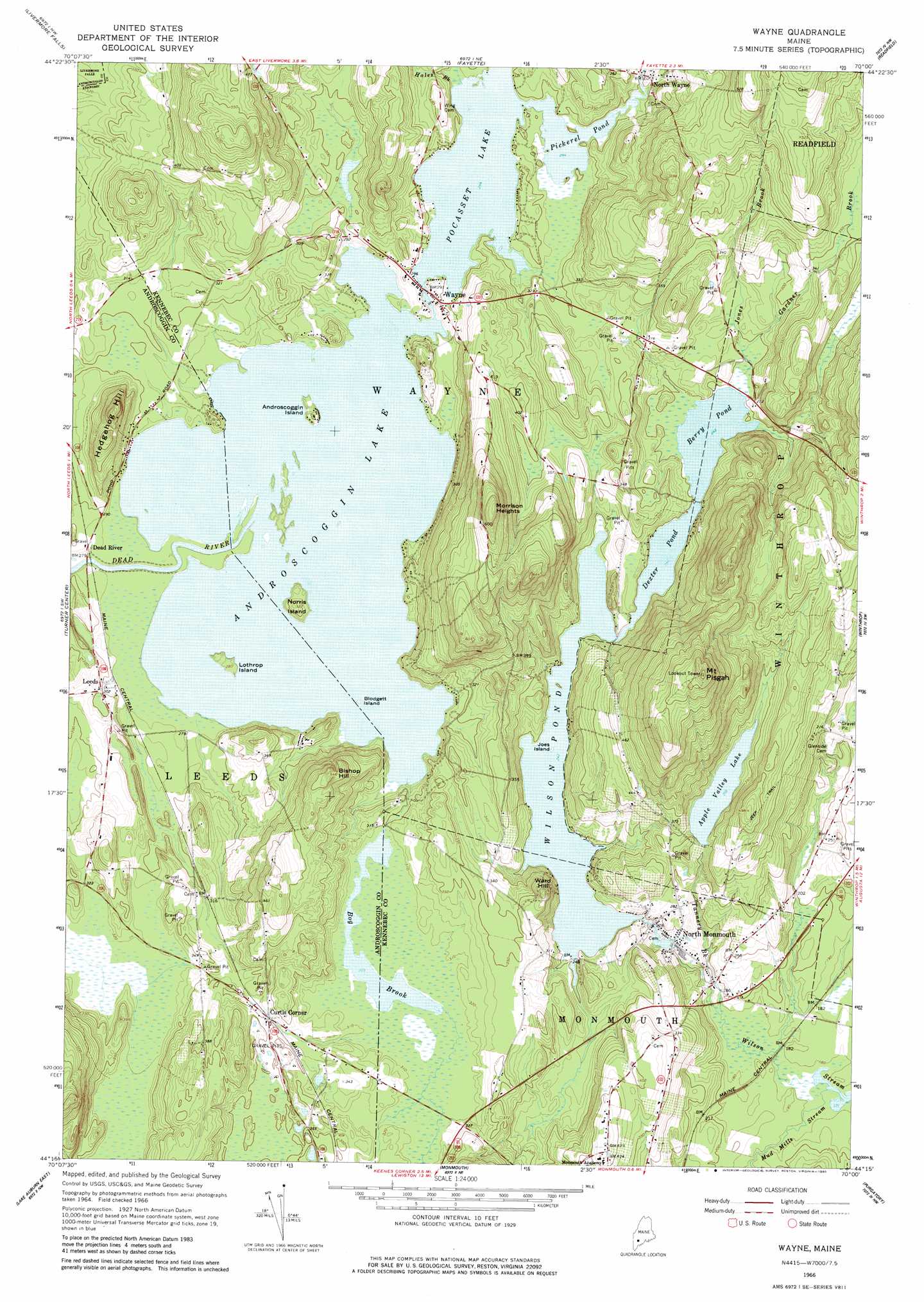
Wayne Topo Map Maine
To zoom in, hover over the map of Wayne
USGS Topo Quad 44070c1 - 1:24,000 scale
| Topo Map Name: | Wayne |
| USGS Topo Quad ID: | 44070c1 |
| Print Size: | ca. 21 1/4" wide x 27" high |
| Southeast Coordinates: | 44.25° N latitude / 70° W longitude |
| Map Center Coordinates: | 44.3125° N latitude / 70.0625° W longitude |
| U.S. State: | ME |
| Filename: | o44070c1.jpg |
| Download Map JPG Image: | Wayne topo map 1:24,000 scale |
| Map Type: | Topographic |
| Topo Series: | 7.5´ |
| Map Scale: | 1:24,000 |
| Source of Map Images: | United States Geological Survey (USGS) |
| Alternate Map Versions: |
Wayne ME 1966, updated 1968 Download PDF Buy paper map Wayne ME 1966, updated 1980 Download PDF Buy paper map Wayne ME 1966, updated 1980 Download PDF Buy paper map Wayne ME 2011 Download PDF Buy paper map Wayne ME 2014 Download PDF Buy paper map |
1:24,000 Topo Quads surrounding Wayne
East Dixfield |
Wilton |
Farmington Falls |
Belgrade Lakes |
Rome |
Canton |
Livermore Falls |
Fayette |
Readfield |
Belgrade |
Buckfield |
Turner Center |
Wayne |
Winthrop |
Augusta |
Lake Auburn West |
Lake Auburn East |
Monmouth |
Purgatory |
Gardiner |
Minot |
Lewiston |
Lisbon Falls North |
Bowdoinham |
Richmond |
> Back to 44070a1 at 1:100,000 scale
> Back to 44070a1 at 1:250,000 scale
> Back to U.S. Topo Maps home
Wayne topo map: Gazetteer
Wayne: Dams
Apple Valley Lake Dam elevation 97m 318′Lovejoy Pond Dam elevation 91m 298′
Lower Wilson Stream Dam elevation 64m 209′
Wayne Village Dam elevation 87m 285′
Wilson Pond Dam elevation 74m 242′
Wayne: Islands
Androscoggin Island elevation 86m 282′Blodgett Island elevation 82m 269′
Joes Island elevation 74m 242′
Lothrop Island elevation 85m 278′
Norris Island elevation 95m 311′
Wayne: Lakes
Androscoggin Lake elevation 82m 269′Berry Pond elevation 74m 242′
Dexter Pond elevation 74m 242′
Pickerel Pond elevation 86m 282′
Wayne: Populated Places
Curtis Corner elevation 108m 354′Leeds elevation 92m 301′
North Monmouth elevation 73m 239′
North Wayne elevation 96m 314′
Wayne elevation 92m 301′
Wayne: Reservoirs
Apple Valley Lake elevation 97m 318′Lovejoy Pond elevation 91m 298′
Pocasset Lake elevation 87m 285′
Wilson Pond elevation 74m 242′
Wilson Stream Reservoir elevation 64m 209′
Wayne: Streams
Bog Brook elevation 82m 269′Gardner Brook elevation 75m 246′
Hales Brook elevation 87m 285′
Jones Brook elevation 74m 242′
Mud Mills Stream elevation 53m 173′
Tannery Brook elevation 54m 177′
Wayne: Summits
Bishop Hill elevation 156m 511′Hedgehog Hill elevation 149m 488′
Morrison Heights elevation 204m 669′
Mount Pisgah elevation 246m 807′
Ward Hill elevation 129m 423′
Wayne digital topo map on disk
Buy this Wayne topo map showing relief, roads, GPS coordinates and other geographical features, as a high-resolution digital map file on DVD:
Maine, New Hampshire, Rhode Island & Eastern Massachusetts
Buy digital topo maps: Maine, New Hampshire, Rhode Island & Eastern Massachusetts