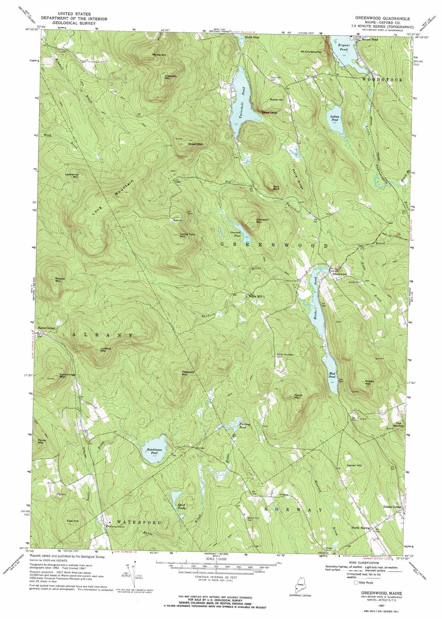
Greenwood Topo Map Maine
To zoom in, hover over the map of Greenwood
USGS Topo Quad 44070c6 - 1:24,000 scale
| Topo Map Name: | Greenwood |
| USGS Topo Quad ID: | 44070c6 |
| Print Size: | ca. 21 1/4" wide x 27" high |
| Southeast Coordinates: | 44.25° N latitude / 70.625° W longitude |
| Map Center Coordinates: | 44.3125° N latitude / 70.6875° W longitude |
| U.S. State: | ME |
| Filename: | o44070c6.jpg |
| Download Map JPG Image: | Greenwood topo map 1:24,000 scale |
| Map Type: | Topographic |
| Topo Series: | 7.5´ |
| Map Scale: | 1:24,000 |
| Source of Map Images: | United States Geological Survey (USGS) |
| Alternate Map Versions: |
Greenwood ME 1967, updated 1969 Download PDF Buy paper map Greenwood ME 1967, updated 1969 Download PDF Buy paper map Greenwood ME 2011 Download PDF Buy paper map Greenwood ME 2014 Download PDF Buy paper map |
1:24,000 Topo Quads surrounding Greenwood
Old Speck Mountain |
Puzzle Mountain |
East Andover |
Rumford |
Dixfield |
Gilead |
Bethel |
Bryant Pond |
Mount Zircon |
Worthley Pond |
Speckled Mountain |
East Stoneham |
Greenwood |
West Paris |
West Sumner |
Center Lovell |
North Waterford |
Ralph |
Norway |
Oxford |
Fryeburg |
Pleasant Mountain |
Bridgton |
Casco |
Mechanic Falls |
> Back to 44070a1 at 1:100,000 scale
> Back to 44070a1 at 1:250,000 scale
> Back to U.S. Topo Maps home
Greenwood topo map: Gazetteer
Greenwood: Cliffs
Payne Ledge elevation 267m 875′Greenwood: Dams
Bryant Pond Dam elevation 212m 695′Hicks Pond Dam elevation 207m 679′
Twitchell Pond Dam elevation 232m 761′
Greenwood: Lakes
Furlong Pond elevation 279m 915′Hutchinson Pond elevation 279m 915′
Indian Pond elevation 184m 603′
Mud Pond elevation 209m 685′
Oversett Pond elevation 281m 921′
Speck Ponds elevation 259m 849′
Greenwood: Populated Places
Greenwood elevation 208m 682′Hunts Corner elevation 315m 1033′
North Norway elevation 226m 741′
Willis Mill elevation 263m 862′
Greenwood: Reservoirs
Bryant Pond elevation 212m 695′Hicks Pond elevation 207m 679′
Twitchell Pond elevation 232m 761′
Greenwood: Ridges
Halls Ridge elevation 281m 921′Greenwood: Streams
Black Brook elevation 176m 577′Niles Brook elevation 177m 580′
Sanborn River elevation 208m 682′
Greenwood: Summits
Bald Bluff elevation 320m 1049′Carter Hill elevation 289m 948′
Cummings Mountain elevation 465m 1525′
Elwell Mountain elevation 502m 1646′
Fisk Hill elevation 275m 902′
Flints Mountain elevation 398m 1305′
Lawrence Mountain elevation 442m 1450′
Long Mountain elevation 557m 1827′
Lovejoy Mountain elevation 543m 1781′
Mount Abram elevation 604m 1981′
Mount Christopher elevation 345m 1131′
Noyes Mountain elevation 458m 1502′
Oversett Mountain elevation 416m 1364′
Patch Mountain elevation 476m 1561′
Peabody Mountain elevation 477m 1564′
Round Mountain elevation 557m 1827′
Rowe Hill elevation 351m 1151′
The Nubble elevation 281m 921′
Tibbetts Mountain elevation 553m 1814′
Uncle Tom Mountain elevation 516m 1692′
Greenwood digital topo map on disk
Buy this Greenwood topo map showing relief, roads, GPS coordinates and other geographical features, as a high-resolution digital map file on DVD:
Maine, New Hampshire, Rhode Island & Eastern Massachusetts
Buy digital topo maps: Maine, New Hampshire, Rhode Island & Eastern Massachusetts