Worthley Pond Topo Map Maine
To zoom in, hover over the map of Worthley Pond
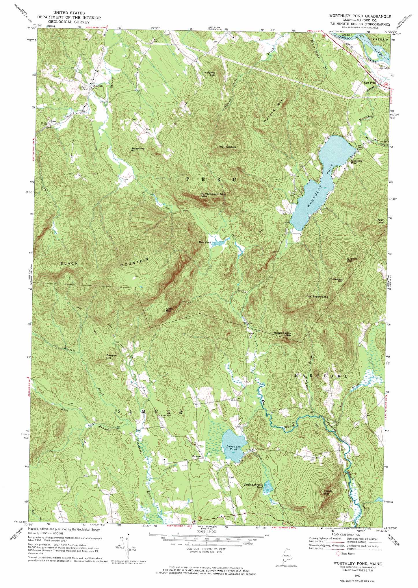
USGS Topo Quad 44070d4 - 1:24,000 scale
| Topo Map Name: | Worthley Pond |
| USGS Topo Quad ID: | 44070d4 |
| Print Size: | ca. 21 1/4" wide x 27" high |
| Southeast Coordinates: | 44.375° N latitude / 70.375° W longitude |
| Map Center Coordinates: | 44.4375° N latitude / 70.4375° W longitude |
| U.S. State: | ME |
| Filename: | o44070d4.jpg |
| Download Map JPG Image: | Worthley Pond topo map 1:24,000 scale |
| Map Type: | Topographic |
| Topo Series: | 7.5´ |
| Map Scale: | 1:24,000 |
| Source of Map Images: | United States Geological Survey (USGS) |
| Alternate Map Versions: |
Worthley Pond ME 1967, updated 1970 Download PDF Buy paper map Worthley Pond ME 2011 Download PDF Buy paper map Worthley Pond ME 2014 Download PDF Buy paper map |
1:24,000 Topo Quads surrounding Worthley Pond
Ellis Pond |
Roxbury |
Weld |
Mount Blue |
Farmington |
East Andover |
Rumford |
Dixfield |
East Dixfield |
Wilton |
Bryant Pond |
Mount Zircon |
Worthley Pond |
Canton |
Livermore Falls |
Greenwood |
West Paris |
West Sumner |
Buckfield |
Turner Center |
Ralph |
Norway |
Oxford |
Lake Auburn West |
Lake Auburn East |
> Back to 44070a1 at 1:100,000 scale
> Back to 44070a1 at 1:250,000 scale
> Back to U.S. Topo Maps home
Worthley Pond topo map: Gazetteer
Worthley Pond: Dams
Worthley Pond Dam elevation 174m 570′Worthley Pond: Lakes
Labrador Pond elevation 140m 459′Little Labrador Pond elevation 151m 495′
Mud Pond elevation 174m 570′
Worthley Pond: Populated Places
Dickvale elevation 155m 508′East Peru elevation 129m 423′
Sumner elevation 146m 479′
Worthley Pond elevation 178m 583′
Worthley Pond: Reservoirs
Worthley Pond elevation 174m 570′Worthley Pond: Streams
Bog Brook elevation 122m 400′Russell Brook elevation 148m 485′
Russell Brook elevation 128m 419′
Thomas Brook elevation 163m 534′
Worthley Pond: Summits
Allen Mountain elevation 488m 1601′Benson Hill elevation 331m 1085′
Black Mountain elevation 649m 2129′
Browns Mountain elevation 416m 1364′
Fields Hill elevation 338m 1108′
Hedgehog Hill elevation 212m 695′
Knights Hill elevation 331m 1085′
Poland Mountain elevation 396m 1299′
Ragged Jack Mountain elevation 343m 1125′
The Pinnacle elevation 521m 1709′
The Saddleback elevation 503m 1650′
Thompson Mountain elevation 441m 1446′
Tumbledown Dick Mountain elevation 463m 1519′
Worthley Pond digital topo map on disk
Buy this Worthley Pond topo map showing relief, roads, GPS coordinates and other geographical features, as a high-resolution digital map file on DVD:
Maine, New Hampshire, Rhode Island & Eastern Massachusetts
Buy digital topo maps: Maine, New Hampshire, Rhode Island & Eastern Massachusetts