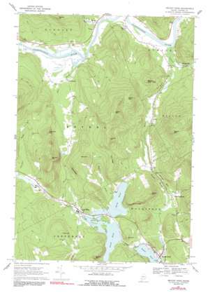
Bryant Pond Topo Map Maine
To zoom in, hover over the map of Bryant Pond
USGS Topo Quad 44070d6 - 1:24,000 scale
| Topo Map Name: | Bryant Pond |
| USGS Topo Quad ID: | 44070d6 |
| Print Size: | ca. 21 1/4" wide x 27" high |
| Southeast Coordinates: | 44.375° N latitude / 70.625° W longitude |
| Map Center Coordinates: | 44.4375° N latitude / 70.6875° W longitude |
| U.S. State: | ME |
| Filename: | o44070d6.jpg |
| Download Map JPG Image: | Bryant Pond topo map 1:24,000 scale |
| Map Type: | Topographic |
| Topo Series: | 7.5´ |
| Map Scale: | 1:24,000 |
| Source of Map Images: | United States Geological Survey (USGS) |
| Alternate Map Versions: |
Bryant Pond ME 1967, updated 1969 Download PDF Buy paper map Bryant Pond ME 1967, updated 1991 Download PDF Buy paper map Bryant Pond ME 1967, updated 1991 Download PDF Buy paper map Bryant Pond ME 2011 Download PDF Buy paper map Bryant Pond ME 2014 Download PDF Buy paper map |
1:24,000 Topo Quads surrounding Bryant Pond
> Back to 44070a1 at 1:100,000 scale
> Back to 44070a1 at 1:250,000 scale
> Back to U.S. Topo Maps home
Bryant Pond topo map: Gazetteer
Bryant Pond: Cliffs
Bucks Ledge elevation 354m 1161′Goss Ledge elevation 300m 984′
Bryant Pond: Dams
Outlet Dam elevation 219m 718′South Branch Dam elevation 220m 721′
Bryant Pond: Lakes
North Pond elevation 220m 721′South Pond elevation 220m 721′
Bryant Pond: Populated Places
Abbotts Mill elevation 196m 643′Bryant Pond elevation 214m 702′
East Bethel elevation 197m 646′
Hanover elevation 194m 636′
Locke Mills elevation 225m 738′
Milton elevation 199m 652′
North Woodstock elevation 221m 725′
Rumford Corner elevation 195m 639′
Bryant Pond: Reservoirs
Alder River South Branch Reservoir elevation 220m 721′Round Pond elevation 219m 718′
Bryant Pond: Ridges
Days Ridge elevation 433m 1420′Bryant Pond: Streams
Barkers Brook elevation 187m 613′Beaver Brook elevation 212m 695′
Billings Hill Brook elevation 201m 659′
Concord River elevation 185m 606′
McCrillian Brook elevation 220m 721′
Meadow Brook elevation 201m 659′
Otter Brook elevation 187m 613′
Pond Stream elevation 186m 610′
Bryant Pond: Summits
Barkers High Ledge elevation 357m 1171′Birds Hill elevation 441m 1446′
Bryant Mountain elevation 534m 1751′
Chandler Hill elevation 378m 1240′
Howard Mountain elevation 443m 1453′
Howe Hill elevation 348m 1141′
Kimball Hill elevation 550m 1804′
Moody Mountain elevation 434m 1423′
Oak Hill elevation 318m 1043′
Peaked Mountain elevation 380m 1246′
Pebley Mountain elevation 475m 1558′
Walkers Mountain elevation 465m 1525′
Wilbur Mountain elevation 574m 1883′
Bryant Pond digital topo map on disk
Buy this Bryant Pond topo map showing relief, roads, GPS coordinates and other geographical features, as a high-resolution digital map file on DVD:
Maine, New Hampshire, Rhode Island & Eastern Massachusetts
Buy digital topo maps: Maine, New Hampshire, Rhode Island & Eastern Massachusetts


