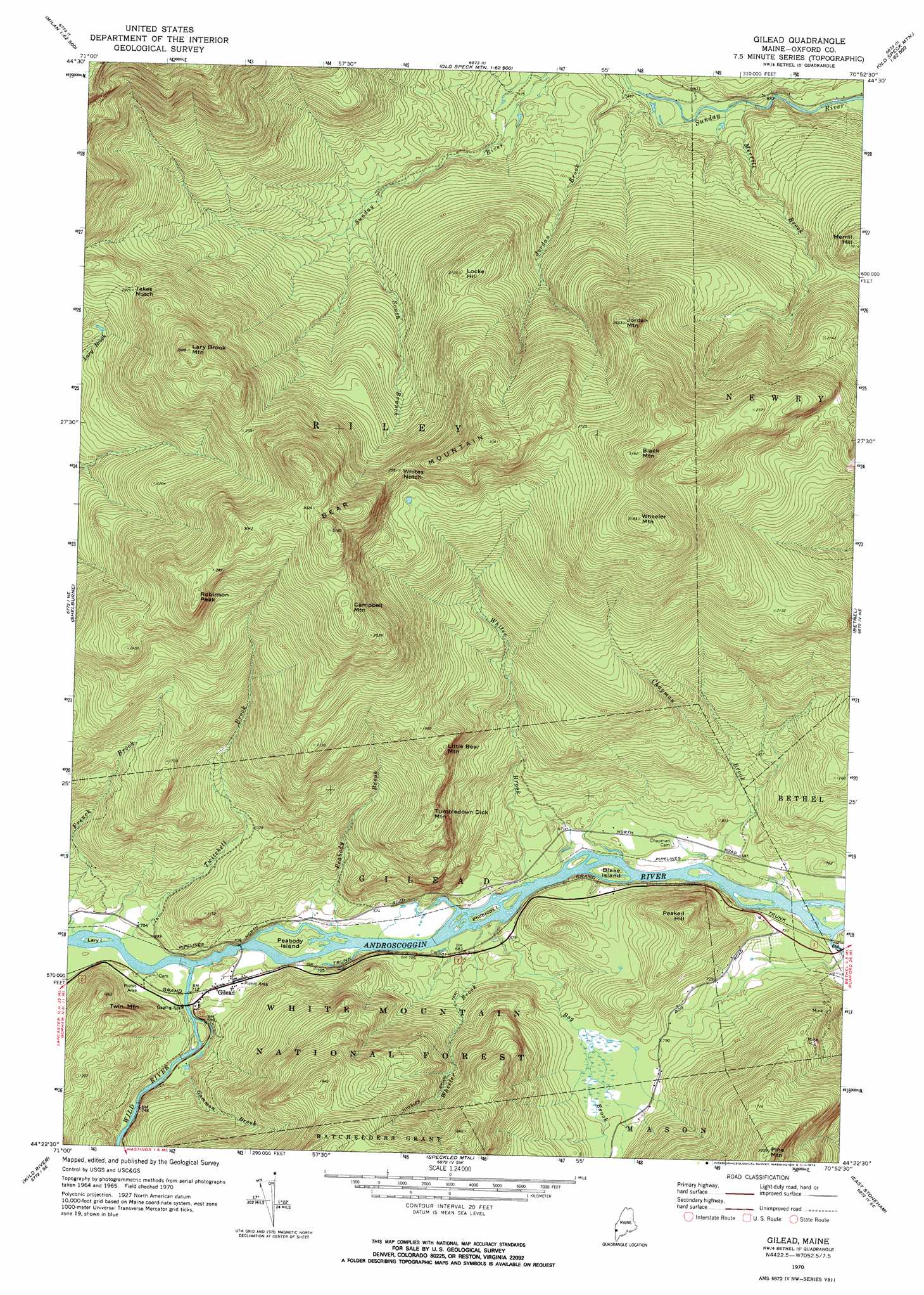
Gilead Topo Map Maine
To zoom in, hover over the map of Gilead
USGS Topo Quad 44070d8 - 1:24,000 scale
| Topo Map Name: | Gilead |
| USGS Topo Quad ID: | 44070d8 |
| Print Size: | ca. 21 1/4" wide x 27" high |
| Southeast Coordinates: | 44.375° N latitude / 70.875° W longitude |
| Map Center Coordinates: | 44.4375° N latitude / 70.9375° W longitude |
| U.S. State: | ME |
| Filename: | o44070d8.jpg |
| Download Map JPG Image: | Gilead topo map 1:24,000 scale |
| Map Type: | Topographic |
| Topo Series: | 7.5´ |
| Map Scale: | 1:24,000 |
| Source of Map Images: | United States Geological Survey (USGS) |
| Alternate Map Versions: |
Gilead ME 1970, updated 1972 Download PDF Buy paper map Gilead ME 1995, updated 2000 Download PDF Buy paper map Gilead ME 2012 Download PDF Buy paper map Gilead ME 2014 Download PDF Buy paper map |
| FStopo: | US Forest Service topo Gilead is available: Download FStopo PDF Download FStopo TIF |
1:24,000 Topo Quads surrounding Gilead
Teakettle Ridge |
Umbagog Lake South |
B Pond |
Andover |
Ellis Pond |
Milan |
Success Pond |
Old Speck Mountain |
Puzzle Mountain |
East Andover |
Berlin |
Shelburne |
Gilead |
Bethel |
Bryant Pond |
Carter Dome |
Wild River |
Speckled Mountain |
East Stoneham |
Greenwood |
Jackson |
Chatham |
Center Lovell |
North Waterford |
Ralph |
> Back to 44070a1 at 1:100,000 scale
> Back to 44070a1 at 1:250,000 scale
> Back to U.S. Topo Maps home
Gilead topo map: Gazetteer
Gilead: Gaps
Jakes Notch elevation 692m 2270′Whites Notch elevation 776m 2545′
Gilead: Islands
Blake Island elevation 201m 659′Lary Island elevation 210m 688′
Peabody Island elevation 207m 679′
Philbrook Island elevation 201m 659′
Gilead: Populated Places
Gilead elevation 216m 708′Gilead: Streams
Bog Brook elevation 201m 659′Bull Branch elevation 266m 872′
Chapman Brook elevation 201m 659′
Eames Brook elevation 237m 777′
French Brook elevation 208m 682′
Gammon Brook elevation 213m 698′
Jordan Brook elevation 267m 875′
Merrill Brook elevation 246m 807′
Peabody Brook elevation 202m 662′
Pleasant River elevation 196m 643′
South Branch Sunday River elevation 377m 1236′
Twitchell Brook elevation 208m 682′
Wheeler Brook elevation 201m 659′
Whites Brook elevation 199m 652′
Wild River elevation 202m 662′
Wild River elevation 202m 662′
Gilead: Summits
Bear Mountain elevation 955m 3133′Black Mountain elevation 963m 3159′
Campbell Mountain elevation 900m 2952′
Jordan Mountain elevation 805m 2641′
Lary Brook Mountain elevation 909m 2982′
Little Bear Mountain elevation 580m 1902′
Locke Hill elevation 639m 2096′
Peaked Hill elevation 417m 1368′
Pine Mountain elevation 611m 2004′
Robinson Peak elevation 891m 2923′
Tumbledown Dick Mountain elevation 544m 1784′
Twin Mountain elevation 374m 1227′
Wheeler Mountain elevation 969m 3179′
Gilead digital topo map on disk
Buy this Gilead topo map showing relief, roads, GPS coordinates and other geographical features, as a high-resolution digital map file on DVD:
Maine, New Hampshire, Rhode Island & Eastern Massachusetts
Buy digital topo maps: Maine, New Hampshire, Rhode Island & Eastern Massachusetts