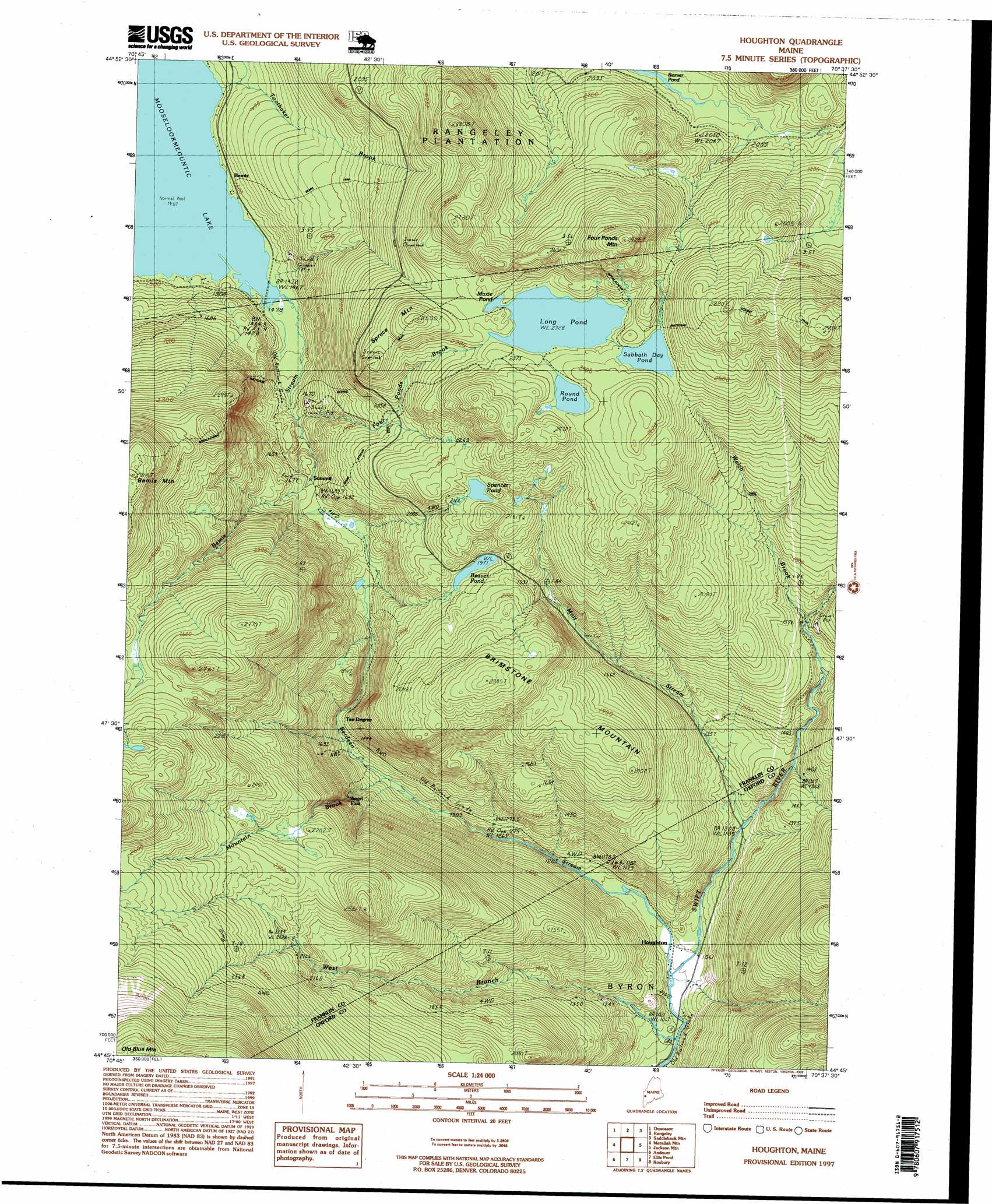
Houghton Topo Map Maine
To zoom in, hover over the map of Houghton
USGS Topo Quad 44070g6 - 1:24,000 scale
| Topo Map Name: | Houghton |
| USGS Topo Quad ID: | 44070g6 |
| Print Size: | ca. 21 1/4" wide x 27" high |
| Southeast Coordinates: | 44.75° N latitude / 70.625° W longitude |
| Map Center Coordinates: | 44.8125° N latitude / 70.6875° W longitude |
| U.S. State: | ME |
| Filename: | o44070g6.jpg |
| Download Map JPG Image: | Houghton topo map 1:24,000 scale |
| Map Type: | Topographic |
| Topo Series: | 7.5´ |
| Map Scale: | 1:24,000 |
| Source of Map Images: | United States Geological Survey (USGS) |
| Alternate Map Versions: |
Houghton ME 1978, updated 1983 Download PDF Buy paper map Houghton ME 1984, updated 1985 Download PDF Buy paper map Houghton ME 1997, updated 1999 Download PDF Buy paper map Houghton ME 2011 Download PDF Buy paper map Houghton ME 2014 Download PDF Buy paper map |
1:24,000 Topo Quads surrounding Houghton
Lincoln Pond |
Kennebago |
Kennebago Lake |
Quill Hill |
Black Nubble |
Richardson Pond |
Oquossoc |
Rangeley |
Saddleback Mountain |
Redington |
Middle Dam |
Metallak Mountain |
Houghton |
Jackson Mountain |
Madrid |
B Pond |
Andover |
Ellis Pond |
Roxbury |
Weld |
Old Speck Mountain |
Puzzle Mountain |
East Andover |
Rumford |
Dixfield |
> Back to 44070e1 at 1:100,000 scale
> Back to 44070a1 at 1:250,000 scale
> Back to U.S. Topo Maps home
Houghton topo map: Gazetteer
Houghton: Falls
Angel Falls elevation 474m 1555′Houghton: Lakes
Beaver Pond elevation 620m 2034′Beaver Pond elevation 602m 1975′
Long Pond elevation 709m 2326′
Maxie Pond elevation 709m 2326′
Round Pond elevation 722m 2368′
Sabbath Day Pond elevation 722m 2368′
Spencer Pond elevation 664m 2178′
Houghton: Populated Places
Bemis elevation 457m 1499′Houghton elevation 324m 1062′
Ten Degree elevation 460m 1509′
Houghton: Streams
Bemis Stream elevation 446m 1463′Berdeen Stream elevation 315m 1033′
Four Ponds Brook elevation 491m 1610′
Mott Stream elevation 362m 1187′
Mountain Brook elevation 390m 1279′
Toothaker Brook elevation 452m 1482′
Welch Brook elevation 483m 1584′
West Branch Swift River elevation 315m 1033′
Houghton: Summits
Brimstone Mountain elevation 702m 2303′Four Ponds Mountain elevation 872m 2860′
Spruce Mountain elevation 735m 2411′
Houghton: Trails
Angel Falls Trail elevation 400m 1312′Bemis Stream Trail elevation 519m 1702′
Bemis Trail elevation 539m 1768′
Houghton digital topo map on disk
Buy this Houghton topo map showing relief, roads, GPS coordinates and other geographical features, as a high-resolution digital map file on DVD:
Maine, New Hampshire, Rhode Island & Eastern Massachusetts
Buy digital topo maps: Maine, New Hampshire, Rhode Island & Eastern Massachusetts