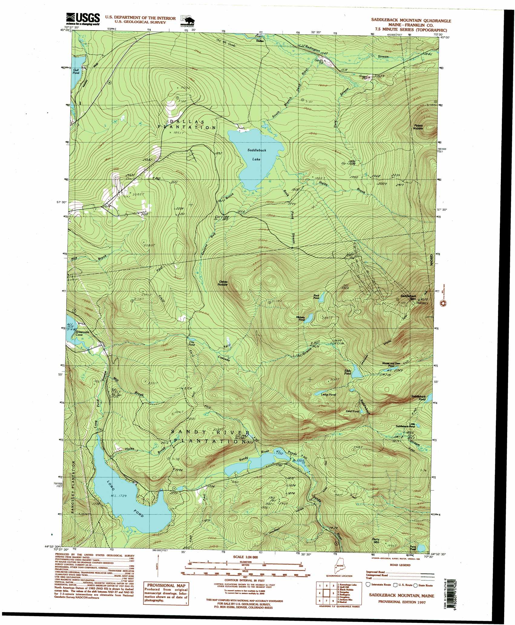
Saddleback Mountain Topo Map Maine
To zoom in, hover over the map of Saddleback Mountain
USGS Topo Quad 44070h5 - 1:24,000 scale
| Topo Map Name: | Saddleback Mountain |
| USGS Topo Quad ID: | 44070h5 |
| Print Size: | ca. 21 1/4" wide x 27" high |
| Southeast Coordinates: | 44.875° N latitude / 70.5° W longitude |
| Map Center Coordinates: | 44.9375° N latitude / 70.5625° W longitude |
| U.S. State: | ME |
| Filename: | o44070h5.jpg |
| Download Map JPG Image: | Saddleback Mountain topo map 1:24,000 scale |
| Map Type: | Topographic |
| Topo Series: | 7.5´ |
| Map Scale: | 1:24,000 |
| Source of Map Images: | United States Geological Survey (USGS) |
| Alternate Map Versions: |
Saddleback Mountain ME 1977, updated 1983 Download PDF Buy paper map Saddleback Mountain ME 1985, updated 1985 Download PDF Buy paper map Saddleback Mountain ME 1985, updated 1985 Download PDF Buy paper map Saddleback Mountain ME 1997, updated 1999 Download PDF Buy paper map Saddleback Mountain ME 2011 Download PDF Buy paper map Saddleback Mountain ME 2014 Download PDF Buy paper map |
1:24,000 Topo Quads surrounding Saddleback Mountain
Little Kennebago Lake |
Black Mountain |
Tim Mountain |
Stratton |
The Horns |
Kennebago |
Kennebago Lake |
Quill Hill |
Black Nubble |
Sugarloaf Mountain |
Oquossoc |
Rangeley |
Saddleback Mountain |
Redington |
Mount Abraham |
Metallak Mountain |
Houghton |
Jackson Mountain |
Madrid |
Phillips |
Andover |
Ellis Pond |
Roxbury |
Weld |
Mount Blue |
> Back to 44070e1 at 1:100,000 scale
> Back to 44070a1 at 1:250,000 scale
> Back to U.S. Topo Maps home
Saddleback Mountain topo map: Gazetteer
Saddleback Mountain: Dams
City Pond Dam elevation 579m 1899′Dead River Dam elevation 534m 1751′
Flagg Dam elevation 458m 1502′
Saddleback Mountain: Lakes
Eddy Pond elevation 805m 2641′Ethel Pond elevation 710m 2329′
Ledge Pond elevation 902m 2959′
Little Saddleback Pond elevation 598m 1961′
Long Pond elevation 527m 1729′
Midway Pond elevation 830m 2723′
Moose and Deer Pond elevation 838m 2749′
Perry Pond elevation 497m 1630′
Rock Pond elevation 834m 2736′
Sandy River Ponds elevation 519m 1702′
Saddleback Mountain: Pillars
Piazza Rock elevation 811m 2660′Saddleback Mountain: Populated Places
Dallas elevation 461m 1512′Saddleback Mountain: Reservoirs
City Pond elevation 579m 1899′Saddleback Lake elevation 534m 1751′
Saddleback Mountain: Streams
Cascade Stream elevation 468m 1535′Cold Stream elevation 467m 1532′
Geneva Bog Brook elevation 533m 1748′
Haley Brook elevation 535m 1755′
Haley Brook elevation 541m 1774′
Long Pond Stream elevation 463m 1519′
Mill Brook elevation 525m 1722′
Redington Stream elevation 464m 1522′
Rock Pond Stream elevation 534m 1751′
Saddleback Mountain: Summits
Oakes Nubble elevation 786m 2578′Perry Mountain elevation 549m 1801′
Potato Nubble elevation 893m 2929′
Saddleback Mountain elevation 1231m 4038′
Saddleback Mountain: Trails
Piazza Rock Trail elevation 748m 2454′Saddleback Mountain digital topo map on disk
Buy this Saddleback Mountain topo map showing relief, roads, GPS coordinates and other geographical features, as a high-resolution digital map file on DVD:
Maine, New Hampshire, Rhode Island & Eastern Massachusetts
Buy digital topo maps: Maine, New Hampshire, Rhode Island & Eastern Massachusetts