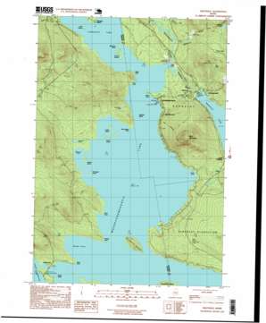
Oquossoc Topo Map Maine
To zoom in, hover over the map of Oquossoc
USGS Topo Quad 44070h7 - 1:24,000 scale
| Topo Map Name: | Oquossoc |
| USGS Topo Quad ID: | 44070h7 |
| Print Size: | ca. 21 1/4" wide x 27" high |
| Southeast Coordinates: | 44.875° N latitude / 70.75° W longitude |
| Map Center Coordinates: | 44.9375° N latitude / 70.8125° W longitude |
| U.S. State: | ME |
| Filename: | o44070h7.jpg |
| Download Map JPG Image: | Oquossoc topo map 1:24,000 scale |
| Map Type: | Topographic |
| Topo Series: | 7.5´ |
| Map Scale: | 1:24,000 |
| Source of Map Images: | United States Geological Survey (USGS) |
| Alternate Map Versions: |
Oquossoc ME 1977, updated 1983 Download PDF Buy paper map Oquossoc ME 1984, updated 1985 Download PDF Buy paper map Oquossoc ME 1984, updated 1985 Download PDF Buy paper map Oquossoc ME 1997, updated 1999 Download PDF Buy paper map Oquossoc ME 2011 Download PDF Buy paper map Oquossoc ME 2014 Download PDF Buy paper map |
1:24,000 Topo Quads surrounding Oquossoc
> Back to 44070e1 at 1:100,000 scale
> Back to 44070a1 at 1:250,000 scale
> Back to U.S. Topo Maps home
Oquossoc topo map: Gazetteer
Oquossoc: Bays
Echo Cove elevation 446m 1463′Sandy Cove elevation 446m 1463′
Wildwood Cove elevation 446m 1463′
Oquossoc: Capes
Birch Point elevation 446m 1463′Black Point elevation 446m 1463′
Brandy Point elevation 450m 1476′
Eagle Point elevation 446m 1463′
Spots Point elevation 448m 1469′
Stony Batter Point elevation 448m 1469′
Oquossoc: Dams
Rangeley Lake Dam elevation 458m 1502′Upper Dam elevation 445m 1459′
Oquossoc: Islands
Birch Island elevation 446m 1463′Blueberry Island elevation 446m 1463′
Browns Island elevation 447m 1466′
Dollar Island elevation 446m 1463′
Farrington Island elevation 446m 1463′
Griffin Island elevation 447m 1466′
Indian Rock elevation 446m 1463′
Johnson Island elevation 446m 1463′
Lunch Island elevation 446m 1463′
Shelter Island elevation 446m 1463′
Students Island elevation 460m 1509′
Turner Island elevation 446m 1463′
Oquossoc: Lakes
Cupsuptic Lake elevation 446m 1463′Ellis Pond elevation 546m 1791′
Goodwin Pond elevation 448m 1469′
Little Mud Pond elevation 462m 1515′
Nutting Pond elevation 558m 1830′
Oquossoc: Parks
Stephen Phillips Preserve elevation 453m 1486′Oquossoc: Pillars
Bowley Rock elevation 478m 1568′Oquossoc: Populated Places
Bald Mountain elevation 454m 1489′Macy elevation 470m 1541′
Mooselookmeguntic elevation 451m 1479′
Mountainview elevation 470m 1541′
Oquossoc elevation 466m 1528′
Pleasant Island elevation 449m 1473′
South Rangeley elevation 472m 1548′
Upper Dam elevation 448m 1469′
Oquossoc: Post Offices
Oquossoc Post Office elevation 467m 1532′Oquossoc: Reservoirs
Mooselookmeguntic Lake elevation 446m 1463′Rangeley Lake elevation 458m 1502′
Oquossoc: Streams
Kennebago River elevation 451m 1479′Otter Brook elevation 446m 1463′
Rangeley River elevation 463m 1519′
Whetstone Brook elevation 451m 1479′
Oquossoc: Summits
Bald Mountain elevation 750m 2460′Oquossoc: Swamps
Hayno Bog elevation 511m 1676′Oquossoc: Trails
Milrose Trail elevation 469m 1538′Oquossoc digital topo map on disk
Buy this Oquossoc topo map showing relief, roads, GPS coordinates and other geographical features, as a high-resolution digital map file on DVD:
Maine, New Hampshire, Rhode Island & Eastern Massachusetts
Buy digital topo maps: Maine, New Hampshire, Rhode Island & Eastern Massachusetts


