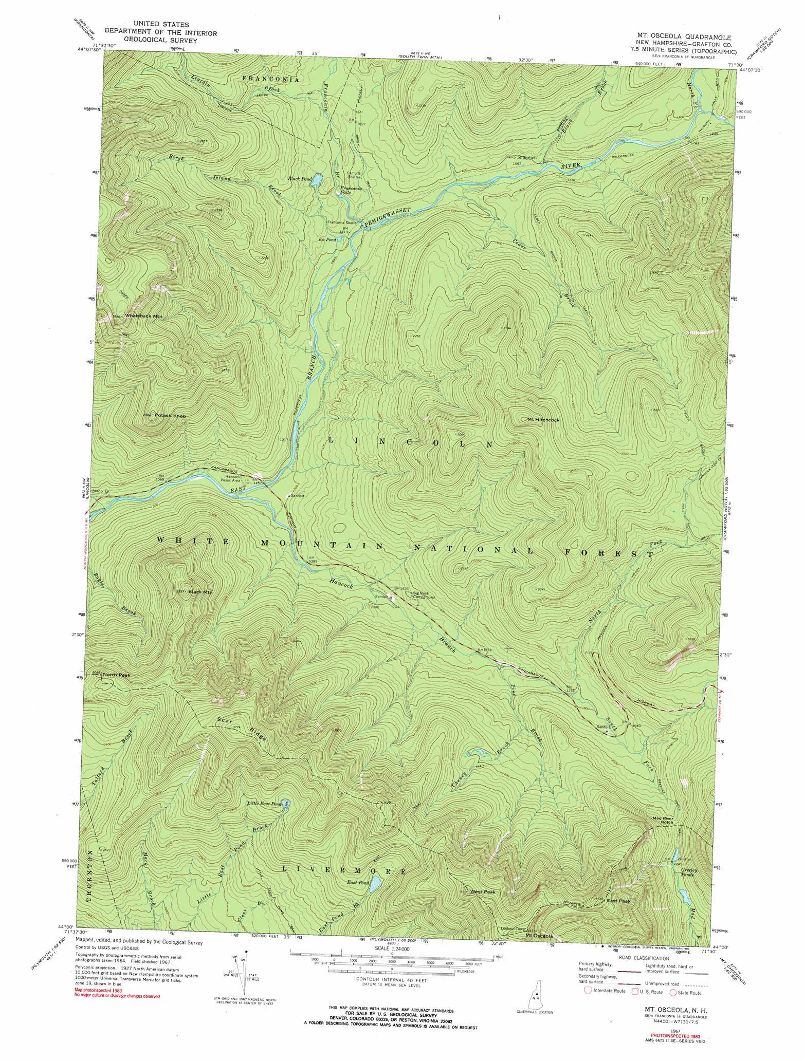
Mount Osceola Topo Map New Hampshire
To zoom in, hover over the map of Mount Osceola
USGS Topo Quad 44071a5 - 1:24,000 scale
| Topo Map Name: | Mount Osceola |
| USGS Topo Quad ID: | 44071a5 |
| Print Size: | ca. 21 1/4" wide x 27" high |
| Southeast Coordinates: | 44° N latitude / 71.5° W longitude |
| Map Center Coordinates: | 44.0625° N latitude / 71.5625° W longitude |
| U.S. State: | NH |
| Filename: | o44071a5.jpg |
| Download Map JPG Image: | Mount Osceola topo map 1:24,000 scale |
| Map Type: | Topographic |
| Topo Series: | 7.5´ |
| Map Scale: | 1:24,000 |
| Source of Map Images: | United States Geological Survey (USGS) |
| Alternate Map Versions: |
Mt. Osceola NH 1967, updated 1972 Download PDF Buy paper map Mt. Osceola NH 1967, updated 1972 Download PDF Buy paper map Mount Osceola NH 1967, updated 1990 Download PDF Buy paper map Mount Osceola NH 1995, updated 2000 Download PDF Buy paper map Mount Osceola NH 2012 Download PDF Buy paper map Mount Osceola NH 2015 Download PDF Buy paper map |
| FStopo: | US Forest Service topo Mount Osceola is available: Download FStopo PDF Download FStopo TIF |
1:24,000 Topo Quads surrounding Mount Osceola
Littleton |
Twin Mountain |
Mount Washington |
||
Sugar Hill |
Franconia |
South Twin Mountain |
Crawford Notch |
Stairs Mountain |
Mount Moosilauke |
Lincoln |
Mount Osceola |
Mount Carrigan |
Bartlett |
Mount Kineo |
Woodstock |
Waterville Valley |
Mount Tripyramid |
Mount Chocorua |
Rumney |
Plymouth |
Squam Mountains |
Center Sandwich |
Tamworth |
> Back to 44071a1 at 1:100,000 scale
> Back to 44070a1 at 1:250,000 scale
> Back to U.S. Topo Maps home
Mount Osceola topo map: Gazetteer
Mount Osceola: Falls
Franconia Falls elevation 474m 1555′Mount Osceola: Gaps
Mad River Notch elevation 698m 2290′Mount Osceola: Lakes
Black Pond elevation 489m 1604′East Pond elevation 789m 2588′
Greeley Ponds elevation 664m 2178′
Ice Pond elevation 434m 1423′
Little East Pond elevation 790m 2591′
Mount Osceola: Parks
Greeley Ponds Scenic Area elevation 716m 2349′Mount Osceola: Ridges
Scar Ridge elevation 1139m 3736′Mount Osceola: Streams
Birch Island Brook elevation 430m 1410′Black Brook elevation 483m 1584′
Cedar Brook elevation 454m 1489′
Cheney Brook elevation 571m 1873′
Clear Brook elevation 307m 1007′
Franconia Branch elevation 429m 1407′
Hancock Branch elevation 341m 1118′
Lincoln Brook elevation 503m 1650′
North Fork East Branch Pemigewasset River elevation 523m 1715′
North Fork Hancock Branch elevation 536m 1758′
Pine Brook elevation 489m 1604′
South Fork Hancock Branch elevation 534m 1751′
Mount Osceola: Summits
Black Mountain elevation 893m 2929′East Peak elevation 1260m 4133′
Mount Hitchcock elevation 1101m 3612′
Mount Osceola elevation 1315m 4314′
North Peak elevation 920m 3018′
Potash Knob elevation 813m 2667′
West Peak elevation 1248m 4094′
Whaleback Mountain elevation 1090m 3576′
Mount Osceola: Trails
Ceder Brook Trail elevation 584m 1916′East Pond Loop elevation 827m 2713′
East Pond Trail elevation 876m 2874′
Greeley Ponds Trail elevation 674m 2211′
Hancock Loop Trail elevation 868m 2847′
Little East Pond Trail elevation 618m 2027′
Mount Osceola Trail elevation 1210m 3969′
Osseo Trail elevation 955m 3133′
Wilderness Trail elevation 375m 1230′
Mount Osceola digital topo map on disk
Buy this Mount Osceola topo map showing relief, roads, GPS coordinates and other geographical features, as a high-resolution digital map file on DVD:
Maine, New Hampshire, Rhode Island & Eastern Massachusetts
Buy digital topo maps: Maine, New Hampshire, Rhode Island & Eastern Massachusetts