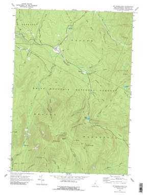
Mount Moosilauke Topo Map New Hampshire
To zoom in, hover over the map of Mount Moosilauke
USGS Topo Quad 44071a7 - 1:24,000 scale
| Topo Map Name: | Mount Moosilauke |
| USGS Topo Quad ID: | 44071a7 |
| Print Size: | ca. 21 1/4" wide x 27" high |
| Southeast Coordinates: | 44° N latitude / 71.75° W longitude |
| Map Center Coordinates: | 44.0625° N latitude / 71.8125° W longitude |
| U.S. State: | NH |
| Filename: | o44071a7.jpg |
| Download Map JPG Image: | Mount Moosilauke topo map 1:24,000 scale |
| Map Type: | Topographic |
| Topo Series: | 7.5´ |
| Map Scale: | 1:24,000 |
| Source of Map Images: | United States Geological Survey (USGS) |
| Alternate Map Versions: |
Mt Moosilauke NH 1967, updated 1973 Download PDF Buy paper map Mt. Moosilauke NH 1967, updated 1989 Download PDF Buy paper map Mt. Moosilauke NH 1967, updated 1989 Download PDF Buy paper map Mount Moosilauke NH 1995, updated 2000 Download PDF Buy paper map Mount Moosilauke NH 2012 Download PDF Buy paper map Mount Moosilauke NH 2015 Download PDF Buy paper map |
| FStopo: | US Forest Service topo Mount Moosilauke is available: Download FStopo PDF Download FStopo TIF |
1:24,000 Topo Quads surrounding Mount Moosilauke
> Back to 44071a1 at 1:100,000 scale
> Back to 44070a1 at 1:250,000 scale
> Back to U.S. Topo Maps home
Mount Moosilauke topo map: Gazetteer
Mount Moosilauke: Basins
Borrow Pit elevation 367m 1204′Jobildunk Ravine elevation 1093m 3585′
Mount Moosilauke: Dams
Beaver Pond Dam elevation 554m 1817′Mount Moosilauke: Gaps
Kinsman Notch elevation 568m 1863′Mount Moosilauke: Lakes
Gordon Pond elevation 782m 2565′Mud Pond elevation 689m 2260′
Mud Pond elevation 386m 1266′
Mount Moosilauke: Parks
Kinsman Notch Nature Area elevation 721m 2365′Mount Moosilauke: Populated Places
Lost River elevation 554m 1817′Wildwood elevation 385m 1263′
Mount Moosilauke: Reservoirs
Beaver Pond elevation 554m 1817′Mount Moosilauke: Ridges
Beech Hill elevation 712m 2335′Blue Ridge elevation 795m 2608′
Mount Moosilauke: Streams
Beaver Brook elevation 569m 1866′Black Brook elevation 374m 1227′
Bowen Brook elevation 329m 1079′
Clay Brook elevation 386m 1266′
Davis Brook elevation 320m 1049′
Dearth Brook elevation 310m 1017′
Little Tunnel Brook elevation 450m 1476′
Olesons Brook elevation 433m 1420′
Stark Falls Brook elevation 497m 1630′
Stony Brook elevation 419m 1374′
Tunnel Brook elevation 335m 1099′
Underhill Brook elevation 393m 1289′
Mount Moosilauke: Summits
Mount Blue elevation 1380m 4527′Mount Clough elevation 1083m 3553′
Mount Jim elevation 1270m 4166′
Mount Moosilauke elevation 1468m 4816′
Mount Waternomee elevation 1199m 3933′
Mount Wolf elevation 1051m 3448′
South Peak elevation 1381m 4530′
Mount Moosilauke: Trails
Asquamchumauke Ridge Trail elevation 965m 3166′Beaver Brook Trail elevation 1251m 4104′
Beech Hill Trail elevation 712m 2335′
Benton Trail elevation 1041m 3415′
Glencliff Trail elevation 1094m 3589′
Gorge Brook Trail elevation 923m 3028′
Moosilauke Carriage Road elevation 1221m 4005′
Reel Brook Trail elevation 583m 1912′
Ridge Trail elevation 1128m 3700′
Tunnel Brook Trail elevation 654m 2145′
Mount Moosilauke digital topo map on disk
Buy this Mount Moosilauke topo map showing relief, roads, GPS coordinates and other geographical features, as a high-resolution digital map file on DVD:
Maine, New Hampshire, Rhode Island & Eastern Massachusetts
Buy digital topo maps: Maine, New Hampshire, Rhode Island & Eastern Massachusetts


