South Twin Mountain Topo Map New Hampshire
To zoom in, hover over the map of South Twin Mountain
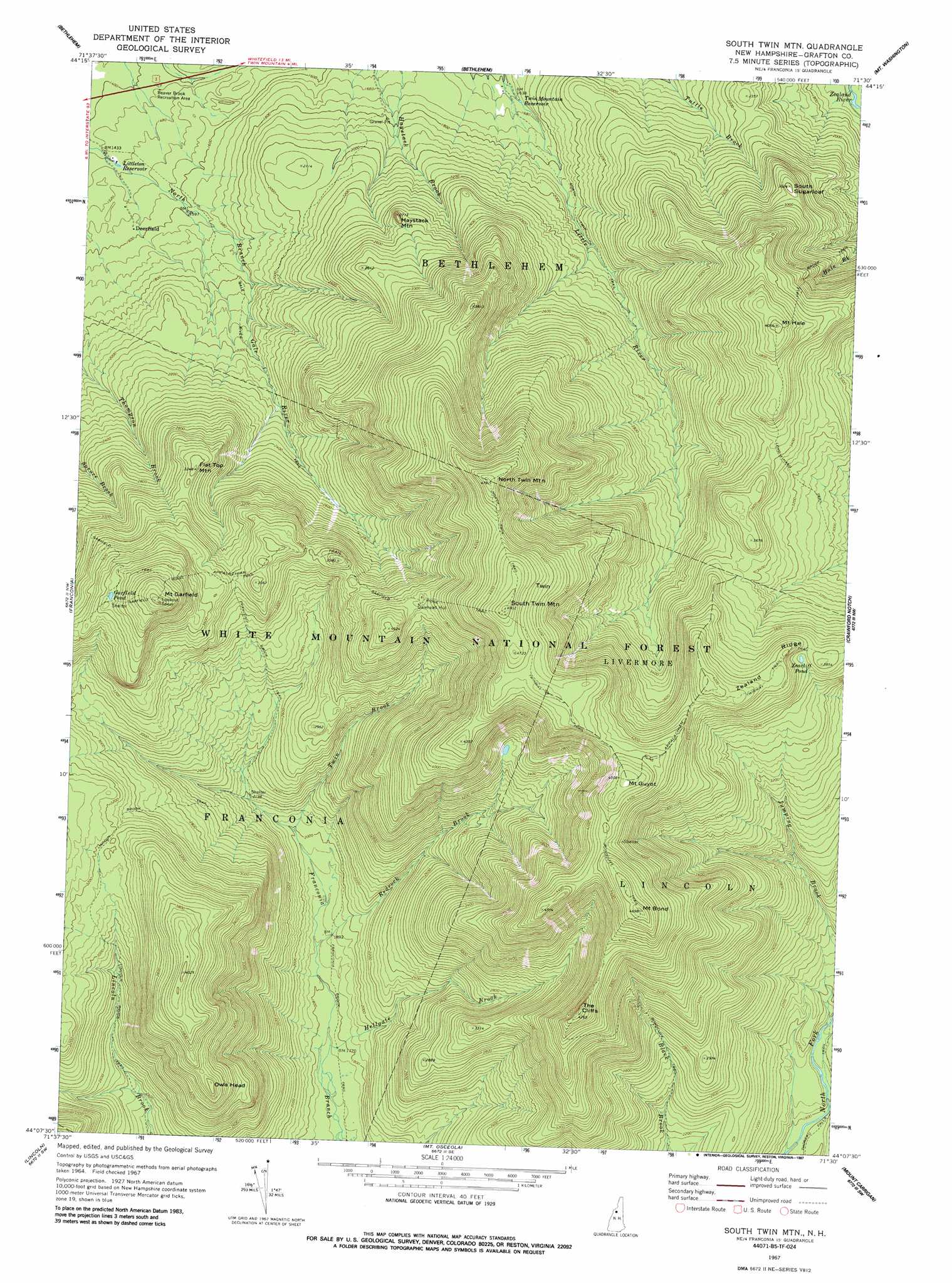
USGS Topo Quad 44071b5 - 1:24,000 scale
| Topo Map Name: | South Twin Mountain |
| USGS Topo Quad ID: | 44071b5 |
| Print Size: | ca. 21 1/4" wide x 27" high |
| Southeast Coordinates: | 44.125° N latitude / 71.5° W longitude |
| Map Center Coordinates: | 44.1875° N latitude / 71.5625° W longitude |
| U.S. State: | NH |
| Filename: | o44071b5.jpg |
| Download Map JPG Image: | South Twin Mountain topo map 1:24,000 scale |
| Map Type: | Topographic |
| Topo Series: | 7.5´ |
| Map Scale: | 1:24,000 |
| Source of Map Images: | United States Geological Survey (USGS) |
| Alternate Map Versions: |
South Twin Mtn NH 1967, updated 1972 Download PDF Buy paper map South Twin Mtn NH 1967, updated 1976 Download PDF Buy paper map South Twin Mtn NH 1967, updated 1988 Download PDF Buy paper map South Twin Mountain NH 1995, updated 2000 Download PDF Buy paper map South Twin Mountain NH 2012 Download PDF Buy paper map South Twin Mountain NH 2015 Download PDF Buy paper map |
| FStopo: | US Forest Service topo South Twin Mountain is available: Download FStopo PDF Download FStopo TIF |
1:24,000 Topo Quads surrounding South Twin Mountain
Miles Pond |
Lancaster |
Mount Crescent |
||
Littleton |
Twin Mountain |
Mount Washington |
||
Sugar Hill |
Franconia |
South Twin Mountain |
Crawford Notch |
Stairs Mountain |
Mount Moosilauke |
Lincoln |
Mount Osceola |
Mount Carrigan |
Bartlett |
Mount Kineo |
Woodstock |
Waterville Valley |
Mount Tripyramid |
Mount Chocorua |
> Back to 44071a1 at 1:100,000 scale
> Back to 44070a1 at 1:250,000 scale
> Back to U.S. Topo Maps home
South Twin Mountain topo map: Gazetteer
South Twin Mountain: Falls
Hawthorne Falls elevation 933m 3061′Hawthorne Falls elevation 924m 3031′
Thirteen Falls elevation 663m 2175′
South Twin Mountain: Lakes
Garfield Pond elevation 1179m 3868′Zeacliff Pond elevation 1131m 3710′
South Twin Mountain: Parks
Beaver Brook Recreation Area elevation 439m 1440′South Twin Mountain: Populated Places
Deerfield elevation 480m 1574′South Twin Mountain: Reservoirs
Littleton Reservoir elevation 447m 1466′Twin Mountain Reservoir elevation 504m 1653′
South Twin Mountain: Ridges
Zealand Ridge elevation 1235m 4051′South Twin Mountain: Streams
Hellgate Brook elevation 533m 1748′Redrock Brook elevation 558m 1830′
Twin Brook elevation 607m 1991′
South Twin Mountain: Summits
Flat Top Mountain elevation 987m 3238′Galehead Mountain elevation 1221m 4005′
Haystack Mountain elevation 820m 2690′
Mount Bond elevation 1428m 4685′
Mount Garfield elevation 1345m 4412′
Mount Guyot elevation 1396m 4580′
Mount Hale elevation 1234m 4048′
North Twin Mountain elevation 1452m 4763′
Owls Head elevation 1106m 3628′
South Sugarloaf elevation 915m 3001′
South Twin Mountain elevation 1491m 4891′
The Cliffs elevation 1294m 4245′
South Twin Mountain: Trails
Bondcliff Trail elevation 745m 2444′Franconia Brook Trail elevation 547m 1794′
Gale River Trail elevation 601m 1971′
Garfield Ridge Trail elevation 1159m 3802′
Hale Brook Trail elevation 847m 2778′
Lend-A-Hand Trail elevation 983m 3225′
Lincoln Brook Trail elevation 801m 2627′
North Twin Trail elevation 620m 2034′
North Twin Trail elevation 1361m 4465′
Twinway Trail elevation 1003m 3290′
South Twin Mountain digital topo map on disk
Buy this South Twin Mountain topo map showing relief, roads, GPS coordinates and other geographical features, as a high-resolution digital map file on DVD:
Maine, New Hampshire, Rhode Island & Eastern Massachusetts
Buy digital topo maps: Maine, New Hampshire, Rhode Island & Eastern Massachusetts