Twin Mountain Topo Map New Hampshire
To zoom in, hover over the map of Twin Mountain
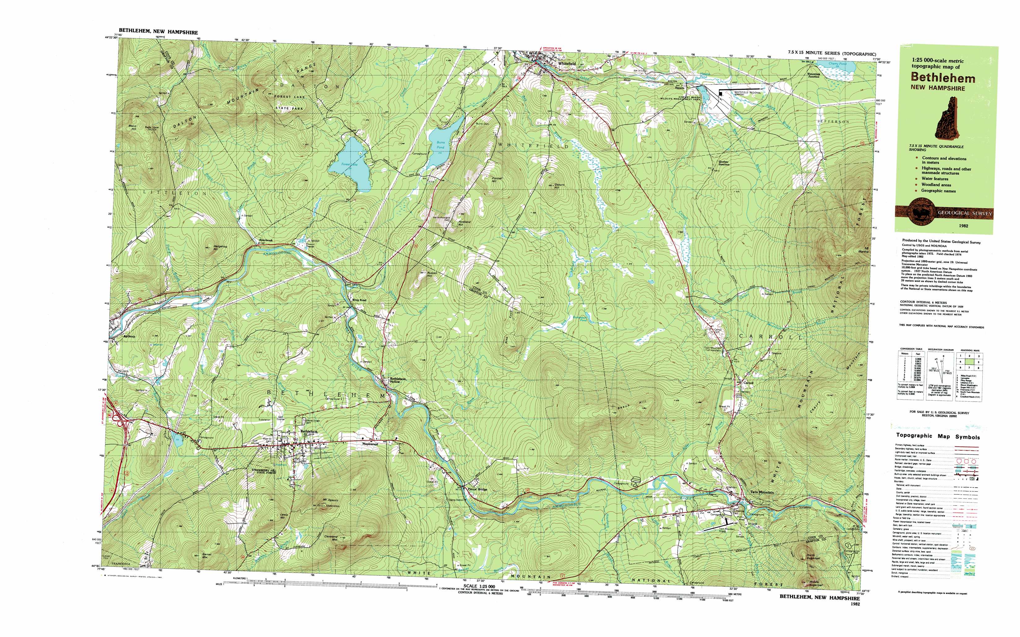
USGS Topo Quad 44071c5 - 1:25,000 scale
| Topo Map Name: | Twin Mountain |
| USGS Topo Quad ID: | 44071c5 |
| Print Size: | ca. 39" wide x 24" high |
| Southeast Coordinates: | 44.25° N latitude / 71.5° W longitude |
| Map Center Coordinates: | 44.3125° N latitude / 71.625° W longitude |
| U.S. State: | NH |
| Filename: | k44071c5.jpg |
| Download Map JPG Image: | Twin Mountain topo map 1:25,000 scale |
| Map Type: | Topographic |
| Topo Series: | 7.5´x15´ |
| Map Scale: | 1:25,000 |
| Source of Map Images: | United States Geological Survey (USGS) |
| Alternate Map Versions: |
Bethlehem NH 1982, updated 1983 Download PDF Buy paper map |
| FStopo: | US Forest Service topo Twin Mountain is available: Download FStopo PDF Download FStopo TIF |
1:24,000 Topo Quads surrounding Twin Mountain
Gallup Mills |
Stone Mountain |
Groveton |
Stark |
West Milan |
Miles Pond |
Lancaster |
Mount Crescent |
||
Littleton |
Twin Mountain |
Mount Washington |
||
Sugar Hill |
Franconia |
South Twin Mountain |
Crawford Notch |
Stairs Mountain |
Mount Moosilauke |
Lincoln |
Mount Osceola |
Mount Carrigan |
Bartlett |
> Back to 44071a1 at 1:100,000 scale
> Back to 44070a1 at 1:250,000 scale
> Back to U.S. Topo Maps home
Twin Mountain topo map: Gazetteer
Twin Mountain: Airports
Mount Washington Regional Airport elevation 320m 1049′Twin Mountain Airport elevation 440m 1443′
Whitefield Regional Airport elevation 319m 1046′
Twin Mountain: Crossings
Interchange 40 elevation 347m 1138′Twin Mountain: Dams
Airport Marsh Dam elevation 318m 1043′Apthorp Dam elevation 266m 872′
Bethlehem Dam elevation 342m 1122′
Burn Lake Dam elevation 310m 1017′
Forest Lake Dam elevation 337m 1105′
Miller Pond Dam elevation 333m 1092′
Twin Mountain: Lakes
Forest Lake elevation 337m 1105′Hazens Pond elevation 316m 1036′
Richardson Pond elevation 388m 1272′
Twin Mountain: Parks
Apthorp Common elevation 259m 849′Forest Lake State Park elevation 482m 1581′
Twin Mountain: Populated Places
Alderbrook elevation 296m 971′Apthorp elevation 272m 892′
Bethlehem elevation 438m 1437′
Carroll elevation 438m 1437′
Hazens elevation 313m 1026′
Maplewood elevation 445m 1459′
Newtons Mobile Park elevation 276m 905′
Pierce Bridge elevation 362m 1187′
Quebec Junction elevation 350m 1148′
Twin Mountain elevation 427m 1400′
Waumbeck Junction elevation 341m 1118′
Whitefield elevation 292m 958′
Twin Mountain: Reservoirs
Airport Marsh Reservoir elevation 318m 1043′Ammonoosuc River Reservoir elevation 342m 1122′
Ammonoosucuc River Reservoir elevation 266m 872′
Burns Pond elevation 310m 1017′
Miller Pond elevation 333m 1092′
Twin Mountain: Streams
Alder Brook elevation 406m 1332′Ayding Brook elevation 318m 1043′
Barrett Brook elevation 283m 928′
Bear Brook elevation 316m 1036′
Black Brook elevation 439m 1440′
Black Brook elevation 273m 895′
Black Brook elevation 349m 1145′
Bog Brook elevation 275m 902′
Carroll Stream elevation 314m 1030′
Carter Brook elevation 360m 1181′
Cherry Mountain Brook elevation 375m 1230′
Fowler Brook elevation 268m 879′
Hatch Brook elevation 294m 964′
Haystack Brook elevation 402m 1318′
Leonard Brook elevation 317m 1040′
Little River elevation 403m 1322′
Tuttle Brook elevation 421m 1381′
Zealand River elevation 438m 1437′
Twin Mountain: Summits
Beech Hill elevation 688m 2257′Cleveland Mountain elevation 715m 2345′
Garnet Mountain elevation 650m 2132′
Hedgehog Hill elevation 445m 1459′
Howland Hill elevation 516m 1692′
Kimbal Hill elevation 523m 1715′
Lewis Hill elevation 613m 2011′
Mann Hill elevation 635m 2083′
Middle Sugarloaf elevation 763m 2503′
Mount Agassiz elevation 719m 2358′
North Sugarloaf elevation 677m 2221′
Osburn Hill elevation 457m 1499′
Pine Knob elevation 477m 1564′
Russell Hill elevation 488m 1601′
Twin Mountain: Trails
Baby Twin Trail elevation 615m 2017′Black Brook Trail elevation 590m 1935′
Nubble Mountain Trail elevation 474m 1555′
Turtle Brook Trail elevation 487m 1597′
Twin Mountain digital topo map on disk
Buy this Twin Mountain topo map showing relief, roads, GPS coordinates and other geographical features, as a high-resolution digital map file on DVD:
Maine, New Hampshire, Rhode Island & Eastern Massachusetts
Buy digital topo maps: Maine, New Hampshire, Rhode Island & Eastern Massachusetts