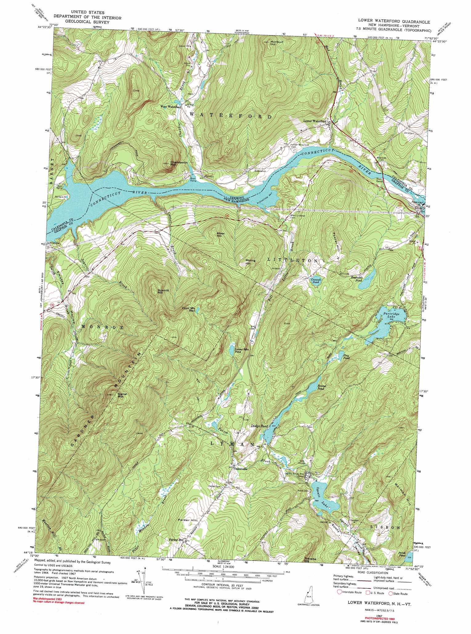
Lower Waterford Topo Map New Hampshire
To zoom in, hover over the map of Lower Waterford
USGS Topo Quad 44071c8 - 1:24,000 scale
| Topo Map Name: | Lower Waterford |
| USGS Topo Quad ID: | 44071c8 |
| Print Size: | ca. 21 1/4" wide x 27" high |
| Southeast Coordinates: | 44.25° N latitude / 71.875° W longitude |
| Map Center Coordinates: | 44.3125° N latitude / 71.9375° W longitude |
| U.S. States: | NH, VT |
| Filename: | o44071c8.jpg |
| Download Map JPG Image: | Lower Waterford topo map 1:24,000 scale |
| Map Type: | Topographic |
| Topo Series: | 7.5´ |
| Map Scale: | 1:24,000 |
| Source of Map Images: | United States Geological Survey (USGS) |
| Alternate Map Versions: |
Lower Waterford VT 1967, updated 1973 Download PDF Buy paper map Lower Waterford VT 1967, updated 1978 Download PDF Buy paper map Lower Waterford VT 1967, updated 1990 Download PDF Buy paper map Lower Waterford VT 2012 Download PDF Buy paper map Lower Waterford VT 2015 Download PDF Buy paper map |
1:24,000 Topo Quads surrounding Lower Waterford
Stannard |
Lyndonville |
Burke Mountain |
Gallup Mills |
Stone Mountain |
Saint Johnsbury |
Concord |
Miles Pond |
||
Barnet |
Lower Waterford |
Littleton |
||
Groton |
Woodsville |
Lisbon |
Sugar Hill |
Franconia |
East Corinth |
Newbury |
East Haverhill |
Mount Moosilauke |
Lincoln |
> Back to 44071a1 at 1:100,000 scale
> Back to 44070a1 at 1:250,000 scale
> Back to U.S. Topo Maps home
Lower Waterford topo map: Gazetteer
Lower Waterford: Dams
Dodge Pond Dam elevation 259m 849′Lower Waterford: Lakes
Caswell Pond elevation 352m 1154′Flag Pond elevation 255m 836′
Lower Mountain Pond elevation 385m 1263′
Ogontz Lake elevation 201m 659′
Partridge Lake elevation 258m 846′
Reynolds Pond elevation 320m 1049′
Round Pond elevation 253m 830′
Upper Mountain Pond elevation 519m 1702′
Lower Waterford: Populated Places
Lower Waterford elevation 246m 807′Parker Hill elevation 374m 1227′
Tinkerville elevation 289m 948′
West Waterford elevation 216m 708′
Lower Waterford: Post Offices
Lower Waterford Post Office elevation 243m 797′Lower Waterford: Reservoirs
Dodge Pond elevation 259m 849′Moore Reservoir elevation 245m 803′
Lower Waterford: Ridges
Foster Hill elevation 395m 1295′Gardner Mountain elevation 683m 2240′
Mormon Hill elevation 375m 1230′
Lower Waterford: Streams
Bill Little Brook elevation 197m 646′Carter Brook elevation 197m 646′
Chandler Brook elevation 197m 646′
Mad Brook elevation 200m 656′
Patten Brook elevation 201m 659′
Scarritt Brook elevation 197m 646′
Lower Waterford: Summits
Albee Hill elevation 390m 1279′Chamberlin Mountain elevation 365m 1197′
Hurtburt Hill elevation 542m 1778′
Mining Hill elevation 418m 1371′
Parker Hill elevation 391m 1282′
Scarritt Hill elevation 528m 1732′
Signal Mountain elevation 703m 2306′
Lower Waterford digital topo map on disk
Buy this Lower Waterford topo map showing relief, roads, GPS coordinates and other geographical features, as a high-resolution digital map file on DVD:
Maine, New Hampshire, Rhode Island & Eastern Massachusetts
Buy digital topo maps: Maine, New Hampshire, Rhode Island & Eastern Massachusetts