Berlin Topo Map New Hampshire
To zoom in, hover over the map of Berlin
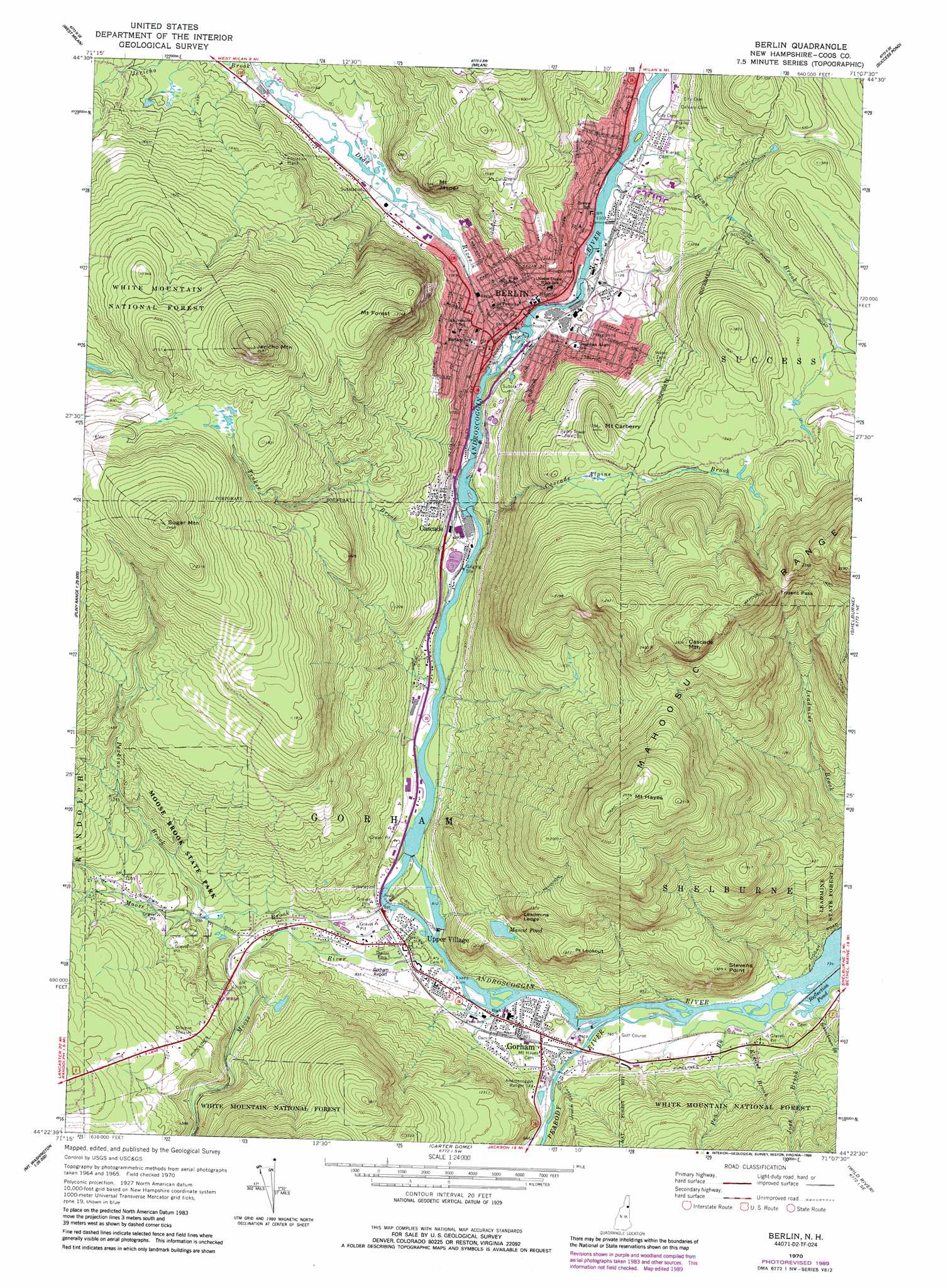
USGS Topo Quad 44071d2 - 1:24,000 scale
| Topo Map Name: | Berlin |
| USGS Topo Quad ID: | 44071d2 |
| Print Size: | ca. 21 1/4" wide x 27" high |
| Southeast Coordinates: | 44.375° N latitude / 71.125° W longitude |
| Map Center Coordinates: | 44.4375° N latitude / 71.1875° W longitude |
| U.S. State: | NH |
| Filename: | o44071d2.jpg |
| Download Map JPG Image: | Berlin topo map 1:24,000 scale |
| Map Type: | Topographic |
| Topo Series: | 7.5´ |
| Map Scale: | 1:24,000 |
| Source of Map Images: | United States Geological Survey (USGS) |
| Alternate Map Versions: |
Berlin NH 1970, updated 1972 Download PDF Buy paper map Berlin NH 1970, updated 1972 Download PDF Buy paper map Berlin NH 1970, updated 1987 Download PDF Buy paper map Berlin NH 1970, updated 1989 Download PDF Buy paper map Berlin NH 1995, updated 2001 Download PDF Buy paper map Berlin NH 2012 Download PDF Buy paper map Berlin NH 2015 Download PDF Buy paper map |
| FStopo: | US Forest Service topo Berlin is available: Download FStopo PDF Download FStopo TIF |
1:24,000 Topo Quads surrounding Berlin
Percy Peaks |
Dummer Ponds |
Teakettle Ridge |
Umbagog Lake South |
B Pond |
Stark |
West Milan |
Milan |
Success Pond |
Old Speck Mountain |
Mount Crescent |
Berlin |
Shelburne |
Gilead |
|
Mount Washington |
Carter Dome |
Wild River |
Speckled Mountain |
|
Crawford Notch |
Stairs Mountain |
Jackson |
Chatham |
Center Lovell |
> Back to 44071a1 at 1:100,000 scale
> Back to 44070a1 at 1:250,000 scale
> Back to U.S. Topo Maps home
Berlin topo map: Gazetteer
Berlin: Airports
Gorham Municipal Airport elevation 247m 810′Berlin: Bridges
Twelveth Street Bridge elevation 336m 1102′Berlin: Dams
Anderson Dam elevation 437m 1433′Cascade Alpine Water Supply Dam elevation 478m 1568′
Cascade Cross Power Station Dam elevation 330m 1082′
Cascade Dam elevation 272m 892′
Cascade Mill Aeration Lagoon Dam elevation 269m 882′
Gorham Dam elevation 232m 761′
Gorham Dam Brown Company elevation 245m 803′
J Brodie Smith Dam elevation 317m 1040′
Riverside Dam elevation 347m 1138′
Sawmill Dam elevation 330m 1082′
Berlin: Forests
Leadmine State Forest elevation 307m 1007′Berlin: Gaps
Trident Pass elevation 614m 2014′Berlin: Islands
Buck Island elevation 236m 774′Berlin: Lakes
Dead River Pond elevation 326m 1069′Mascot Pond elevation 321m 1053′
Reflection Pond elevation 223m 731′
Berlin: Parks
Gorham Common elevation 242m 793′Moose Brook State Park elevation 326m 1069′
Northern Forest Heritage Park elevation 335m 1099′
Berlin: Populated Places
Berlin elevation 311m 1020′Cascade elevation 319m 1046′
Gateway Trailer Park elevation 249m 816′
Gorham elevation 241m 790′
Upper Village elevation 246m 807′
Berlin: Post Offices
Berlin Post Office elevation 311m 1020′Gorham Post Office elevation 359m 1177′
Berlin: Reservoirs
Anderson Reservoir elevation 437m 1433′Androscoggin River Reservoir elevation 347m 1138′
Androscoggin River Reservoir elevation 245m 803′
Androscoggin River Reservoir elevation 272m 892′
Androscoggin River Reservoir elevation 330m 1082′
Androscoggin River Reservoir elevation 232m 761′
Berlin Reservoir elevation 391m 1282′
Cascade Brook Reservoir elevation 478m 1568′
Cascade Mill Lagoons elevation 269m 882′
J Brodie Smith Reservoir elevation 317m 1040′
Berlin: Streams
Bean Brook elevation 330m 1082′Cascade Alpine Brook elevation 268m 879′
Dead River elevation 304m 997′
Jericho Brook elevation 323m 1059′
Josh Brook elevation 224m 734′
Kidder Brook elevation 225m 738′
Moose Brook elevation 238m 780′
Moose River elevation 232m 761′
Pea Brook elevation 225m 738′
Peabody River elevation 226m 741′
Perkins Brook elevation 286m 938′
Schoolhouse Brook elevation 225m 738′
Tinker Brook elevation 269m 882′
Berlin: Summits
Cascade Mountain elevation 794m 2604′Jericho Mountain elevation 748m 2454′
Leadmine Ledge elevation 474m 1555′
Mount Carberry elevation 521m 1709′
Mount Forest elevation 619m 2030′
Mount Hayes elevation 776m 2545′
Mount Jasper elevation 449m 1473′
Point Lookout elevation 402m 1318′
Stevens Point elevation 417m 1368′
Sugar Mountain elevation 743m 2437′
Berlin: Trails
Sinclair Trail elevation 530m 1738′Berlin: Valleys
Mount Washington Valley elevation 243m 797′Berlin digital topo map on disk
Buy this Berlin topo map showing relief, roads, GPS coordinates and other geographical features, as a high-resolution digital map file on DVD:
Maine, New Hampshire, Rhode Island & Eastern Massachusetts
Buy digital topo maps: Maine, New Hampshire, Rhode Island & Eastern Massachusetts