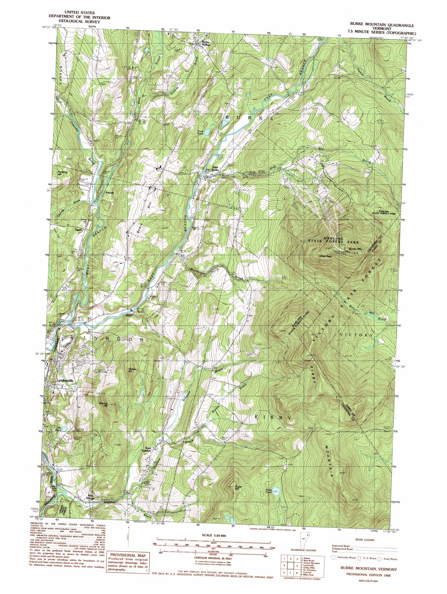
Burke Mountain Topo Map Vermont
To zoom in, hover over the map of Burke Mountain
USGS Topo Quad 44071e8 - 1:24,000 scale
| Topo Map Name: | Burke Mountain |
| USGS Topo Quad ID: | 44071e8 |
| Print Size: | ca. 21 1/4" wide x 27" high |
| Southeast Coordinates: | 44.5° N latitude / 71.875° W longitude |
| Map Center Coordinates: | 44.5625° N latitude / 71.9375° W longitude |
| U.S. State: | VT |
| Filename: | o44071e8.jpg |
| Download Map JPG Image: | Burke Mountain topo map 1:24,000 scale |
| Map Type: | Topographic |
| Topo Series: | 7.5´ |
| Map Scale: | 1:24,000 |
| Source of Map Images: | United States Geological Survey (USGS) |
| Alternate Map Versions: |
Burke Mountain VT 1988, updated 1988 Download PDF Buy paper map Burke Mountain VT 1988, updated 1988 Download PDF Buy paper map Burke Mountain VT 2012 Download PDF Buy paper map Burke Mountain VT 2015 Download PDF Buy paper map |
1:24,000 Topo Quads surrounding Burke Mountain
Orleans |
Westmore |
Island Pond |
Spectacle Pond |
Bloomfield |
Crystal Lake |
Sutton |
West Burke |
Seneca Mountain |
Maidstone Lake |
Stannard |
Lyndonville |
Burke Mountain |
Gallup Mills |
Stone Mountain |
Saint Johnsbury |
Concord |
Miles Pond |
||
Barnet |
Lower Waterford |
Littleton |
> Back to 44071e1 at 1:100,000 scale
> Back to 44070a1 at 1:250,000 scale
> Back to U.S. Topo Maps home
Burke Mountain topo map: Gazetteer
Burke Mountain: Airports
West Burke Aerodrome elevation 377m 1236′Burke Mountain: Bridges
Burrington Covered Bridge elevation 306m 1003′Burke Mountain: Dams
Great Falls Dam elevation 203m 666′Vail Dam elevation 217m 711′
Burke Mountain: Forests
Darling State Forest elevation 816m 2677′Burke Mountain: Lakes
Duck Pond elevation 309m 1013′Kirby Pond elevation 491m 1610′
Lily Pond elevation 244m 800′
Burke Mountain: Populated Places
Burke Hollow elevation 294m 964′East Burke elevation 264m 866′
East Lyndon elevation 288m 944′
Egypt elevation 243m 797′
Folsom elevation 222m 728′
North Kirby elevation 399m 1309′
Burke Mountain: Post Offices
East Burke Post Office elevation 255m 836′Burke Mountain: Streams
Barnes Brook elevation 341m 1118′Calendar Brook elevation 226m 741′
Dish Mill Brook elevation 251m 823′
East Branch Passumpsic River elevation 226m 741′
Hawkins Brook elevation 250m 820′
Mountain Brook elevation 233m 764′
Quimby Brook elevation 228m 748′
Roundy Brook elevation 241m 790′
Sheldon Brook elevation 201m 659′
Simpson Brook elevation 284m 931′
West Branch Passumpsic River elevation 217m 711′
Burke Mountain: Summits
Bemis Hill elevation 370m 1213′Burke Mountain elevation 976m 3202′
Graves Hill elevation 448m 1469′
Kirby Mountain elevation 833m 2732′
Pudding Hill elevation 381m 1250′
Shonya Hill elevation 464m 1522′
Sugar Hill elevation 622m 2040′
West Peak Burke Mountain elevation 956m 3136′
Burke Mountain: Trails
Bear Den Trail elevation 771m 2529′Burke Mountain digital topo map on disk
Buy this Burke Mountain topo map showing relief, roads, GPS coordinates and other geographical features, as a high-resolution digital map file on DVD:
Maine, New Hampshire, Rhode Island & Eastern Massachusetts
Buy digital topo maps: Maine, New Hampshire, Rhode Island & Eastern Massachusetts