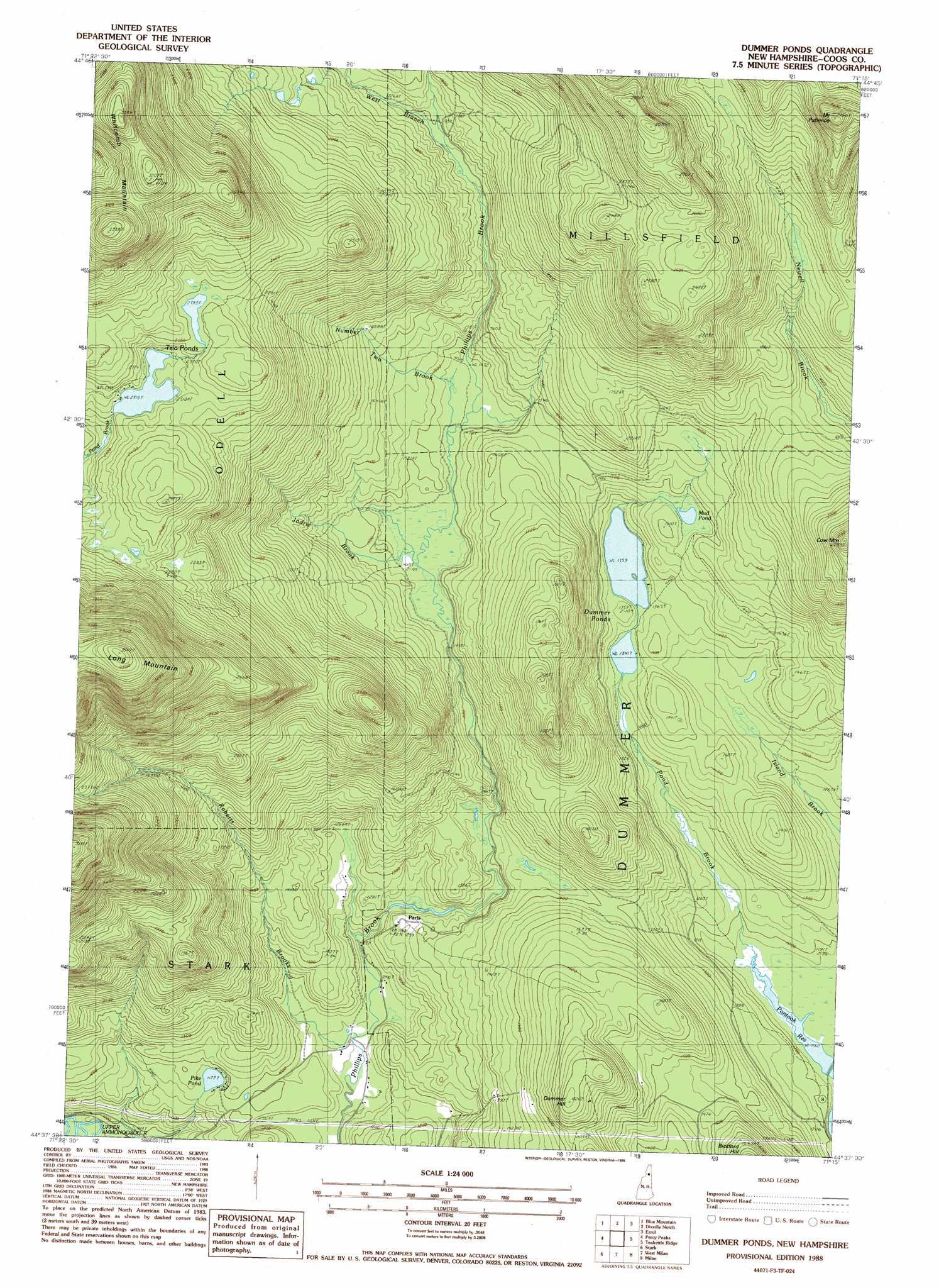
Dummer Ponds Topo Map New Hampshire
To zoom in, hover over the map of Dummer Ponds
USGS Topo Quad 44071f3 - 1:24,000 scale
| Topo Map Name: | Dummer Ponds |
| USGS Topo Quad ID: | 44071f3 |
| Print Size: | ca. 21 1/4" wide x 27" high |
| Southeast Coordinates: | 44.625° N latitude / 71.25° W longitude |
| Map Center Coordinates: | 44.6875° N latitude / 71.3125° W longitude |
| U.S. State: | NH |
| Filename: | o44071f3.jpg |
| Download Map JPG Image: | Dummer Ponds topo map 1:24,000 scale |
| Map Type: | Topographic |
| Topo Series: | 7.5´ |
| Map Scale: | 1:24,000 |
| Source of Map Images: | United States Geological Survey (USGS) |
| Alternate Map Versions: |
Dummer Ponds NH 1988, updated 1988 Download PDF Buy paper map Dummer Ponds NH 1988, updated 1988 Download PDF Buy paper map Dummer Ponds NH 1996, updated 2000 Download PDF Buy paper map Dummer Ponds NH 2012 Download PDF Buy paper map Dummer Ponds NH 2015 Download PDF Buy paper map |
| FStopo: | US Forest Service topo Dummer Ponds is available: Download FStopo PDF Download FStopo TIF |
1:24,000 Topo Quads surrounding Dummer Ponds
Monadnock Mountain |
Lovering Mountain |
Diamond Pond |
Mount Pisgah |
Wilsons Mills |
Tinkerville |
Blue Mountain |
Dixville Notch |
Errol |
Umbagog Lake North |
Stratford |
Percy Peaks |
Dummer Ponds |
Teakettle Ridge |
Umbagog Lake South |
Groveton |
Stark |
West Milan |
Milan |
Success Pond |
Lancaster |
Mount Crescent |
Berlin |
Shelburne |
> Back to 44071e1 at 1:100,000 scale
> Back to 44070a1 at 1:250,000 scale
> Back to U.S. Topo Maps home
Dummer Ponds topo map: Gazetteer
Dummer Ponds: Dams
Trio Pond Western Dam elevation 715m 2345′Dummer Ponds: Lakes
Dummer Ponds elevation 414m 1358′Mud Pond elevation 448m 1469′
Pike Pond elevation 359m 1177′
Trio Ponds elevation 706m 2316′
Dummer Ponds: Populated Places
Paris elevation 387m 1269′Dummer Ponds: Reservoirs
Trio Pond elevation 715m 2345′Dummer Ponds: Ridges
Whitcomb Mountain elevation 1011m 3316′Dummer Ponds: Streams
Jodrie Brook elevation 449m 1473′Number Two Brook elevation 451m 1479′
Pond Brook elevation 357m 1171′
Roberts Brooks elevation 344m 1128′
West Branch Phillips Brook elevation 511m 1676′
Dummer Ponds: Summits
Cow Mountain elevation 694m 2276′Dummer Hill elevation 555m 1820′
Mount Patience elevation 829m 2719′
Dummer Ponds digital topo map on disk
Buy this Dummer Ponds topo map showing relief, roads, GPS coordinates and other geographical features, as a high-resolution digital map file on DVD:
Maine, New Hampshire, Rhode Island & Eastern Massachusetts
Buy digital topo maps: Maine, New Hampshire, Rhode Island & Eastern Massachusetts