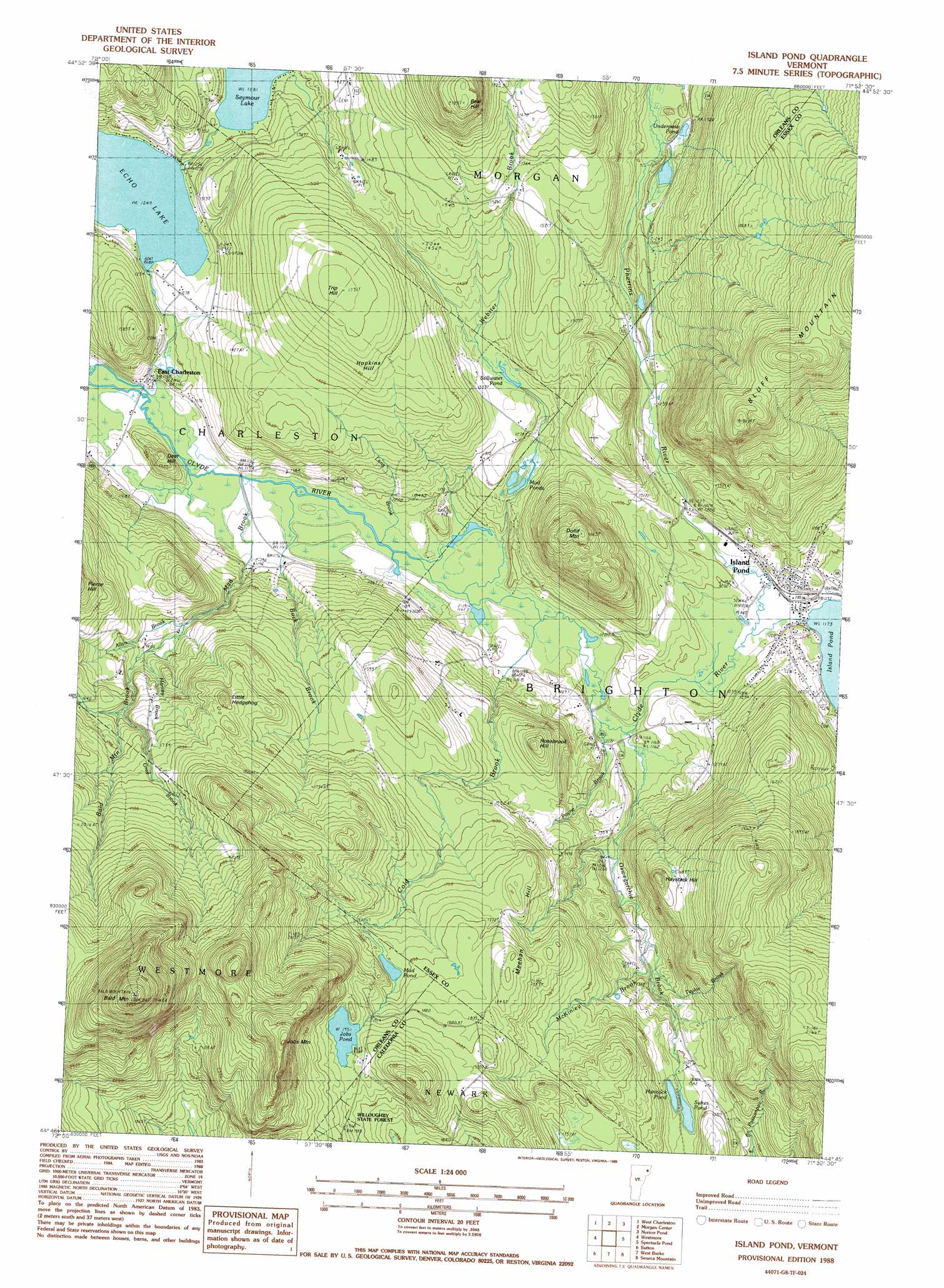
Island Pond Topo Map Vermont
To zoom in, hover over the map of Island Pond
USGS Topo Quad 44071g8 - 1:24,000 scale
| Topo Map Name: | Island Pond |
| USGS Topo Quad ID: | 44071g8 |
| Print Size: | ca. 21 1/4" wide x 27" high |
| Southeast Coordinates: | 44.75° N latitude / 71.875° W longitude |
| Map Center Coordinates: | 44.8125° N latitude / 71.9375° W longitude |
| U.S. State: | VT |
| Filename: | o44071g8.jpg |
| Download Map JPG Image: | Island Pond topo map 1:24,000 scale |
| Map Type: | Topographic |
| Topo Series: | 7.5´ |
| Map Scale: | 1:24,000 |
| Source of Map Images: | United States Geological Survey (USGS) |
| Alternate Map Versions: |
Island Pond VT 1988, updated 1988 Download PDF Buy paper map Island Pond VT 1988, updated 1988 Download PDF Buy paper map Island Pond VT 2012 Download PDF Buy paper map Island Pond VT 2015 Download PDF Buy paper map |
1:24,000 Topo Quads surrounding Island Pond
Newport |
West Charleston |
Morgan Center |
Norton Pond |
Averill Lake |
Orleans |
Westmore |
Island Pond |
Spectacle Pond |
Bloomfield |
Crystal Lake |
Sutton |
West Burke |
Seneca Mountain |
Maidstone Lake |
Stannard |
Lyndonville |
Burke Mountain |
Gallup Mills |
Stone Mountain |
> Back to 44071e1 at 1:100,000 scale
> Back to 44070a1 at 1:250,000 scale
> Back to U.S. Topo Maps home
Island Pond topo map: Gazetteer
Island Pond: Dams
Echo Lake Dam elevation 354m 1161′Seymour Lake Dam elevation 354m 1161′
Island Pond: Lakes
Echo Lake elevation 381m 1250′Hancock Pond elevation 463m 1519′
Jobs Pond elevation 595m 1952′
Mud Pond elevation 541m 1774′
Mud Ponds elevation 387m 1269′
Stillwater Pond elevation 430m 1410′
Sukes Pond elevation 463m 1519′
Underpass Pond elevation 399m 1309′
Island Pond: Parks
Island Pond Historic District elevation 375m 1230′Island Pond: Populated Places
East Charleston elevation 352m 1154′Island Pond elevation 365m 1197′
Island Pond: Post Offices
East Charleston Post Office elevation 351m 1151′Island Pond: Reservoirs
Echo Lake elevation 354m 1161′Seymour Lake elevation 354m 1161′
Island Pond: Streams
Allyn Brook elevation 412m 1351′Bald Mountain Brook elevation 498m 1633′
Buck Brook elevation 348m 1141′
Cold Brook elevation 350m 1148′
Gray Brook elevation 499m 1637′
Harvey Brook elevation 408m 1338′
Lang Brook elevation 347m 1138′
Mad Brook elevation 349m 1145′
McKinley Brook elevation 390m 1279′
Oswegatchie Brook elevation 353m 1158′
Payne Brook elevation 354m 1161′
Pherrins River elevation 354m 1161′
Taylor Brook elevation 400m 1312′
Webster Brook elevation 349m 1145′
Island Pond: Summits
Bald Mountain elevation 1010m 3313′Bear Hill elevation 647m 2122′
Deer Hill elevation 414m 1358′
Dolif Mountain elevation 572m 1876′
Haystack Hill elevation 555m 1820′
Hopkins Hill elevation 525m 1722′
Job Mountain elevation 845m 2772′
Little Hedgehog elevation 548m 1797′
Meehan Hill elevation 586m 1922′
Rosebrook Hill elevation 513m 1683′
Trip Hill elevation 538m 1765′
Island Pond digital topo map on disk
Buy this Island Pond topo map showing relief, roads, GPS coordinates and other geographical features, as a high-resolution digital map file on DVD:
Maine, New Hampshire, Rhode Island & Eastern Massachusetts
Buy digital topo maps: Maine, New Hampshire, Rhode Island & Eastern Massachusetts