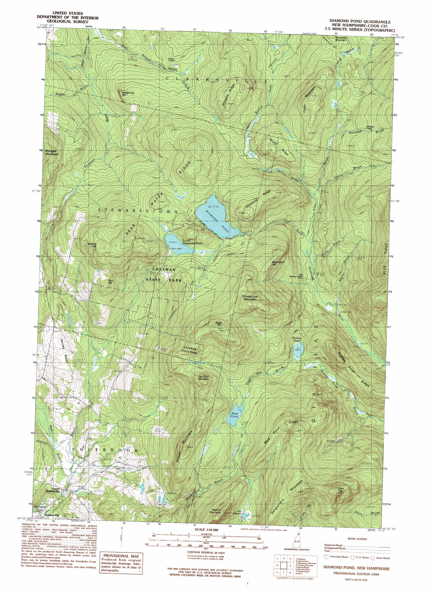
Diamond Pond Topo Map New Hampshire
To zoom in, hover over the map of Diamond Pond
USGS Topo Quad 44071h3 - 1:24,000 scale
| Topo Map Name: | Diamond Pond |
| USGS Topo Quad ID: | 44071h3 |
| Print Size: | ca. 21 1/4" wide x 27" high |
| Southeast Coordinates: | 44.875° N latitude / 71.25° W longitude |
| Map Center Coordinates: | 44.9375° N latitude / 71.3125° W longitude |
| U.S. State: | NH |
| Filename: | o44071h3.jpg |
| Download Map JPG Image: | Diamond Pond topo map 1:24,000 scale |
| Map Type: | Topographic |
| Topo Series: | 7.5´ |
| Map Scale: | 1:24,000 |
| Source of Map Images: | United States Geological Survey (USGS) |
| Alternate Map Versions: |
Diamond Pond NH 1989, updated 1989 Download PDF Buy paper map Diamond Pond NH 1989, updated 1989 Download PDF Buy paper map Diamond Pond NH 1996, updated 2000 Download PDF Buy paper map Diamond Pond NH 2012 Download PDF Buy paper map Diamond Pond NH 2015 Download PDF Buy paper map |
| FStopo: | US Forest Service topo Diamond Pond is available: Download FStopo PDF Download FStopo TIF |
1:24,000 Topo Quads surrounding Diamond Pond
Malvina |
Cowen Hill |
Second Connecticut Lake |
Rump Mountain |
|
Pittsburg |
Lake Francis |
Magalloway Mountain |
Bosebuck Mountain |
|
Monadnock Mountain |
Lovering Mountain |
Diamond Pond |
Mount Pisgah |
Wilsons Mills |
Tinkerville |
Blue Mountain |
Dixville Notch |
Errol |
Umbagog Lake North |
Stratford |
Percy Peaks |
Dummer Ponds |
Teakettle Ridge |
Umbagog Lake South |
> Back to 44071e1 at 1:100,000 scale
> Back to 44070a1 at 1:250,000 scale
> Back to U.S. Topo Maps home
Diamond Pond topo map: Gazetteer
Diamond Pond: Dams
Moose Brook Dam elevation 595m 1952′Mud Pond Dam elevation 692m 2270′
Diamond Pond: Lakes
Diamond Pond elevation 667m 2188′Lake Abeniki elevation 676m 2217′
Little Diamond Pond elevation 686m 2250′
Moose Pond (historical) elevation 631m 2070′
Nathan Pond elevation 613m 2011′
Diamond Pond: Parks
Coleman State Park elevation 722m 2368′Diamond Pond: Populated Places
Upper Kidderville elevation 445m 1459′Diamond Pond: Reservoirs
Moose Pond elevation 595m 1952′Mud Pond elevation 692m 2270′
Diamond Pond: Ridges
Dead Water Ridge elevation 715m 2345′Diamond Ridge elevation 741m 2431′
Mud Pond Ridge elevation 814m 2670′
Nathan Pond Ridge elevation 676m 2217′
South Ridge elevation 681m 2234′
Whipple Ridge elevation 703m 2306′
Diamond Pond: Streams
Bateman Brook elevation 644m 2112′East Branch Mohawk River elevation 402m 1318′
Ferguson Brook elevation 512m 1679′
Gulf Brook elevation 597m 1958′
Hix Brook elevation 503m 1650′
Horn Brook elevation 550m 1804′
Keyser Brook elevation 531m 1742′
Kidder Brook elevation 510m 1673′
Sugar Hill Brook elevation 611m 2004′
Tracy Brook elevation 563m 1847′
West Branch Mohawk River elevation 402m 1318′
Diamond Pond: Summits
Abeniki Mountain elevation 829m 2719′Black Bluff Hill elevation 765m 2509′
Cave Mountain elevation 964m 3162′
Cedar Mountain elevation 770m 2526′
Harvey Swell elevation 557m 1827′
Hedgehog Hill elevation 568m 1863′
Holden Hill elevation 779m 2555′
Keazer Mountain elevation 808m 2650′
Paul Hill elevation 664m 2178′
Sanguinary Mountain elevation 908m 2979′
Sugar Hill elevation 900m 2952′
Tumble Dick Mountain elevation 885m 2903′
Van Dyck Mountain elevation 817m 2680′
Diamond Pond digital topo map on disk
Buy this Diamond Pond topo map showing relief, roads, GPS coordinates and other geographical features, as a high-resolution digital map file on DVD:
Maine, New Hampshire, Rhode Island & Eastern Massachusetts
Buy digital topo maps: Maine, New Hampshire, Rhode Island & Eastern Massachusetts