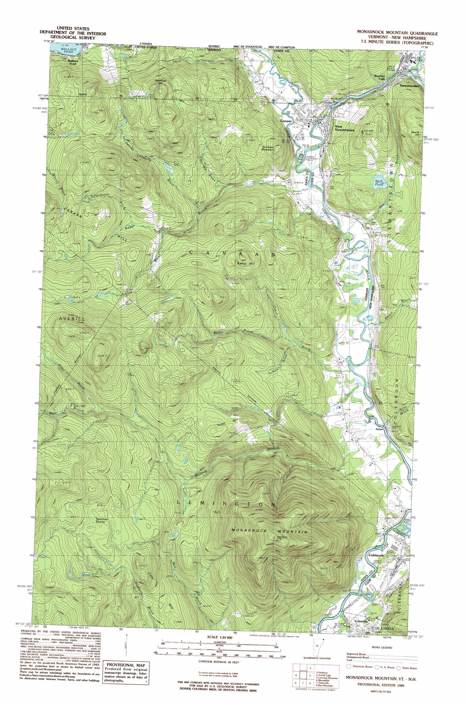
Monadnock Mountain Topo Map Vermont
To zoom in, hover over the map of Monadnock Mountain
USGS Topo Quad 44071h5 - 1:24,000 scale
| Topo Map Name: | Monadnock Mountain |
| USGS Topo Quad ID: | 44071h5 |
| Print Size: | ca. 21 1/4" wide x 27" high |
| Southeast Coordinates: | 44.875° N latitude / 71.5° W longitude |
| Map Center Coordinates: | 44.9375° N latitude / 71.5625° W longitude |
| U.S. States: | VT, NH |
| Filename: | o44071h5.jpg |
| Download Map JPG Image: | Monadnock Mountain topo map 1:24,000 scale |
| Map Type: | Topographic |
| Topo Series: | 7.5´ |
| Map Scale: | 1:24,000 |
| Source of Map Images: | United States Geological Survey (USGS) |
| Alternate Map Versions: |
Monadnock Mountain VT 1989, updated 1989 Download PDF Buy paper map Monadnock Mountain VT 2012 Download PDF Buy paper map Monadnock Mountain VT 2015 Download PDF Buy paper map |
1:24,000 Topo Quads surrounding Monadnock Mountain
Malvina |
Cowen Hill |
|||
Pittsburg |
Lake Francis |
|||
Norton Pond |
Averill Lake |
Monadnock Mountain |
Lovering Mountain |
Diamond Pond |
Spectacle Pond |
Bloomfield |
Tinkerville |
Blue Mountain |
Dixville Notch |
Seneca Mountain |
Maidstone Lake |
Stratford |
Percy Peaks |
Dummer Ponds |
> Back to 44071e1 at 1:100,000 scale
> Back to 44070a1 at 1:250,000 scale
> Back to U.S. Topo Maps home
Monadnock Mountain topo map: Gazetteer
Monadnock Mountain: Airports
Bunnell Airfield elevation 315m 1033′Monadnock Mountain: Dams
Back Pond Dam elevation 334m 1095′Lower Dam elevation 318m 1043′
Monadnock Mountain: Populated Places
Arlins elevation 310m 1017′Canaan elevation 317m 1040′
Columbia elevation 311m 1020′
West Stewartstown elevation 318m 1043′
Monadnock Mountain: Reservoirs
Back Pond elevation 334m 1095′Monadnock Mountain: Streams
Alder Brook elevation 552m 1811′Arlin Brook elevation 309m 1013′
Bolter Brook elevation 354m 1161′
Brown Brook elevation 315m 1033′
Bunnell Brook elevation 362m 1187′
Capon Brook elevation 305m 1000′
Clay Brook elevation 429m 1407′
Day Brook elevation 308m 1010′
Hudson Brook elevation 355m 1164′
Jacobs Chopping Brook elevation 375m 1230′
Keyer Brook elevation 307m 1007′
Leach Creek elevation 312m 1023′
Mohawk River elevation 315m 1033′
Schoolhouse Brook elevation 449m 1473′
Simms Stream elevation 308m 1010′
West Branch Willard Stream elevation 554m 1817′
Willard Stream elevation 306m 1003′
Monadnock Mountain: Summits
Corr Hill elevation 530m 1738′Harriman Hill elevation 614m 2014′
Kemp Hill elevation 554m 1817′
Monadnock Mountain elevation 973m 3192′
Todd Hill elevation 593m 1945′
Van Dyke Mountain elevation 470m 1541′
Monadnock Mountain: Swamps
Meacham Swamp elevation 647m 2122′Monadnock Mountain digital topo map on disk
Buy this Monadnock Mountain topo map showing relief, roads, GPS coordinates and other geographical features, as a high-resolution digital map file on DVD:
Maine, New Hampshire, Rhode Island & Eastern Massachusetts
Buy digital topo maps: Maine, New Hampshire, Rhode Island & Eastern Massachusetts