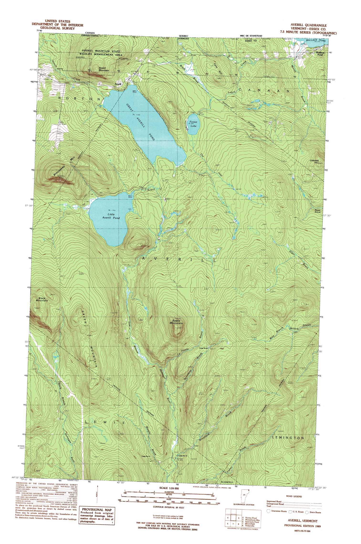
Averill Lake Topo Map Vermont
To zoom in, hover over the map of Averill Lake
USGS Topo Quad 44071h6 - 1:24,000 scale
| Topo Map Name: | Averill Lake |
| USGS Topo Quad ID: | 44071h6 |
| Print Size: | ca. 21 1/4" wide x 27" high |
| Southeast Coordinates: | 44.875° N latitude / 71.625° W longitude |
| Map Center Coordinates: | 44.9375° N latitude / 71.6875° W longitude |
| U.S. State: | VT |
| Filename: | o44071h6.jpg |
| Download Map JPG Image: | Averill Lake topo map 1:24,000 scale |
| Map Type: | Topographic |
| Topo Series: | 7.5´ |
| Map Scale: | 1:24,000 |
| Source of Map Images: | United States Geological Survey (USGS) |
| Alternate Map Versions: |
Averill VT 1989, updated 1989 Download PDF Buy paper map Averill VT 1989, updated 1989 Download PDF Buy paper map Averill VT 1995, updated 1999 Download PDF Buy paper map Averill VT 2012 Download PDF Buy paper map Averill VT 2015 Download PDF Buy paper map |
1:24,000 Topo Quads surrounding Averill Lake
Malvina |
||||
Pittsburg |
||||
Morgan Center |
Norton Pond |
Averill Lake |
Monadnock Mountain |
Lovering Mountain |
Island Pond |
Spectacle Pond |
Bloomfield |
Tinkerville |
Blue Mountain |
West Burke |
Seneca Mountain |
Maidstone Lake |
Stratford |
Percy Peaks |
> Back to 44071e1 at 1:100,000 scale
> Back to 44070a1 at 1:250,000 scale
> Back to U.S. Topo Maps home
Averill Lake topo map: Gazetteer
Averill Lake: Dams
Conway Dam elevation 621m 2037′Dam Number Five elevation 507m 1663′
Dam Number Four elevation 488m 1601′
Dam Number Six elevation 549m 1801′
Great Averill Pond Dam elevation 513m 1683′
Little Averill Dam elevation 549m 1801′
Averill Lake: Lakes
Forest Lake elevation 507m 1663′Little Averill Pond elevation 530m 1738′
Averill Lake: Populated Places
Averill elevation 515m 1689′Averill Lake: Reservoirs
Great Averill Pond elevation 513m 1683′Little Averill Lake elevation 549m 1801′
Averill Lake: Streams
Black Brook elevation 509m 1669′Brouillard Brook elevation 435m 1427′
La Pointe Brook elevation 507m 1663′
Murphy Brook elevation 432m 1417′
Spaulding Brook elevation 457m 1499′
The Inlet elevation 507m 1663′
Averill Lake: Summits
Black Mountain elevation 870m 2854′Brousseau Mountain elevation 840m 2755′
Canaan Hill elevation 682m 2237′
Cole Hill elevation 520m 1706′
Green Mountain elevation 825m 2706′
Sable Mountain elevation 850m 2788′
Averill Lake digital topo map on disk
Buy this Averill Lake topo map showing relief, roads, GPS coordinates and other geographical features, as a high-resolution digital map file on DVD:
Maine, New Hampshire, Rhode Island & Eastern Massachusetts
Buy digital topo maps: Maine, New Hampshire, Rhode Island & Eastern Massachusetts