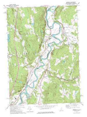
Newbury Topo Map New Hampshire
To zoom in, hover over the map of Newbury
USGS Topo Quad 44072a1 - 1:24,000 scale
| Topo Map Name: | Newbury |
| USGS Topo Quad ID: | 44072a1 |
| Print Size: | ca. 21 1/4" wide x 27" high |
| Southeast Coordinates: | 44° N latitude / 72° W longitude |
| Map Center Coordinates: | 44.0625° N latitude / 72.0625° W longitude |
| U.S. States: | NH, VT |
| Filename: | o44072a1.jpg |
| Download Map JPG Image: | Newbury topo map 1:24,000 scale |
| Map Type: | Topographic |
| Topo Series: | 7.5´ |
| Map Scale: | 1:24,000 |
| Source of Map Images: | United States Geological Survey (USGS) |
| Alternate Map Versions: |
Newbury VT 1973, updated 1975 Download PDF Buy paper map Newbury VT 2012 Download PDF Buy paper map Newbury VT 2015 Download PDF Buy paper map |
1:24,000 Topo Quads surrounding Newbury
> Back to 44072a1 at 1:100,000 scale
> Back to 44072a1 at 1:250,000 scale
> Back to U.S. Topo Maps home
Newbury topo map: Gazetteer
Newbury: Airports
Bradford Armory Heliport elevation 146m 479′Dean Memorial Airport elevation 171m 561′
Newbury: Benches
Sawyers Ledge elevation 209m 685′Newbury: Bends
The Oxbow elevation 118m 387′The Oxbow elevation 117m 383′
Newbury: Bridges
Bedell Covered Bridge elevation 116m 380′Bedell Covered Bridge elevation 120m 393′
Newbury: Dams
Blodgett Dam elevation 213m 698′Fish Pond Dam elevation 210m 688′
Walker Oliverian Stream Dam elevation 229m 751′
Newbury: Flats
Horse Meadow elevation 123m 403′Newbury: Islands
Howard Island elevation 129m 423′Newbury: Lakes
Halls Lake elevation 237m 777′Harriman Pond elevation 253m 830′
Wood Pond elevation 247m 810′
Newbury: Parks
Bayley Historic District elevation 129m 423′Newbury Historic District elevation 144m 472′
South Newbury Village Historic District elevation 141m 462′
Newbury: Populated Places
Haverhill elevation 191m 626′Newbury elevation 141m 462′
North Haverhill elevation 150m 492′
Peach Four Corners elevation 193m 633′
Pike elevation 226m 741′
South Newbury elevation 141m 462′
West Newbury elevation 279m 915′
Newbury: Rapids
Bailey Eddy elevation 130m 426′Newbury: Reservoirs
Blodgett Pond elevation 213m 698′Oliverian Brook elevation 229m 751′
The Fish Pond elevation 210m 688′
Newbury: Ridges
Catamount Ridge elevation 377m 1236′Newbury: Streams
Clark Brook elevation 116m 380′Halls Brook elevation 124m 406′
Harriman Brook elevation 121m 396′
Morris Brook elevation 181m 593′
Oliverian Brook elevation 116m 380′
Peach Brook elevation 168m 551′
Roaring Brook elevation 124m 406′
Newbury: Summits
Black Hill elevation 369m 1210′Leighton Hill elevation 357m 1171′
Pulaski Mountain elevation 281m 921′
Town Farm Hill elevation 297m 974′
Newbury: Swamps
Ox-Bow Meadows elevation 122m 400′Newbury digital topo map on disk
Buy this Newbury topo map showing relief, roads, GPS coordinates and other geographical features, as a high-resolution digital map file on DVD:
New York, Vermont, Connecticut & Western Massachusetts
Buy digital topo maps: New York, Vermont, Connecticut & Western Massachusetts


