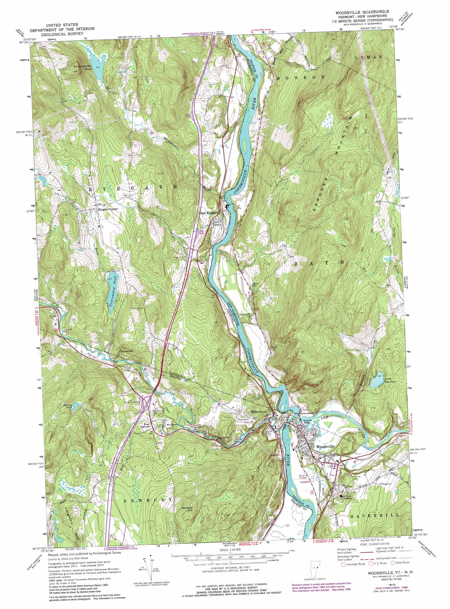
Woodsville Topo Map Vermont
To zoom in, hover over the map of Woodsville
USGS Topo Quad 44072b1 - 1:24,000 scale
| Topo Map Name: | Woodsville |
| USGS Topo Quad ID: | 44072b1 |
| Print Size: | ca. 21 1/4" wide x 27" high |
| Southeast Coordinates: | 44.125° N latitude / 72° W longitude |
| Map Center Coordinates: | 44.1875° N latitude / 72.0625° W longitude |
| U.S. States: | VT, NH |
| Filename: | o44072b1.jpg |
| Download Map JPG Image: | Woodsville topo map 1:24,000 scale |
| Map Type: | Topographic |
| Topo Series: | 7.5´ |
| Map Scale: | 1:24,000 |
| Source of Map Images: | United States Geological Survey (USGS) |
| Alternate Map Versions: |
Woodsville NH 1973, updated 1976 Download PDF Buy paper map Woodsville NH 1973, updated 1984 Download PDF Buy paper map Woodsville NH 1973, updated 1989 Download PDF Buy paper map Woodsville NH 1999, updated 2000 Download PDF Buy paper map Woodsville NH 2012 Download PDF Buy paper map Woodsville NH 2015 Download PDF Buy paper map |
1:24,000 Topo Quads surrounding Woodsville
Cabot |
Saint Johnsbury |
Concord |
Miles Pond |
|
Marshfield |
Barnet |
Lower Waterford |
Littleton |
|
Knox Mountain |
Groton |
Woodsville |
Lisbon |
Sugar Hill |
West Topsham |
East Corinth |
Newbury |
East Haverhill |
Mount Moosilauke |
Vershire |
Fairlee |
Piermont |
Warren |
Mount Kineo |
> Back to 44072a1 at 1:100,000 scale
> Back to 44072a1 at 1:250,000 scale
> Back to U.S. Topo Maps home
Woodsville topo map: Gazetteer
Woodsville: Bridges
Bath-Haverhill Bridge elevation 122m 400′Woodsville: Crossings
Interchange elevation 194m 636′Interchange 17 elevation 194m 636′
Woodsville: Dams
Ryegate Paper Company Dam elevation 122m 400′Woodsville Hydroelectric Dam elevation 139m 456′
Woodsville: Islands
No Mans Island elevation 123m 403′Woodsville: Lakes
Lake Gardner elevation 203m 666′Ticklenaked Pond elevation 270m 885′
Woodsville: Parks
Wells River Historic District elevation 130m 426′Woodsville: Populated Places
Boltonville elevation 200m 656′East Ryegate elevation 149m 488′
Ryegate Corner elevation 320m 1049′
Wells River elevation 131m 429′
Woodsville elevation 139m 456′
Woodsville: Post Offices
Wells River Post Office elevation 138m 452′Woodsville: Reservoirs
Ammonoosuc River Reservoir elevation 139m 456′Connecticut River Reservoir elevation 122m 400′
Lower Symes Pond elevation 247m 810′
Tenney Pond elevation 345m 1131′
Woodsville: Ridges
Gardner Mountain elevation 454m 1489′Woodsville: Streams
Ammonoosuc River elevation 122m 400′Burton Brook elevation 130m 426′
Hunt Mountain Brook elevation 122m 400′
Manchester Brook elevation 127m 416′
Scotch Burn elevation 273m 895′
Wells River elevation 122m 400′
Woodsville: Summits
Wallace Hill elevation 414m 1358′Woodsville digital topo map on disk
Buy this Woodsville topo map showing relief, roads, GPS coordinates and other geographical features, as a high-resolution digital map file on DVD:
New York, Vermont, Connecticut & Western Massachusetts
Buy digital topo maps: New York, Vermont, Connecticut & Western Massachusetts