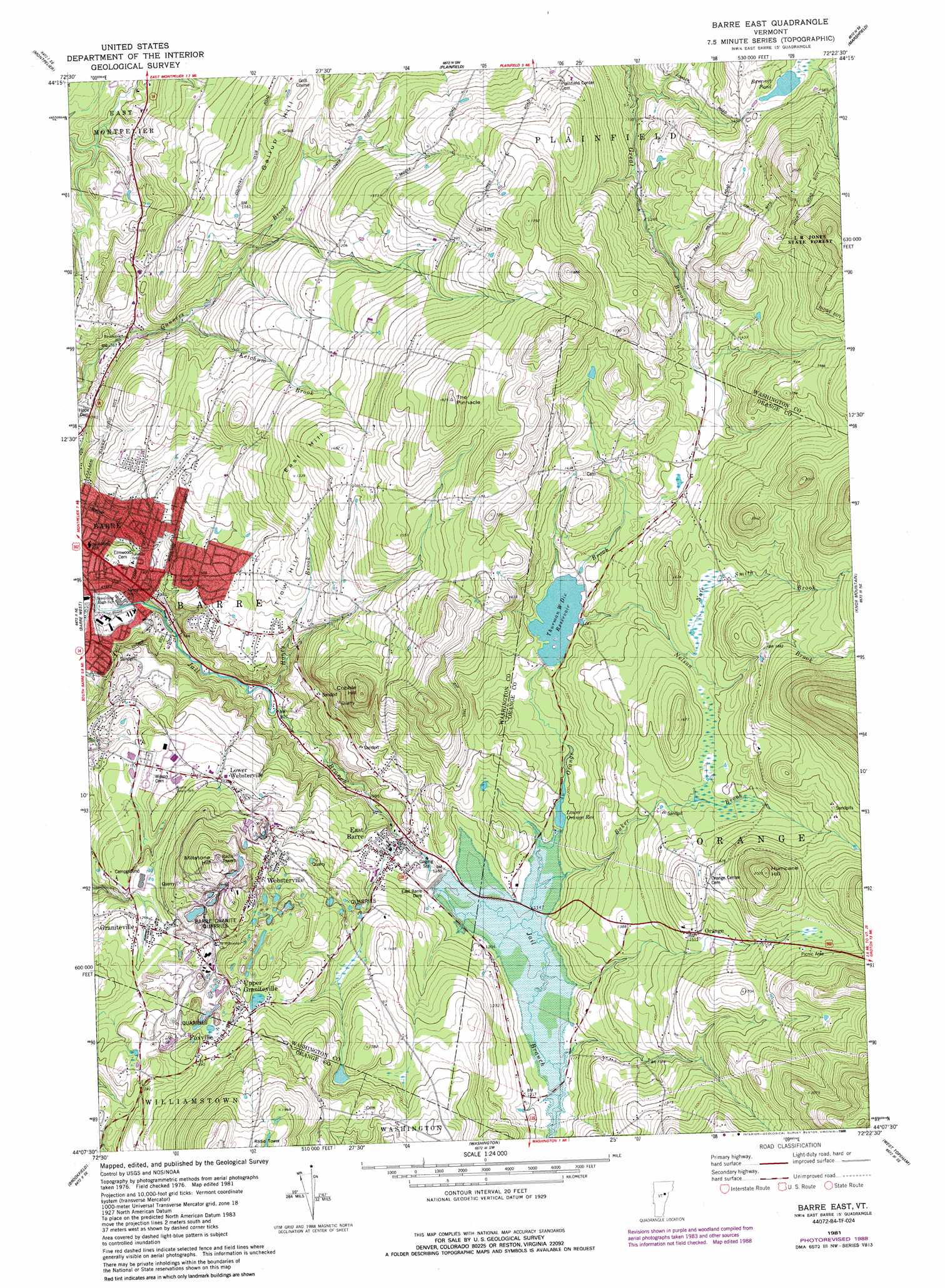
Barre East Topo Map Vermont
To zoom in, hover over the map of Barre East
USGS Topo Quad 44072b4 - 1:24,000 scale
| Topo Map Name: | Barre East |
| USGS Topo Quad ID: | 44072b4 |
| Print Size: | ca. 21 1/4" wide x 27" high |
| Southeast Coordinates: | 44.125° N latitude / 72.375° W longitude |
| Map Center Coordinates: | 44.1875° N latitude / 72.4375° W longitude |
| U.S. State: | VT |
| Filename: | o44072b4.jpg |
| Download Map JPG Image: | Barre East topo map 1:24,000 scale |
| Map Type: | Topographic |
| Topo Series: | 7.5´ |
| Map Scale: | 1:24,000 |
| Source of Map Images: | United States Geological Survey (USGS) |
| Alternate Map Versions: |
Barre East VT 1981, updated 1981 Download PDF Buy paper map Barre East VT 1981, updated 1988 Download PDF Buy paper map Barre East VT 2012 Download PDF Buy paper map Barre East VT 2015 Download PDF Buy paper map |
1:24,000 Topo Quads surrounding Barre East
Stowe |
Mount Worcester |
Woodbury |
Cabot |
|
Middlesex |
Montpelier |
Plainfield |
Marshfield |
|
Northfield |
Barre West |
Barre East |
Knox Mountain |
Groton |
Roxbury |
Brookfield |
Washington |
West Topsham |
East Corinth |
Randolph |
Randolph Center |
Chelsea |
Vershire |
Fairlee |
> Back to 44072a1 at 1:100,000 scale
> Back to 44072a1 at 1:250,000 scale
> Back to U.S. Topo Maps home
Barre East topo map: Gazetteer
Barre East: Dams
East Barre Dam elevation 357m 1171′Lower Orange Reservoir Dam elevation 361m 1184′
Thurman W. Dix Reservoir Dam elevation 387m 1269′
Barre East: Forests
Barre City Municipal Forest elevation 433m 1420′Barre Municipal Forest elevation 370m 1213′
Orange Town Forest elevation 538m 1765′
Barre East: Lakes
Bancroft Pond elevation 448m 1469′Wheeler Pond elevation 387m 1269′
Barre East: Mines
Ibarre Granite Quarries elevation 480m 1574′Rock of Ages Granite Quarry elevation 229m 751′
Barre East: Parks
Currier Park elevation 193m 633′Currier Park Historic District elevation 193m 633′
Robert Burns Memorial Statue elevation 199m 652′
Barre East: Populated Places
East Barre elevation 345m 1131′Foxville elevation 454m 1489′
Graniteville elevation 389m 1276′
Lower Websterville elevation 362m 1187′
Orange elevation 457m 1499′
Perkinsville elevation 425m 1394′
Upper Graniteville elevation 448m 1469′
Websterville elevation 403m 1322′
Wildersburg Common elevation 304m 997′
Barre East: Post Offices
East Barre Post Office elevation 342m 1122′Graniteville Post Office elevation 387m 1269′
Barre East: Reservoirs
East Barre Reservoir elevation 357m 1171′Lower Orange Reservoir elevation 361m 1184′
Orange Reservoir elevation 361m 1184′
Thurman W. Dix Reservoir elevation 387m 1269′
Barre East: Streams
Baker Brook elevation 347m 1138′Honey Brook elevation 239m 784′
Ketchum Brook elevation 256m 839′
Nate Smith Brook elevation 438m 1437′
Nelson Brook elevation 388m 1272′
Orange Brook elevation 345m 1131′
Barre East: Summits
Cobble Hill elevation 533m 1748′East Hill elevation 452m 1482′
Gallup Hill elevation 385m 1263′
Hurricane Hill elevation 612m 2007′
Millstone Hill elevation 527m 1729′
The Pinnacle elevation 550m 1804′
Trow Hill elevation 367m 1204′
Barre East digital topo map on disk
Buy this Barre East topo map showing relief, roads, GPS coordinates and other geographical features, as a high-resolution digital map file on DVD:
New York, Vermont, Connecticut & Western Massachusetts
Buy digital topo maps: New York, Vermont, Connecticut & Western Massachusetts