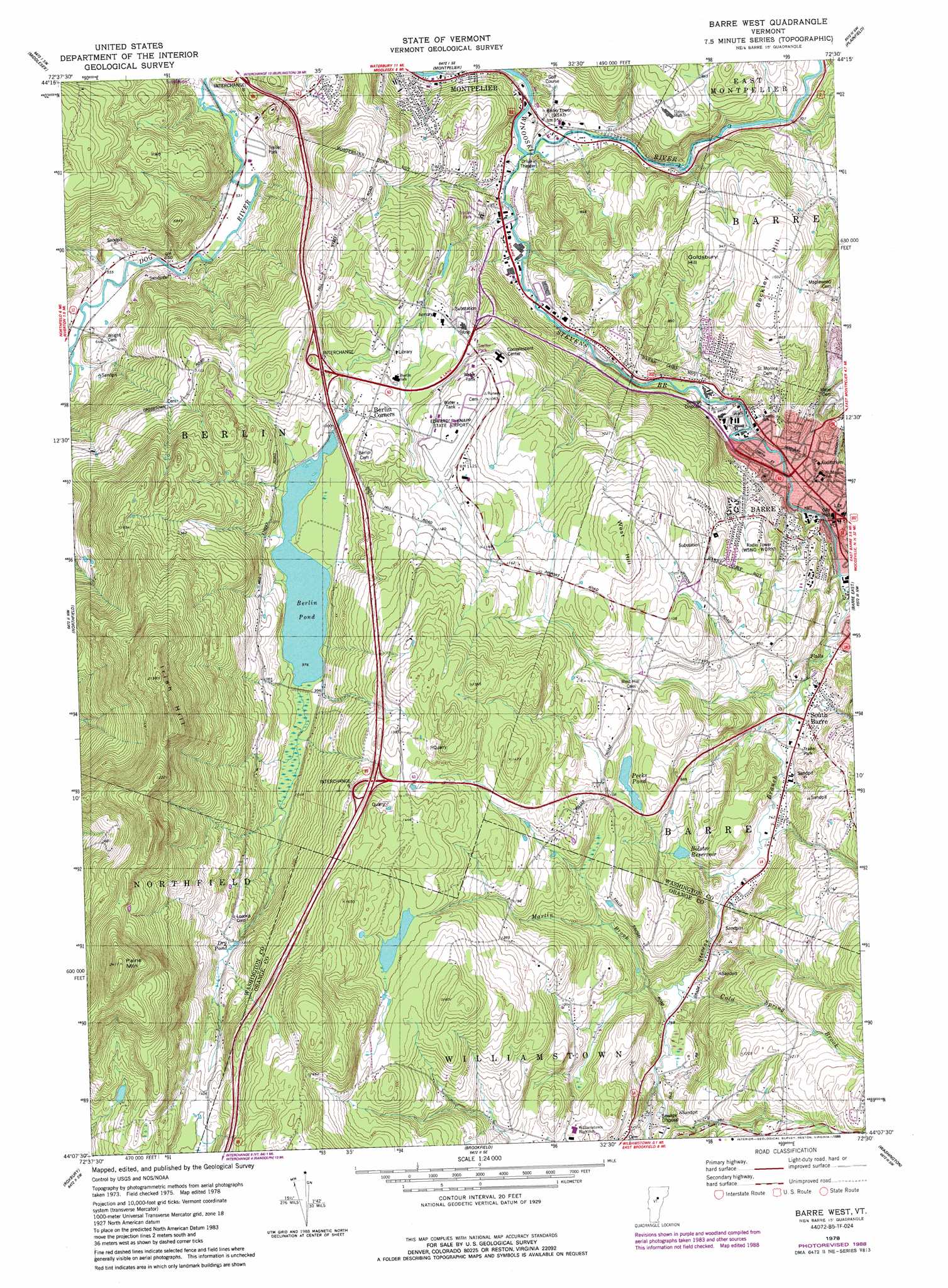
Barre West Topo Map Vermont
To zoom in, hover over the map of Barre West
USGS Topo Quad 44072b5 - 1:24,000 scale
| Topo Map Name: | Barre West |
| USGS Topo Quad ID: | 44072b5 |
| Print Size: | ca. 21 1/4" wide x 27" high |
| Southeast Coordinates: | 44.125° N latitude / 72.5° W longitude |
| Map Center Coordinates: | 44.1875° N latitude / 72.5625° W longitude |
| U.S. State: | VT |
| Filename: | o44072b5.jpg |
| Download Map JPG Image: | Barre West topo map 1:24,000 scale |
| Map Type: | Topographic |
| Topo Series: | 7.5´ |
| Map Scale: | 1:24,000 |
| Source of Map Images: | United States Geological Survey (USGS) |
| Alternate Map Versions: |
Barre West VT 1978, updated 1979 Download PDF Buy paper map Barre West VT 1978, updated 1988 Download PDF Buy paper map Barre West VT 1978, updated 1988 Download PDF Buy paper map Barre West VT 2012 Download PDF Buy paper map Barre West VT 2015 Download PDF Buy paper map |
1:24,000 Topo Quads surrounding Barre West
Bolton Mountain |
Stowe |
Mount Worcester |
Woodbury |
Cabot |
Waterbury |
Middlesex |
Montpelier |
Plainfield |
Marshfield |
Waitsfield |
Northfield |
Barre West |
Barre East |
Knox Mountain |
Warren |
Roxbury |
Brookfield |
Washington |
West Topsham |
Hancock |
Randolph |
Randolph Center |
Chelsea |
Vershire |
> Back to 44072a1 at 1:100,000 scale
> Back to 44072a1 at 1:250,000 scale
> Back to U.S. Topo Maps home
Barre West topo map: Gazetteer
Barre West: Airports
Berlin Armory Heliport elevation 289m 948′Edward F Knapp State Airport elevation 346m 1135′
Barre West: Crossings
Interchange 6 elevation 425m 1394′Interchange 7 elevation 341m 1118′
Barre West: Dams
Berlin Pond Dam elevation 297m 974′Montpelier Number Four Dam elevation 192m 629′
Barre West: Forests
Barre City Municipal Forest elevation 319m 1046′Barre Municipal Forest elevation 294m 964′
Berlin Municipal Forest elevation 348m 1141′
Montpelier Municipal Forest elevation 352m 1154′
Williamstown Municipal Forest elevation 441m 1446′
Barre West: Lakes
Dry Pond elevation 365m 1197′Pecks Pond elevation 311m 1020′
Barre West: Parks
Barre Downtown Historic District elevation 190m 623′Vermont City Park elevation 195m 639′
Barre West: Populated Places
Barre elevation 194m 636′Berlin Corners elevation 313m 1026′
South Barre elevation 225m 738′
Barre West: Post Offices
Barre Post Office elevation 190m 623′Barre West: Reservoirs
Berlin Pond elevation 297m 974′Bolster Reservoir elevation 256m 839′
Barre West: Streams
Cold Spring Brook elevation 229m 751′Gunners Brook elevation 185m 606′
Jail Branch elevation 203m 666′
Martin Brook elevation 224m 734′
Pond Brook elevation 164m 538′
Stevens Branch elevation 167m 547′
Barre West: Summits
Beckley Hill elevation 321m 1053′Goldsbury Hill elevation 308m 1010′
Irish Hill elevation 632m 2073′
Paine Mountain elevation 726m 2381′
West Hill elevation 405m 1328′
Barre West digital topo map on disk
Buy this Barre West topo map showing relief, roads, GPS coordinates and other geographical features, as a high-resolution digital map file on DVD:
New York, Vermont, Connecticut & Western Massachusetts
Buy digital topo maps: New York, Vermont, Connecticut & Western Massachusetts