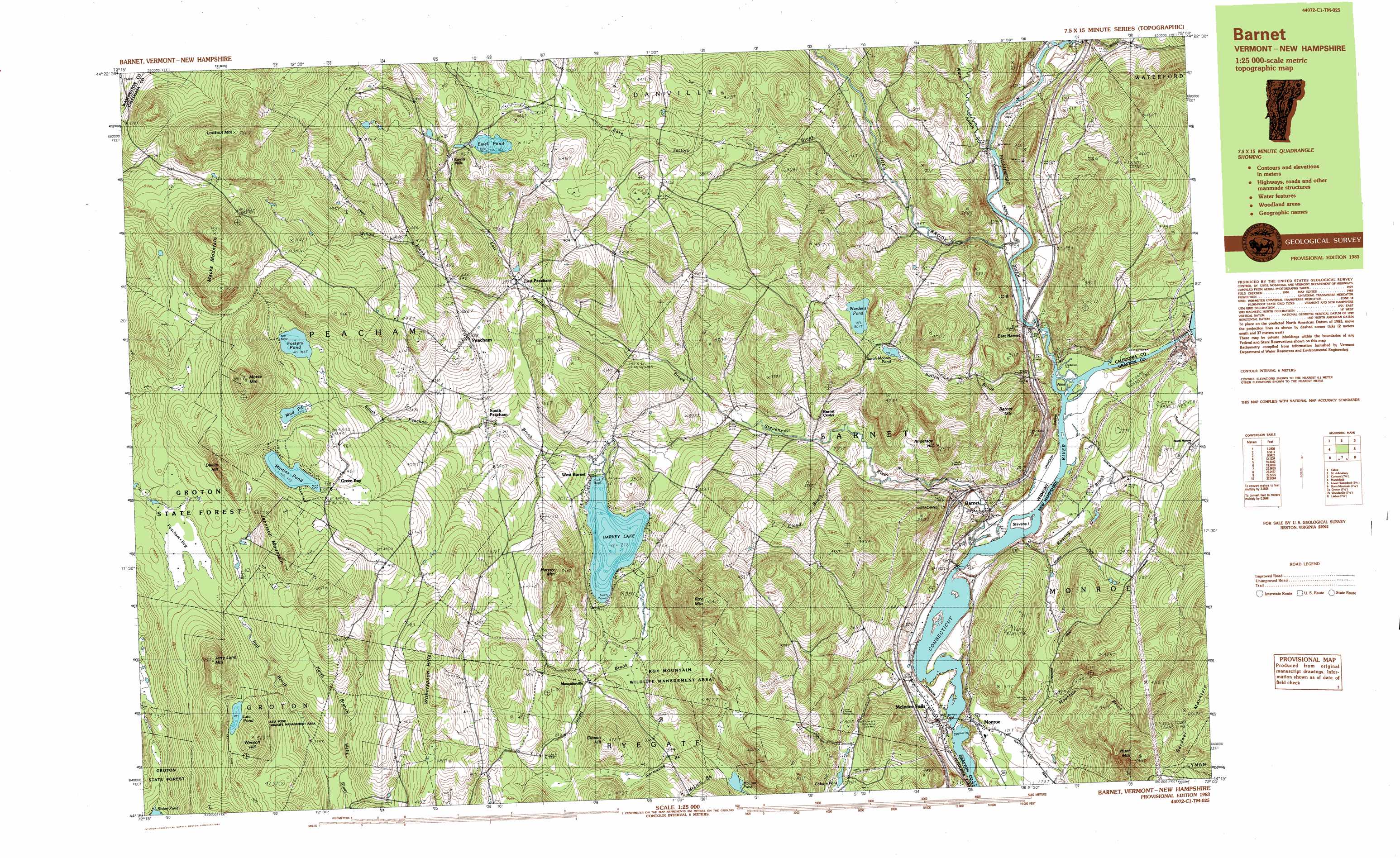
Barnet Topo Map Vermont
To zoom in, hover over the map of Barnet
USGS Topo Quad 44072c1 - 1:25,000 scale
| Topo Map Name: | Barnet |
| USGS Topo Quad ID: | 44072c1 |
| Print Size: | ca. 39" wide x 24" high |
| Southeast Coordinates: | 44.25° N latitude / 72° W longitude |
| Map Center Coordinates: | 44.3125° N latitude / 72.125° W longitude |
| U.S. States: | VT, NH |
| Filename: | k44072c1.jpg |
| Download Map JPG Image: | Barnet topo map 1:25,000 scale |
| Map Type: | Topographic |
| Topo Series: | 7.5´x15´ |
| Map Scale: | 1:25,000 |
| Source of Map Images: | United States Geological Survey (USGS) |
| Alternate Map Versions: |
Barnet VT 1983, updated 1983 Download PDF Buy paper map |
1:24,000 Topo Quads surrounding Barnet
Caspian Lake |
Stannard |
Lyndonville |
Burke Mountain |
Gallup Mills |
Cabot |
Saint Johnsbury |
Concord |
Miles Pond |
|
Marshfield |
Barnet |
Lower Waterford |
Littleton |
|
Knox Mountain |
Groton |
Woodsville |
Lisbon |
Sugar Hill |
West Topsham |
East Corinth |
Newbury |
East Haverhill |
Mount Moosilauke |
> Back to 44072a1 at 1:100,000 scale
> Back to 44072a1 at 1:250,000 scale
> Back to U.S. Topo Maps home
Barnet topo map: Gazetteer
Barnet: Crossings
Interchange 18 elevation 199m 652′Barnet: Dams
Comerford Station Dam elevation 139m 456′Ewell Pond Dam elevation 400m 1312′
Fifteen-Mile Fall Dam elevation 151m 495′
Harveys Lake Dam elevation 272m 892′
Martins Pond Dam elevation 492m 1614′
McIndoes Station Dam elevation 425m 1394′
Tyler Tree Farm Dam elevation 195m 639′
Barnet: Forests
Barnet Municipal Forest elevation 276m 905′Peacham Fire District Forest elevation 566m 1856′
Peacham Municipal Forest elevation 585m 1919′
Barnet: Islands
Gleason Island elevation 140m 459′Nine Island elevation 173m 567′
Stevens Island elevation 138m 452′
Barnet: Lakes
Coburn Pond elevation 245m 803′Fosters Pond elevation 465m 1525′
Jewett Pond elevation 287m 941′
Levi Pond elevation 499m 1637′
McLam Pond elevation 246m 807′
Mud Pond elevation 473m 1551′
Sarah Moores Pond elevation 296m 971′
Wardens Pond elevation 301m 987′
Barnet: Parks
Levi Pond Wildlife Management Area elevation 520m 1706′Ricker Recreational Area elevation 324m 1062′
Barnet: Populated Places
Barnet elevation 174m 570′East Barnet Inwood Station elevation 161m 528′
East Peacham elevation 297m 974′
Ewells Mills elevation 394m 1292′
Green Bay elevation 474m 1555′
McIndoe Falls elevation 146m 479′
Monroe elevation 161m 528′
Mosquitoville elevation 305m 1000′
Peacham elevation 390m 1279′
South Peacham elevation 308m 1010′
West Barnet elevation 272m 892′
Barnet: Post Offices
Barnet Post Office elevation 169m 554′Monroe Post Office elevation 172m 564′
Barnet: Ranges
Witherspoon Hills elevation 540m 1771′Barnet: Reservoirs
Connecticut River Reservoir elevation 139m 456′Ewell Pond elevation 400m 1312′
Harvey Lake elevation 272m 892′
Martins Pond elevation 492m 1614′
Roaring Brook Reservoir elevation 195m 639′
Barnet: Streams
Cloud Brook elevation 205m 672′East Peacham Brook elevation 231m 757′
Jewett Brook elevation 280m 918′
Joes Brook elevation 144m 472′
McLam Brook elevation 246m 807′
Passumpsic River elevation 138m 452′
Peacham Hollow Brook elevation 239m 784′
Rake Factory Brook elevation 192m 629′
Simpson Brook elevation 161m 528′
Smith Brook elevation 143m 469′
South Peacham Brook elevation 233m 764′
Stevens River elevation 132m 433′
Sutton Brook elevation 138m 452′
Water Andric elevation 148m 485′
Wormwood Brook elevation 246m 807′
Barnet: Summits
Anderson Hill elevation 375m 1230′Barnet Mountain elevation 368m 1207′
Devils Hill elevation 599m 1965′
Harvey Mountain elevation 385m 1263′
Hunt Mountain elevation 590m 1935′
Jennison Mountain elevation 574m 1883′
Jerry Lund Mountain elevation 624m 2047′
Lookout Mountain elevation 762m 2500′
Macks Mountain elevation 735m 2411′
Morrison Hill elevation 428m 1404′
Morrison Hill elevation 429m 1407′
Morse Mountain elevation 692m 2270′
Roy Mountain elevation 635m 2083′
Wesson Hill elevation 546m 1791′
Barnet: Swamps
Peacham Bog elevation 464m 1522′Barnet: Trails
Peacham Bog Trail elevation 466m 1528′Barnet: Valleys
Smutty Hollow elevation 170m 557′Barnet digital topo map on disk
Buy this Barnet topo map showing relief, roads, GPS coordinates and other geographical features, as a high-resolution digital map file on DVD:
New York, Vermont, Connecticut & Western Massachusetts
Buy digital topo maps: New York, Vermont, Connecticut & Western Massachusetts