Lyndonville Topo Map Vermont
To zoom in, hover over the map of Lyndonville
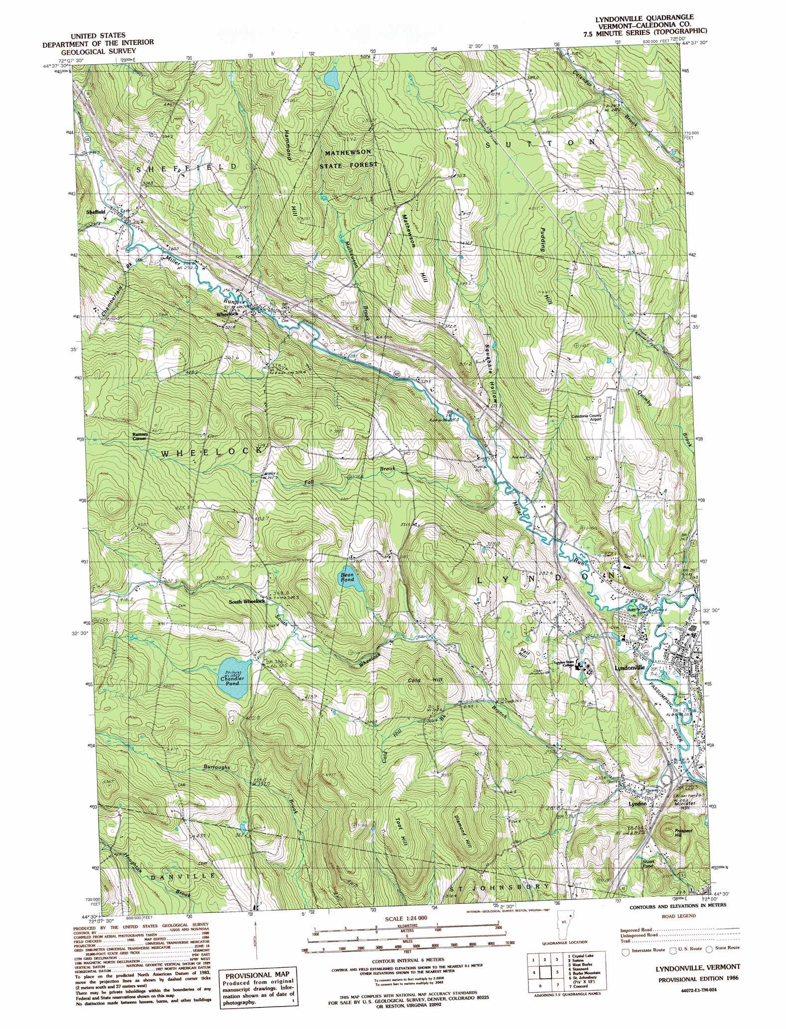
USGS Topo Quad 44072e1 - 1:24,000 scale
| Topo Map Name: | Lyndonville |
| USGS Topo Quad ID: | 44072e1 |
| Print Size: | ca. 21 1/4" wide x 27" high |
| Southeast Coordinates: | 44.5° N latitude / 72° W longitude |
| Map Center Coordinates: | 44.5625° N latitude / 72.0625° W longitude |
| U.S. State: | VT |
| Filename: | o44072e1.jpg |
| Download Map JPG Image: | Lyndonville topo map 1:24,000 scale |
| Map Type: | Topographic |
| Topo Series: | 7.5´ |
| Map Scale: | 1:24,000 |
| Source of Map Images: | United States Geological Survey (USGS) |
| Alternate Map Versions: |
Lyndonville VT 1986, updated 1987 Download PDF Buy paper map Lyndonville VT 1986, updated 1987 Download PDF Buy paper map Lyndonville VT 2012 Download PDF Buy paper map Lyndonville VT 2015 Download PDF Buy paper map |
1:24,000 Topo Quads surrounding Lyndonville
Irasburg |
Orleans |
Westmore |
Island Pond |
Spectacle Pond |
Craftsbury |
Crystal Lake |
Sutton |
West Burke |
Seneca Mountain |
Caspian Lake |
Stannard |
Lyndonville |
Burke Mountain |
Gallup Mills |
Cabot |
Saint Johnsbury |
Concord |
Miles Pond |
|
Marshfield |
Barnet |
Lower Waterford |
Littleton |
> Back to 44072e1 at 1:100,000 scale
> Back to 44072a1 at 1:250,000 scale
> Back to U.S. Topo Maps home
Lyndonville topo map: Gazetteer
Lyndonville: Airports
Caledonia County Airport elevation 350m 1148′Lyndonville: Bridges
Bradley Covered Bridge elevation 213m 698′Centre Covered Bridge elevation 214m 702′
Chamberlin Mill Covered Bridge elevation 219m 718′
Old Schoolhouse Bridge elevation 228m 748′
Lyndonville: Crossings
Interchange 23 elevation 232m 761′Interchange 24 elevation 223m 731′
Lyndonville: Dams
Chandler Pond Dam elevation 383m 1256′Institute Pond Dam elevation 247m 810′
Lyndonville: Forests
Lyndon Municipal Forest elevation 299m 980′Mathewson State Forest elevation 483m 1584′
Lyndonville: Lakes
Bean Pond elevation 362m 1187′Stuart Pond elevation 260m 853′
Lyndonville: Parks
Powers Park elevation 211m 692′Lyndonville: Populated Places
Lyndon elevation 234m 767′Lyndon Center elevation 218m 715′
Lyndon Center elevation 216m 708′
Lyndonville elevation 220m 721′
Ramsey Corner elevation 466m 1528′
Sheffield elevation 271m 889′
Wheelock elevation 246m 807′
Lyndonville: Post Offices
Lyndon Center Post Office elevation 216m 708′Lyndonville Post Office elevation 221m 725′
Lyndonville: Reservoirs
Chandler Pond elevation 383m 1256′Institute Pond elevation 247m 810′
Lyndonville: Streams
Chamberlain Brook elevation 260m 853′Cold Hill Brook elevation 259m 849′
Fall Brook elevation 215m 705′
Mathewson Brook elevation 222m 728′
Miller Run elevation 214m 702′
Oregon Brook elevation 337m 1105′
South Wheelock Branch elevation 219m 718′
Square Brook elevation 299m 980′
Lyndonville: Summits
Cold Hill elevation 398m 1305′Diamond Hill elevation 511m 1676′
Hammond Hill elevation 500m 1640′
Mathewson Hill elevation 508m 1666′
Minister Hill elevation 288m 944′
Prospect Hill elevation 334m 1095′
Pudding Hill elevation 461m 1512′
Toot Hill elevation 494m 1620′
Vail Hill elevation 354m 1161′
Lyndonville: Valleys
Squabble Hollow elevation 214m 702′Lyndonville digital topo map on disk
Buy this Lyndonville topo map showing relief, roads, GPS coordinates and other geographical features, as a high-resolution digital map file on DVD:
New York, Vermont, Connecticut & Western Massachusetts
Buy digital topo maps: New York, Vermont, Connecticut & Western Massachusetts