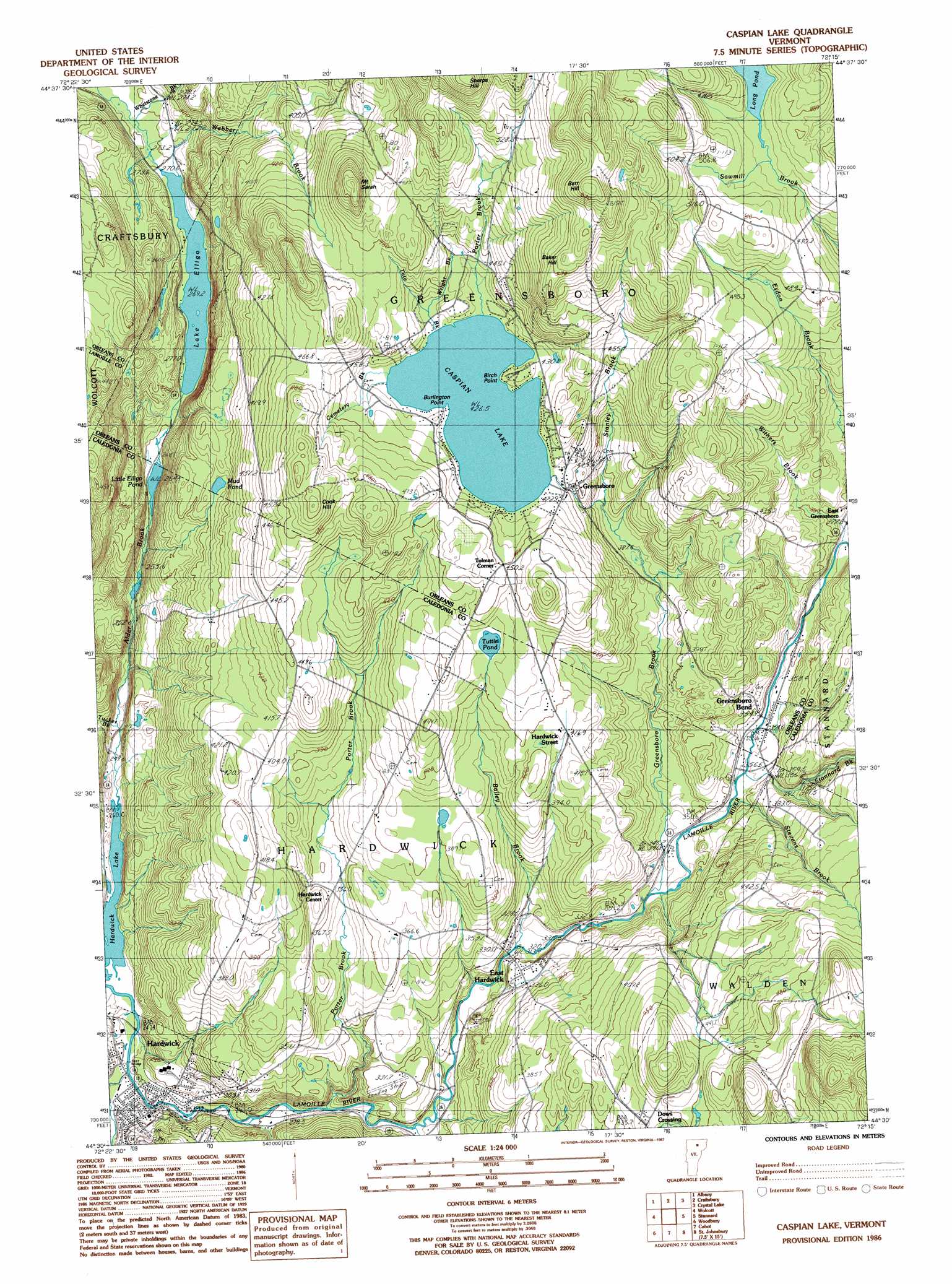
Caspian Lake Topo Map Vermont
To zoom in, hover over the map of Caspian Lake
USGS Topo Quad 44072e3 - 1:24,000 scale
| Topo Map Name: | Caspian Lake |
| USGS Topo Quad ID: | 44072e3 |
| Print Size: | ca. 21 1/4" wide x 27" high |
| Southeast Coordinates: | 44.5° N latitude / 72.25° W longitude |
| Map Center Coordinates: | 44.5625° N latitude / 72.3125° W longitude |
| U.S. State: | VT |
| Filename: | o44072e3.jpg |
| Download Map JPG Image: | Caspian Lake topo map 1:24,000 scale |
| Map Type: | Topographic |
| Topo Series: | 7.5´ |
| Map Scale: | 1:24,000 |
| Source of Map Images: | United States Geological Survey (USGS) |
| Alternate Map Versions: |
Caspian Lake VT 1986, updated 1987 Download PDF Buy paper map Caspian Lake VT 1986, updated 1987 Download PDF Buy paper map Caspian Lake VT 2012 Download PDF Buy paper map Caspian Lake VT 2015 Download PDF Buy paper map |
1:24,000 Topo Quads surrounding Caspian Lake
Hazens Notch |
Lowell |
Irasburg |
Orleans |
Westmore |
Eden |
Albany |
Craftsbury |
Crystal Lake |
Sutton |
Morrisville |
W0Lcott |
Caspian Lake |
Stannard |
Lyndonville |
Mount Worcester |
Woodbury |
Cabot |
Saint Johnsbury |
|
Montpelier |
Plainfield |
Marshfield |
Barnet |
> Back to 44072e1 at 1:100,000 scale
> Back to 44072a1 at 1:250,000 scale
> Back to U.S. Topo Maps home
Caspian Lake topo map: Gazetteer
Caspian Lake: Capes
Birch Point elevation 434m 1423′Burlington Point elevation 431m 1414′
Caspian Lake: Dams
Caspian Lake Dam elevation 427m 1400′Caspian Lake: Forests
East Hardwich Fire District Forest elevation 384m 1259′Hardwick Union Municipal Forest elevation 299m 980′
Hardwick Village Forest elevation 308m 1010′
Caspian Lake: Lakes
Lake Elligo elevation 271m 889′Little Elligo Pond elevation 266m 872′
Mud Pond elevation 370m 1213′
Tuttle Pond elevation 428m 1404′
Caspian Lake: Parks
Bayley-Hazen Military Monument elevation 456m 1496′Bayley-Hazen Military Road Monument elevation 417m 1368′
Downtown Hardwick Village Historic District elevation 260m 853′
Hardwick Street Historic District elevation 414m 1358′
Caspian Lake: Populated Places
Campbells Corner elevation 458m 1502′Dows Crossing elevation 427m 1400′
East Greensboro elevation 383m 1256′
East Hardwick elevation 329m 1079′
Greensboro elevation 425m 1394′
Greensboro Bend elevation 357m 1171′
Hardwick elevation 249m 816′
Hardwick Center elevation 356m 1167′
Hardwick Street elevation 421m 1381′
North Walden elevation 511m 1676′
Tolman Corner elevation 449m 1473′
Caspian Lake: Post Offices
Hardwick Post Office elevation 256m 839′Caspian Lake: Reservoirs
Caspian Lake elevation 427m 1400′Hardwick Center Pond elevation 392m 1286′
Caspian Lake: Streams
Alder Brook elevation 241m 790′Bailey Brook elevation 317m 1040′
Cemetery Brook elevation 429m 1407′
Cooper Brook elevation 247m 810′
Greensboro Brook elevation 338m 1108′
Haynesville Brook elevation 290m 951′
Porter Brook elevation 277m 908′
Porter Brook elevation 431m 1414′
Stanley Brook elevation 378m 1240′
Stannard Brook elevation 353m 1158′
Stevens Brook elevation 348m 1141′
Tate Brook elevation 431m 1414′
Tucker Brook elevation 242m 793′
Whetstone Brook elevation 266m 872′
Withers Brook elevation 373m 1223′
Wright Brook elevation 431m 1414′
Caspian Lake: Summits
Baker Hill elevation 587m 1925′Barr Hill elevation 644m 2112′
Cook Hill elevation 521m 1709′
Mount Sarah elevation 558m 1830′
Sharps Hill elevation 639m 2096′
Caspian Lake: Swamps
Taylor Swamp elevation 483m 1584′Caspian Lake digital topo map on disk
Buy this Caspian Lake topo map showing relief, roads, GPS coordinates and other geographical features, as a high-resolution digital map file on DVD:
New York, Vermont, Connecticut & Western Massachusetts
Buy digital topo maps: New York, Vermont, Connecticut & Western Massachusetts