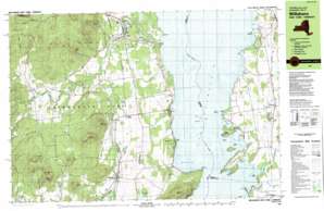
Charlotte Topo Map Vermont
To zoom in, hover over the map of Charlotte
USGS Topo Quad 44073c3 - 1:25,000 scale
| Topo Map Name: | Charlotte |
| USGS Topo Quad ID: | 44073c3 |
| Print Size: | ca. 39" wide x 24" high |
| Southeast Coordinates: | 44.25° N latitude / 73.25° W longitude |
| Map Center Coordinates: | 44.3125° N latitude / 73.375° W longitude |
| U.S. States: | VT, NY |
| Filename: | k44073c3.jpg |
| Download Map JPG Image: | Charlotte topo map 1:25,000 scale |
| Map Type: | Topographic |
| Topo Series: | 7.5´x15´ |
| Map Scale: | 1:25,000 |
| Source of Map Images: | United States Geological Survey (USGS) |
| Alternate Map Versions: |
Willsboro NY 1980, updated 1980 Download PDF Buy paper map Willsboro NY 1999, updated 2000 Download PDF Buy paper map |
1:24,000 Topo Quads surrounding Charlotte
> Back to 44073a1 at 1:100,000 scale
> Back to 44072a1 at 1:250,000 scale
> Back to U.S. Topo Maps home
Charlotte topo map: Gazetteer
Charlotte: Airports
E A Deeds Farm Airport elevation 36m 118′Essex Boatworks Seaplane Base elevation 29m 95′
Richter Aero Airport elevation 92m 301′
Charlotte: Bars
Meach Cove elevation 29m 95′Charlotte: Bays
Converse Bay elevation 29m 95′Grog Harbor elevation 29m 95′
McNeil Cove elevation 29m 95′
Town Farm Bay elevation 29m 95′
Twilight Bay elevation 29m 95′
Whallon Bay elevation 29m 95′
Charlotte: Bridges
Holmes Creek Covered Bridge elevation 29m 95′Charlotte: Capes
Boquet River Point elevation 29m 95′Cannon Point elevation 29m 95′
Hill Point elevation 38m 124′
Long Point elevation 35m 114′
Split Rock Point elevation 31m 101′
Thompsons Point elevation 38m 124′
Wings Point elevation 35m 114′
Charlotte: Crossings
Essex Ferry elevation 29m 95′Essex Ferry elevation 29m 95′
Charlotte: Islands
Cedar Island elevation 29m 95′Dean Island elevation 29m 95′
Garden Island elevation 43m 141′
Gardiner Island elevation 29m 95′
Meach Island elevation 30m 98′
Picket Island elevation 29m 95′
Sloop Island elevation 29m 95′
Charlotte: Parks
Charlotte Center Historic District elevation 77m 252′Charlotte: Pillars
Flat Rock elevation 37m 121′Charlotte: Populated Places
Boquet elevation 92m 301′Cedar Beach elevation 41m 134′
Charlotte elevation 51m 167′
Craterclub elevation 64m 209′
Essex elevation 38m 124′
Reber elevation 116m 380′
Whallonsburg elevation 86m 282′
Willsboro elevation 68m 223′
Charlotte: Post Offices
Charlotte Post Office elevation 82m 269′Charlotte: Streams
Beaver Brook elevation 75m 246′Boquet River elevation 29m 95′
Brandywine Brook elevation 29m 95′
Cold Brook elevation 101m 331′
Holmes Creek elevation 29m 95′
Kimball Brook elevation 29m 95′
North Branch Boquet River elevation 54m 177′
Pringle Brook elevation 40m 131′
Spruce Mill Brook elevation 102m 334′
Thorp Brook elevation 29m 95′
Charlotte: Summits
Barber Hill elevation 117m 383′Ferguson Mountain elevation 314m 1030′
North Boquet Mountain elevation 307m 1007′
Payne Mountain elevation 353m 1158′
South Boquet Mountain elevation 366m 1200′
Sprig Mountain elevation 264m 866′
Whippie Mountain elevation 267m 875′
Charlotte: Swamps
Webb Royce Swamp elevation 94m 308′Charlotte digital topo map on disk
Buy this Charlotte topo map showing relief, roads, GPS coordinates and other geographical features, as a high-resolution digital map file on DVD:
New York, Vermont, Connecticut & Western Massachusetts
Buy digital topo maps: New York, Vermont, Connecticut & Western Massachusetts


