Juniper Island Topo Map Vermont
To zoom in, hover over the map of Juniper Island
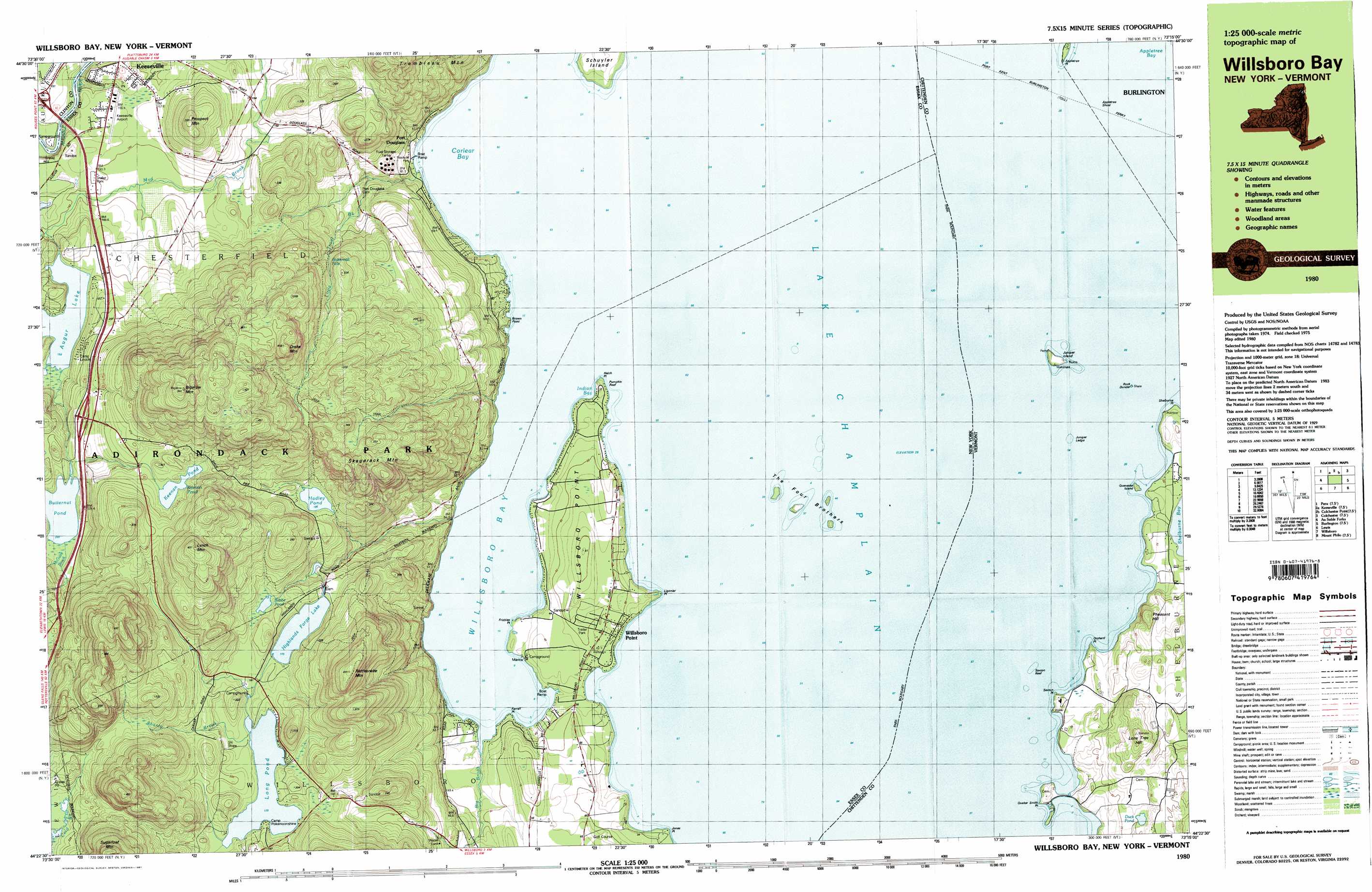
USGS Topo Quad 44073d3 - 1:25,000 scale
| Topo Map Name: | Juniper Island |
| USGS Topo Quad ID: | 44073d3 |
| Print Size: | ca. 39" wide x 24" high |
| Southeast Coordinates: | 44.375° N latitude / 73.25° W longitude |
| Map Center Coordinates: | 44.4375° N latitude / 73.375° W longitude |
| U.S. States: | VT, NY |
| Filename: | k44073d3.jpg |
| Download Map JPG Image: | Juniper Island topo map 1:25,000 scale |
| Map Type: | Topographic |
| Topo Series: | 7.5´x15´ |
| Map Scale: | 1:25,000 |
| Source of Map Images: | United States Geological Survey (USGS) |
| Alternate Map Versions: |
Willsboro Bay VT 1980, updated 1981 Download PDF Buy paper map Willsboro Bay VT 1980, updated 1981 Download PDF Buy paper map |
1:24,000 Topo Quads surrounding Juniper Island
Morrisonville |
Plattsburgh |
South Hero |
Georgia Plains |
Milton |
Peru |
Keeseville |
Colchester Point |
Colchester |
Essex Center |
Clintonville |
Juniper Island |
Burlington |
Essex Junction |
|
Lewis |
Charlotte |
Mount Philo |
Hinesburg |
|
Elizabethtown |
Vergennes West |
Vergennes East |
Bristol |
> Back to 44073a1 at 1:100,000 scale
> Back to 44072a1 at 1:250,000 scale
> Back to U.S. Topo Maps home
Juniper Island topo map: Gazetteer
Juniper Island: Airports
Shelburne Farms Airport elevation 39m 127′Juniper Island: Bars
Appletree Shoal elevation 29m 95′Juniper Ledge elevation 29m 95′
Pumpkin Reef elevation 29m 95′
Quaker Smith Reef elevation 29m 95′
Rock Dunder elevation 29m 95′
Saxton Reef elevation 29m 95′
Schuyler Reef elevation 29m 95′
Juniper Island: Bays
Appletree Bay elevation 29m 95′Corlaer Bay elevation 29m 95′
Indian Bay elevation 29m 95′
Willsboro Bay elevation 29m 95′
Juniper Island: Capes
Appletree Point elevation 31m 101′Brown Point elevation 33m 108′
Frisbies Point elevation 31m 101′
Hatch Point elevation 39m 127′
Jones Point elevation 32m 104′
Ligonier Point elevation 35m 114′
Orchard Point elevation 33m 108′
Quaker Smith Point elevation 42m 137′
Saxton Point elevation 42m 137′
Shelburne Point elevation 35m 114′
Willsboro Point elevation 46m 150′
Juniper Island: Falls
Buttermilk Falls elevation 186m 610′Juniper Island: Islands
Juniper Island elevation 38m 124′Queneska Island elevation 29m 95′
Schuyler Island elevation 39m 127′
The Four Brothers elevation 29m 95′
Juniper Island: Lakes
Butternut Pond elevation 203m 666′Duck Pond elevation 53m 173′
Florence Pond elevation 183m 600′
Hadley Pond elevation 186m 610′
Highlands Forge Lake elevation 173m 567′
Keenan Pond elevation 258m 846′
Long Pond elevation 179m 587′
Juniper Island: Populated Places
Port Douglass elevation 42m 137′Willsboro Point elevation 45m 147′
Juniper Island: Streams
Big Brook elevation 29m 95′Little Trout Brook elevation 30m 98′
McGuire Brook elevation 203m 666′
Shanty Brook elevation 181m 593′
Juniper Island: Summits
Bigelow Mountain elevation 501m 1643′Drake Mountain elevation 401m 1315′
Lone Tree Hill elevation 110m 360′
Lynch Mountain elevation 425m 1394′
Pheasant Hill elevation 86m 282′
Prospect Mountain elevation 276m 905′
Rattlesnake Mountain elevation 394m 1292′
Sugarloaf Mountain elevation 440m 1443′
Juniper Island digital topo map on disk
Buy this Juniper Island topo map showing relief, roads, GPS coordinates and other geographical features, as a high-resolution digital map file on DVD:
New York, Vermont, Connecticut & Western Massachusetts
Buy digital topo maps: New York, Vermont, Connecticut & Western Massachusetts