Wilmington Topo Map New York
To zoom in, hover over the map of Wilmington
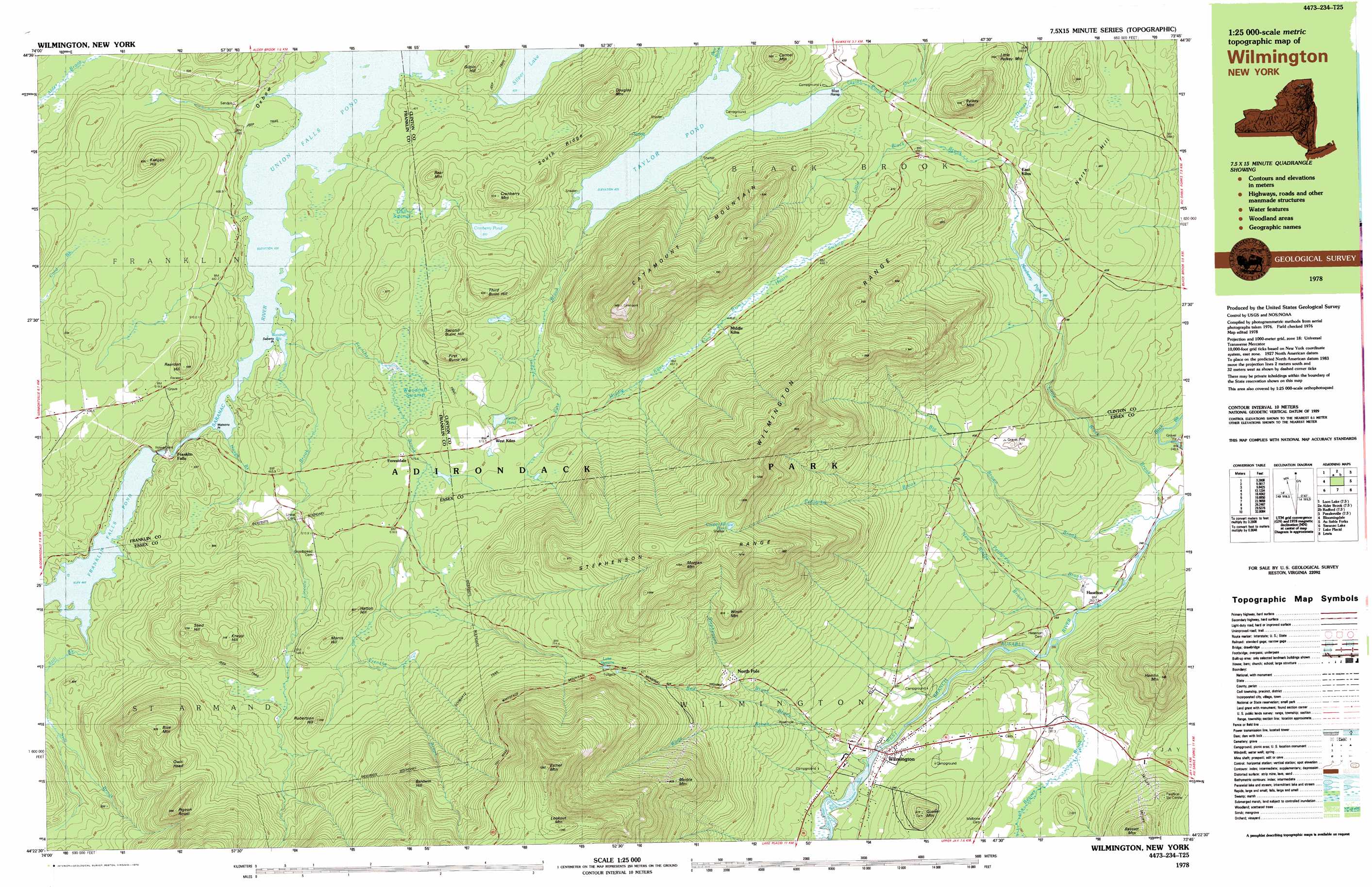
USGS Topo Quad 44073d7 - 1:25,000 scale
| Topo Map Name: | Wilmington |
| USGS Topo Quad ID: | 44073d7 |
| Print Size: | ca. 39" wide x 24" high |
| Southeast Coordinates: | 44.375° N latitude / 73.75° W longitude |
| Map Center Coordinates: | 44.4375° N latitude / 73.875° W longitude |
| U.S. State: | NY |
| Filename: | k44073d7.jpg |
| Download Map JPG Image: | Wilmington topo map 1:25,000 scale |
| Map Type: | Topographic |
| Topo Series: | 7.5´x15´ |
| Map Scale: | 1:25,000 |
| Source of Map Images: | United States Geological Survey (USGS) |
| Alternate Map Versions: |
Wilmington NY 1978, updated 1979 Download PDF Buy paper map |
1:24,000 Topo Quads surrounding Wilmington
Ragged Lake |
Lyon Mountain |
Moffitsville |
Dannemora |
Morrisonville |
Loon Lake |
Alder Brook |
Redford |
Peasleeville |
Peru |
Bloomingdale |
Wilmington |
Clintonville |
||
Mckenzie Mountain |
Keene |
Lewis |
||
Street Mountain |
Keene Valley |
Elizabethtown |
> Back to 44073a1 at 1:100,000 scale
> Back to 44072a1 at 1:250,000 scale
> Back to U.S. Topo Maps home
Wilmington topo map: Gazetteer
Wilmington: Bays
Woodruff Bay elevation 430m 1410′Wilmington: Capes
Seberts Point elevation 431m 1414′Watsons Point elevation 431m 1414′
Wilmington: Lakes
Cooper Kill Pond elevation 916m 3005′Cranberry Pond elevation 513m 1683′
Lake Stevens elevation 708m 2322′
Newberry Pond elevation 382m 1253′
Oncio Pond elevation 498m 1633′
Wilmington: Populated Places
East Kilns elevation 394m 1292′Forestdale elevation 511m 1676′
Franklin Falls elevation 438m 1437′
Haselton elevation 250m 820′
North Pole elevation 522m 1712′
West Kilns elevation 518m 1699′
Wilmington elevation 309m 1013′
Wilmington: Ranges
Stephenson Range elevation 1001m 3284′Wilmington Range elevation 700m 2296′
Wilmington: Reservoirs
Franklin Falls Pond elevation 444m 1456′Taylor Pond elevation 424m 1391′
Union Falls Pond elevation 430m 1410′
Wilmington: Ridges
South Ridge elevation 551m 1807′Wilmington: Streams
Bear Brook elevation 425m 1394′Beaver Brook elevation 251m 823′
Big Brown Brook elevation 241m 790′
Frenchs Brook elevation 431m 1414′
Hough Brook elevation 431m 1414′
Lincoln Brook elevation 433m 1420′
Little Black Brook elevation 241m 790′
Middle Kilns Brook elevation 443m 1453′
New Bridge Brook elevation 251m 823′
Pete Lagus Brook elevation 425m 1394′
Pettigrew Brook elevation 241m 790′
Red Brook elevation 363m 1190′
Stephenson Brook elevation 300m 984′
Still Brook elevation 448m 1469′
White Brook elevation 329m 1079′
Wilmington: Summits
Baldwin Hill elevation 984m 3228′Bear Mountain elevation 572m 1876′
Blue Mountain elevation 805m 2641′
Carmel Mountain elevation 563m 1847′
Catamount Mountain elevation 967m 3172′
Cranberry Mountain elevation 616m 2020′
Douglas Mountain elevation 648m 2125′
Esther Mountain elevation 1293m 4242′
First Burnt Hill elevation 584m 1916′
Gilpin Hill elevation 507m 1663′
Hamlin Mountain elevation 644m 2112′
Hatton Hill elevation 601m 1971′
Keegan Hill elevation 614m 2014′
Knapp Hill elevation 711m 2332′
Little Pelkey Mountain elevation 502m 1646′
Lookout Mountain elevation 1242m 4074′
Marble Mountain elevation 833m 2732′
Morgan Mountain elevation 1050m 3444′
Morris Hill elevation 612m 2007′
North Hill elevation 461m 1512′
Owls Head elevation 793m 2601′
Pelkey Mountan elevation 604m 1981′
Pigeon Roost elevation 840m 2755′
Quaker Mountain elevation 471m 1545′
Reardon Hill elevation 586m 1922′
Robertson Hill elevation 663m 2175′
Second Burnt Hill elevation 593m 1945′
Shed Hill elevation 703m 2306′
Third Burnt Hill elevation 625m 2050′
Winch Mountain elevation 816m 2677′
Wilmington: Swamps
Gail Swamp elevation 488m 1601′Hearn Swamp elevation 444m 1456′
Woodruff Swamp elevation 496m 1627′
Wilmington: Trails
Schwartz Trail elevation 716m 2349′Wilmington digital topo map on disk
Buy this Wilmington topo map showing relief, roads, GPS coordinates and other geographical features, as a high-resolution digital map file on DVD:
New York, Vermont, Connecticut & Western Massachusetts
Buy digital topo maps: New York, Vermont, Connecticut & Western Massachusetts