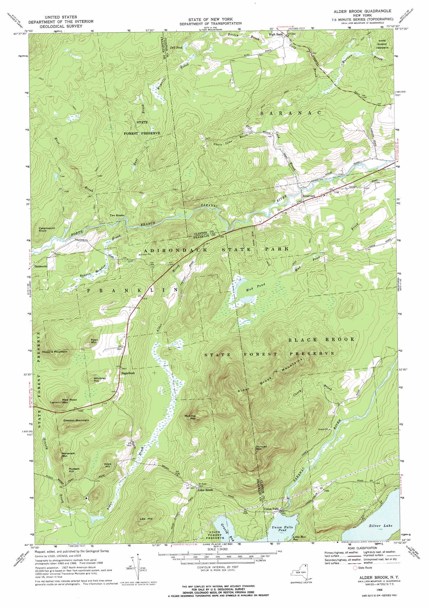
Alder Brook Topo Map New York
To zoom in, hover over the map of Alder Brook
USGS Topo Quad 44073e8 - 1:24,000 scale
| Topo Map Name: | Alder Brook |
| USGS Topo Quad ID: | 44073e8 |
| Print Size: | ca. 21 1/4" wide x 27" high |
| Southeast Coordinates: | 44.5° N latitude / 73.875° W longitude |
| Map Center Coordinates: | 44.5625° N latitude / 73.9375° W longitude |
| U.S. State: | NY |
| Filename: | o44073e8.jpg |
| Download Map JPG Image: | Alder Brook topo map 1:24,000 scale |
| Map Type: | Topographic |
| Topo Series: | 7.5´ |
| Map Scale: | 1:24,000 |
| Source of Map Images: | United States Geological Survey (USGS) |
| Alternate Map Versions: |
Alder Brook NY 1968, updated 1970 Download PDF Buy paper map Alder Brook NY 2010 Download PDF Buy paper map Alder Brook NY 2013 Download PDF Buy paper map Alder Brook NY 2016 Download PDF Buy paper map |
1:24,000 Topo Quads surrounding Alder Brook
Chasm Falls |
Brainardsville |
Ellenburg Center |
Ellenburg Mountain |
Jericho |
Owls Head |
Ragged Lake |
Lyon Mountain |
Moffitsville |
Dannemora |
Debar Mountain |
Loon Lake |
Alder Brook |
Redford |
Peasleeville |
Bloomingdale |
Wilmington |
|||
Mckenzie Mountain |
Keene |
> Back to 44073e1 at 1:100,000 scale
> Back to 44072a1 at 1:250,000 scale
> Back to U.S. Topo Maps home
Alder Brook topo map: Gazetteer
Alder Brook: Airports
High Banks Farm Landing Area elevation 455m 1492′Alder Brook: Bays
Grassy Bay elevation 430m 1410′Little Bear Bay elevation 430m 1410′
Alder Brook: Lakes
Dell Pond elevation 464m 1522′Mud Pond elevation 415m 1361′
Silver Lake elevation 425m 1394′
Alder Brook: Populated Places
Alder Brook elevation 489m 1604′Goldsmith elevation 400m 1312′
Riverview elevation 358m 1174′
Sugarbush elevation 491m 1610′
Two Brooks elevation 389m 1276′
Union Falls elevation 431m 1414′
Alder Brook: Reservoirs
Union Falls Pond elevation 428m 1404′Alder Brook: Ridges
Alder Brook Mountains elevation 683m 2240′Alder Brook: Streams
Alder Brook elevation 353m 1158′Bailey Brook elevation 439m 1440′
Beaver Meadow Brook elevation 365m 1197′
Bernau Brook elevation 394m 1292′
Brandy Brook elevation 418m 1371′
Casey Brook elevation 408m 1338′
Cold Brook elevation 391m 1282′
Cold Brook elevation 343m 1125′
East Brook elevation 372m 1220′
Mud Pond Brook elevation 342m 1122′
Uncle Toms Brook elevation 382m 1253′
Wemette Brook elevation 444m 1456′
West Brook elevation 372m 1220′
Alder Brook: Summits
Catamount Knoll elevation 477m 1564′Duncan Mountain elevation 825m 2706′
Gleason Mountain elevation 593m 1945′
Howard Mountain elevation 610m 2001′
Kees Hill elevation 506m 1660′
Law Hill elevation 601m 1971′
McKillip Mountain elevation 609m 1998′
New Road Mountain elevation 612m 2007′
Noranale Mountain elevation 559m 1833′
Russell Hill elevation 531m 1742′
Ryan Mountain elevation 580m 1902′
Whooley Hill elevation 556m 1824′
Alder Brook digital topo map on disk
Buy this Alder Brook topo map showing relief, roads, GPS coordinates and other geographical features, as a high-resolution digital map file on DVD:
New York, Vermont, Connecticut & Western Massachusetts
Buy digital topo maps: New York, Vermont, Connecticut & Western Massachusetts