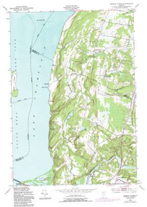
Georgia Plains Topo Map Vermont
To zoom in, hover over the map of Georgia Plains
USGS Topo Quad 44073f2 - 1:24,000 scale
| Topo Map Name: | Georgia Plains |
| USGS Topo Quad ID: | 44073f2 |
| Print Size: | ca. 21 1/4" wide x 27" high |
| Southeast Coordinates: | 44.625° N latitude / 73.125° W longitude |
| Map Center Coordinates: | 44.6875° N latitude / 73.1875° W longitude |
| U.S. State: | VT |
| Filename: | o44073f2.jpg |
| Download Map JPG Image: | Georgia Plains topo map 1:24,000 scale |
| Map Type: | Topographic |
| Topo Series: | 7.5´ |
| Map Scale: | 1:24,000 |
| Source of Map Images: | United States Geological Survey (USGS) |
| Alternate Map Versions: |
Georgia Plains VT 1948, updated 1953 Download PDF Buy paper map Georgia Plains VT 1948, updated 1972 Download PDF Buy paper map Georgia Plains VT 1948, updated 1973 Download PDF Buy paper map Georgia Plains VT 1948, updated 1977 Download PDF Buy paper map Georgia Plains VT 1948, updated 1987 Download PDF Buy paper map Georgia Plains VT 2012 Download PDF Buy paper map Georgia Plains VT 2015 Download PDF Buy paper map |
1:24,000 Topo Quads surrounding Georgia Plains
> Back to 44073e1 at 1:100,000 scale
> Back to 44072a1 at 1:250,000 scale
> Back to U.S. Topo Maps home
Georgia Plains topo map: Gazetteer
Georgia Plains: Airports
Savage Island Airport elevation 41m 134′Savage Island Airport elevation 41m 134′
Shaw Meadow Airport elevation 64m 209′
Georgia Plains: Capes
Beans Point elevation 31m 101′Georgia Plains: Dams
Peterson Dam elevation 30m 98′Georgia Plains: Islands
Savage Island elevation 40m 131′Georgia Plains: Lakes
Long Pond elevation 86m 282′Round Pond elevation 113m 370′
Georgia Plains: Parks
Sand Bar State Park elevation 30m 98′Georgia Plains: Populated Places
Checkerberry Village elevation 100m 328′Georgia Plains elevation 80m 262′
Miltonboro elevation 41m 134′
West Georgia elevation 93m 305′
West Milton elevation 30m 98′
West View elevation 100m 328′
Georgia Plains: Streams
Stone Bridge Brook elevation 29m 95′Streeter Brook elevation 36m 118′
Trout Brook elevation 29m 95′
Georgia Plains: Summits
Bradley Hill elevation 124m 406′Diamond Hill elevation 160m 524′
Eagle Mountain elevation 168m 551′
Fox Hill elevation 114m 374′
Georgia Plains digital topo map on disk
Buy this Georgia Plains topo map showing relief, roads, GPS coordinates and other geographical features, as a high-resolution digital map file on DVD:
New York, Vermont, Connecticut & Western Massachusetts
Buy digital topo maps: New York, Vermont, Connecticut & Western Massachusetts


