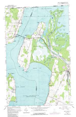
East Alburg Topo Map Vermont
To zoom in, hover over the map of East Alburg
USGS Topo Quad 44073h2 - 1:24,000 scale
| Topo Map Name: | East Alburg |
| USGS Topo Quad ID: | 44073h2 |
| Print Size: | ca. 21 1/4" wide x 27" high |
| Southeast Coordinates: | 44.875° N latitude / 73.125° W longitude |
| Map Center Coordinates: | 44.9375° N latitude / 73.1875° W longitude |
| U.S. State: | VT |
| Filename: | o44073h2.jpg |
| Download Map JPG Image: | East Alburg topo map 1:24,000 scale |
| Map Type: | Topographic |
| Topo Series: | 7.5´ |
| Map Scale: | 1:24,000 |
| Source of Map Images: | United States Geological Survey (USGS) |
| Alternate Map Versions: |
East Alburg VT 1964, updated 1965 Download PDF Buy paper map East Alburg VT 1964, updated 1976 Download PDF Buy paper map East Alburg VT 1964, updated 1987 Download PDF Buy paper map East Alburg VT 2012 Download PDF Buy paper map East Alburg VT 2015 Download PDF Buy paper map |
1:24,000 Topo Quads surrounding East Alburg
Champlain |
Rouses Point |
East Alburg |
Highgate Center |
Sheldon Springs |
Beekmantown |
North Hero |
Saint Albans Bay |
Saint Albans |
Fairfield |
Plattsburgh |
South Hero |
Georgia Plains |
Milton |
Gilson Mountain |
> Back to 44073e1 at 1:100,000 scale
> Back to 44072a1 at 1:250,000 scale
> Back to U.S. Topo Maps home
East Alburg topo map: Gazetteer
East Alburg: Bays
Allens Bay elevation 29m 95′Gander Bay elevation 29m 95′
Goose Bay elevation 29m 95′
Long Marsh Bay elevation 29m 95′
Maquam Bay elevation 29m 95′
East Alburg: Bridges
Missisquoi Bay Bridge elevation 29m 95′Swanton Covered Bridge elevation 30m 98′
East Alburg: Capes
Bull Rush Point elevation 29m 95′Clark Point elevation 33m 108′
Donaldson Point elevation 31m 101′
Hog Island Point elevation 32m 104′
Holiday Point elevation 29m 95′
Martindale Point elevation 29m 95′
McGregor Point elevation 30m 98′
Sandy Point elevation 30m 98′
Stephenson Point elevation 29m 95′
Stony Point elevation 30m 98′
East Alburg: Channels
Long Marsh Channel elevation 29m 95′East Alburg: Dams
Swanton Dam elevation 30m 98′East Alburg: Guts
Big Marsh Slough elevation 29m 95′East Alburg: Islands
Hog Island elevation 33m 108′Mudgett Island elevation 30m 98′
Noaks Island elevation 29m 95′
East Alburg: Parks
Maquam Bay Wildlife Management Area elevation 29m 95′Missisquoi National Wildlife Refuge elevation 30m 98′
North Hero State Park elevation 31m 101′
East Alburg: Populated Places
Alburg Springs elevation 39m 127′Alburg Travel Trailer Park elevation 33m 108′
Camp Maquam elevation 38m 124′
East Alburg elevation 33m 108′
Maquam elevation 34m 111′
West Swanton elevation 33m 108′
East Alburg: Ridges
Black Duck Ridge elevation 30m 98′East Alburg: Streams
Black Creek elevation 29m 95′Brush Creek elevation 30m 98′
Charcoal Creek elevation 29m 95′
Cranberry Creek elevation 29m 95′
Cripple Brush Creek elevation 29m 95′
Dead Creek elevation 29m 95′
First Creek elevation 29m 95′
Maquam Creek elevation 30m 98′
Missisquoi River elevation 29m 95′
Wood Duck Creek elevation 29m 95′
East Alburg digital topo map on disk
Buy this East Alburg topo map showing relief, roads, GPS coordinates and other geographical features, as a high-resolution digital map file on DVD:
New York, Vermont, Connecticut & Western Massachusetts
Buy digital topo maps: New York, Vermont, Connecticut & Western Massachusetts


