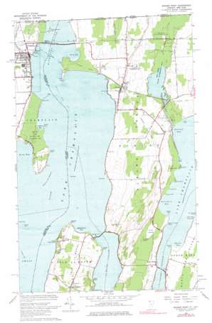
Rouses Point Topo Map Vermont
To zoom in, hover over the map of Rouses Point
USGS Topo Quad 44073h3 - 1:24,000 scale
| Topo Map Name: | Rouses Point |
| USGS Topo Quad ID: | 44073h3 |
| Print Size: | ca. 21 1/4" wide x 27" high |
| Southeast Coordinates: | 44.875° N latitude / 73.25° W longitude |
| Map Center Coordinates: | 44.9375° N latitude / 73.3125° W longitude |
| U.S. States: | VT, NY |
| Filename: | o44073h3.jpg |
| Download Map JPG Image: | Rouses Point topo map 1:24,000 scale |
| Map Type: | Topographic |
| Topo Series: | 7.5´ |
| Map Scale: | 1:24,000 |
| Source of Map Images: | United States Geological Survey (USGS) |
| Alternate Map Versions: |
Rouses Point NY 1966, updated 1968 Download PDF Buy paper map Rouses Point NY 2011 Download PDF Buy paper map Rouses Point NY 2013 Download PDF Buy paper map Rouses Point NY 2016 Download PDF Buy paper map |
1:24,000 Topo Quads surrounding Rouses Point
Mooers |
Champlain |
Rouses Point |
East Alburg |
Highgate Center |
West Chazy |
Beekmantown |
North Hero |
Saint Albans Bay |
Saint Albans |
Morrisonville |
Plattsburgh |
South Hero |
Georgia Plains |
Milton |
> Back to 44073e1 at 1:100,000 scale
> Back to 44072a1 at 1:250,000 scale
> Back to U.S. Topo Maps home
Rouses Point topo map: Gazetteer
Rouses Point: Airports
Rouses Point Seaplane Base elevation 29m 95′Rouses Point: Bars
Ferryall Reef elevation 29m 95′Motte Reef elevation 29m 95′
Point au Fer Reef elevation 29m 95′
Thompson Reef elevation 29m 95′
Windmill Point Reef elevation 29m 95′
Rouses Point: Bays
Blanchard Bay elevation 29m 95′Catfish Bay elevation 29m 95′
Dillenbeck Bay elevation 29m 95′
Kelly Bay elevation 29m 95′
King Bay elevation 29m 95′
Ransoms Bay elevation 29m 95′
Squires Bay elevation 29m 95′
Rouses Point: Bridges
North Hero Bridge elevation 29m 95′Rouses Point Bridge elevation 29m 95′
Rouses Point Bridge elevation 29m 95′
Rouses Point: Capes
Alburg Tongue elevation 52m 170′Balm of Gilead Point elevation 29m 95′
Burying Yard Point elevation 30m 98′
Catfish Point elevation 29m 95′
Cooper Point elevation 29m 95′
Cranska Point elevation 34m 111′
Fee Fee Point elevation 29m 95′
Goose Point elevation 29m 95′
Long Point elevation 29m 95′
Long Point elevation 29m 95′
Mud Point elevation 29m 95′
Point Au Fer elevation 34m 111′
Reed Point elevation 30m 98′
Reynolds Point elevation 31m 101′
Sandy Point elevation 30m 98′
Scales Point elevation 30m 98′
Stony Point elevation 29m 95′
Wagner Point elevation 31m 101′
Windmill Point elevation 31m 101′
Rouses Point: Channels
Alburg Passage elevation 29m 95′La Motte Passage elevation 29m 95′
Point au Fer Channel elevation 29m 95′
Rouses Point: Cliffs
Big Bluff elevation 29m 95′Little Bluff elevation 35m 114′
Rouses Point: Dams
Mud Creek Dam elevation 30m 98′Rouses Point: Islands
Hemlock Island elevation 30m 98′Pine Island elevation 34m 111′
Rouses Point: Lakes
Devils Pond elevation 29m 95′Eagle Pond elevation 29m 95′
Rouses Point: Parks
Fort Saint Anne Monument elevation 45m 147′Isle La Motte Monument elevation 30m 98′
King Bay State Wetland Game Management Area elevation 30m 98′
Mud Creek State Waterfowl Area elevation 30m 98′
Samuel de Champlain Statue elevation 45m 147′
Rouses Point: Pillars
Blue Rock elevation 30m 98′Rouses Point: Populated Places
Alburg elevation 38m 124′Alburg Center elevation 37m 121′
Isle la Motte elevation 56m 183′
Rouses Point elevation 34m 111′
South Alburg elevation 34m 111′
Rouses Point: Post Offices
Alburgh Post Office elevation 36m 118′Isle La Motte Post Office elevation 44m 144′
Rouses Point: Reservoirs
Mud Creek Pond elevation 30m 98′Rouses Point: Streams
Mud Creek elevation 29m 95′Sucker Brook elevation 30m 98′
Rouses Point: Summits
Stanhope Hill elevation 51m 167′Rouses Point digital topo map on disk
Buy this Rouses Point topo map showing relief, roads, GPS coordinates and other geographical features, as a high-resolution digital map file on DVD:
New York, Vermont, Connecticut & Western Massachusetts
Buy digital topo maps: New York, Vermont, Connecticut & Western Massachusetts


