Slim Pond Topo Map New York
To zoom in, hover over the map of Slim Pond
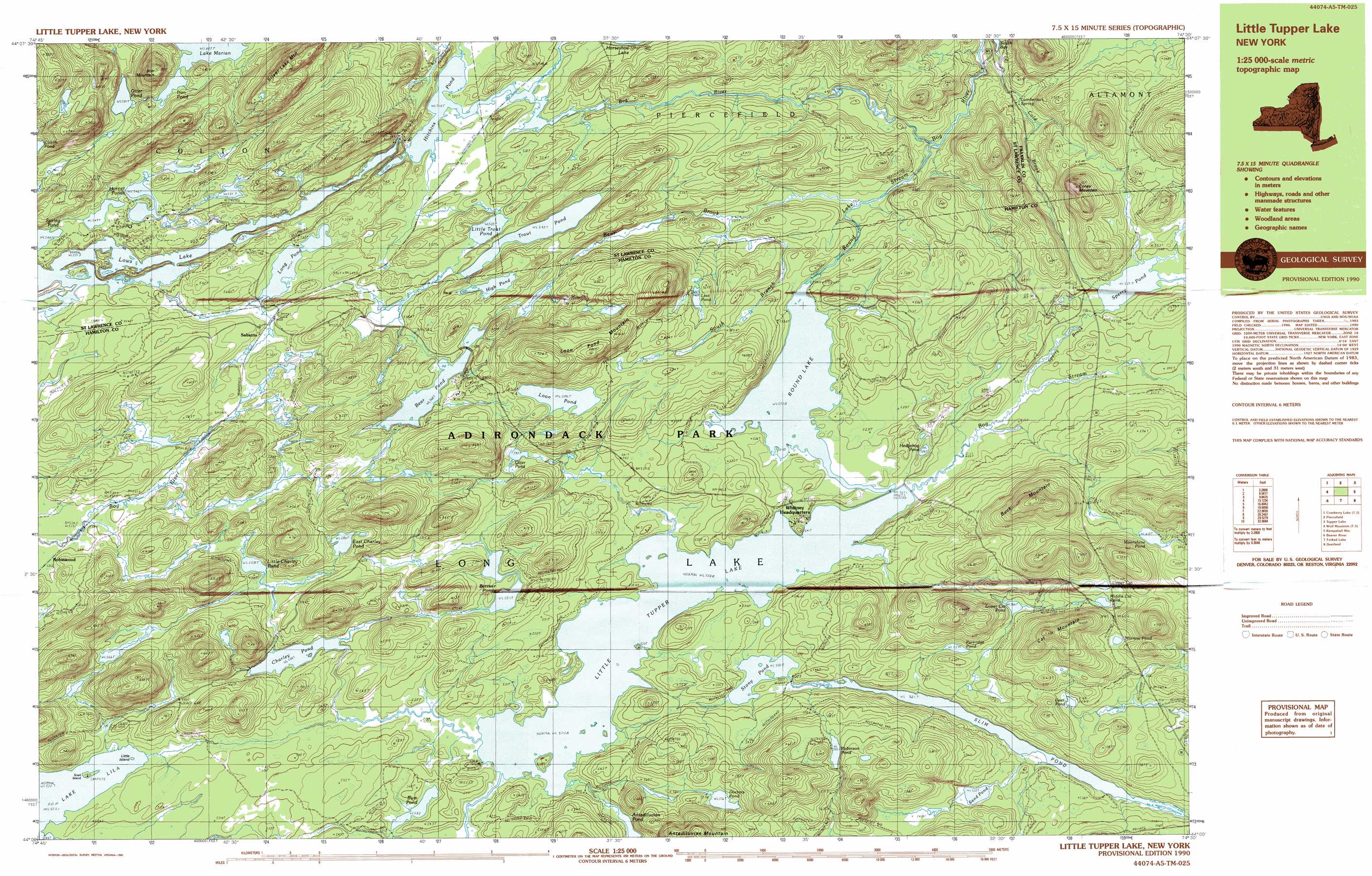
USGS Topo Quad 44074a5 - 1:25,000 scale
| Topo Map Name: | Slim Pond |
| USGS Topo Quad ID: | 44074a5 |
| Print Size: | ca. 39" wide x 24" high |
| Southeast Coordinates: | 44° N latitude / 74.5° W longitude |
| Map Center Coordinates: | 44.0625° N latitude / 74.625° W longitude |
| U.S. State: | NY |
| Filename: | k44074a5.jpg |
| Download Map JPG Image: | Slim Pond topo map 1:25,000 scale |
| Map Type: | Topographic |
| Topo Series: | 7.5´x15´ |
| Map Scale: | 1:25,000 |
| Source of Map Images: | United States Geological Survey (USGS) |
| Alternate Map Versions: |
Little Tupper Lake NY 1990, updated 1990 Download PDF Buy paper map Little Tupper Lake NY 1999, updated 2001 Download PDF Buy paper map |
1:24,000 Topo Quads surrounding Slim Pond
Brother Ponds |
Childwold |
Mount Matumbla |
Upper Saranac Lake |
|
Cranberry Lake |
Pierce Field |
Stony Creek Mountain |
||
Wolf Mountain |
Slim Pond |
Kempshall Mountain |
||
Nehasane Lake |
Forked Lake |
Dunbrook Mountain |
||
Eagle Bay |
Sargent Ponds |
Burgess Mountain |
> Back to 44074a1 at 1:100,000 scale
> Back to 44074a1 at 1:250,000 scale
> Back to U.S. Topo Maps home
Slim Pond topo map: Gazetteer
Slim Pond: Lakes
Antediluvian Pond elevation 533m 1748′Bear Pond elevation 568m 1863′
Bettner Ponds elevation 551m 1807′
Bum Pond elevation 531m 1742′
Charley Pond elevation 538m 1765′
Deer Pond elevation 563m 1847′
Doctors Pond elevation 556m 1824′
East Charley Pond elevation 581m 1906′
Hedgehog Pond elevation 528m 1732′
High Pond elevation 574m 1883′
Hitchins Pond elevation 522m 1712′
Hornet Ponds elevation 546m 1791′
Iron Pond elevation 607m 1991′
Lake Marian elevation 607m 1991′
Little Charley Pond elevation 558m 1830′
Little Trout Pond elevation 535m 1755′
Little Tupper Lake elevation 524m 1719′
Long Pond elevation 545m 1788′
Loon Pond elevation 586m 1922′
Lost Pond elevation 560m 1837′
Lower Cat Pond elevation 566m 1856′
Middle Cat Pond elevation 598m 1961′
Minnow Pond elevation 592m 1942′
Moonshine Pond elevation 610m 2001′
Otter Pond elevation 581m 1906′
Otter Pond elevation 546m 1791′
Partridge Pond elevation 557m 1827′
Robinson Pond elevation 590m 1935′
Round Lake elevation 524m 1719′
Sand Pond elevation 533m 1748′
Spring Pond elevation 548m 1797′
Stony Pond elevation 522m 1712′
Trout Pond elevation 545m 1788′
Upper Cat Pond elevation 604m 1981′
Slim Pond: Populated Places
Robinwood elevation 537m 1761′Sabattis elevation 552m 1811′
Slim Pond: Reservoirs
Lows Lake elevation 537m 1761′Slim Pond elevation 522m 1712′
Sperry Pond elevation 541m 1774′
Slim Pond: Streams
Bear Brook elevation 497m 1630′Bog River elevation 480m 1574′
Bog Stream elevation 524m 1719′
Cold Brook elevation 473m 1551′
Round Lake Outlet elevation 535m 1755′
South Branch Bear Brook elevation 507m 1663′
Sperry Brook elevation 528m 1732′
Slim Pond: Summits
Buck Mountain elevation 729m 2391′Cat Mountain elevation 668m 2191′
Coney Mountain elevation 691m 2267′
Goodman Mountain elevation 659m 2162′
Iron Mountain elevation 736m 2414′
Loon Pond Mountain elevation 702m 2303′
Silver Lake Mountain elevation 771m 2529′
Slim Pond digital topo map on disk
Buy this Slim Pond topo map showing relief, roads, GPS coordinates and other geographical features, as a high-resolution digital map file on DVD:
New York, Vermont, Connecticut & Western Massachusetts
Buy digital topo maps: New York, Vermont, Connecticut & Western Massachusetts