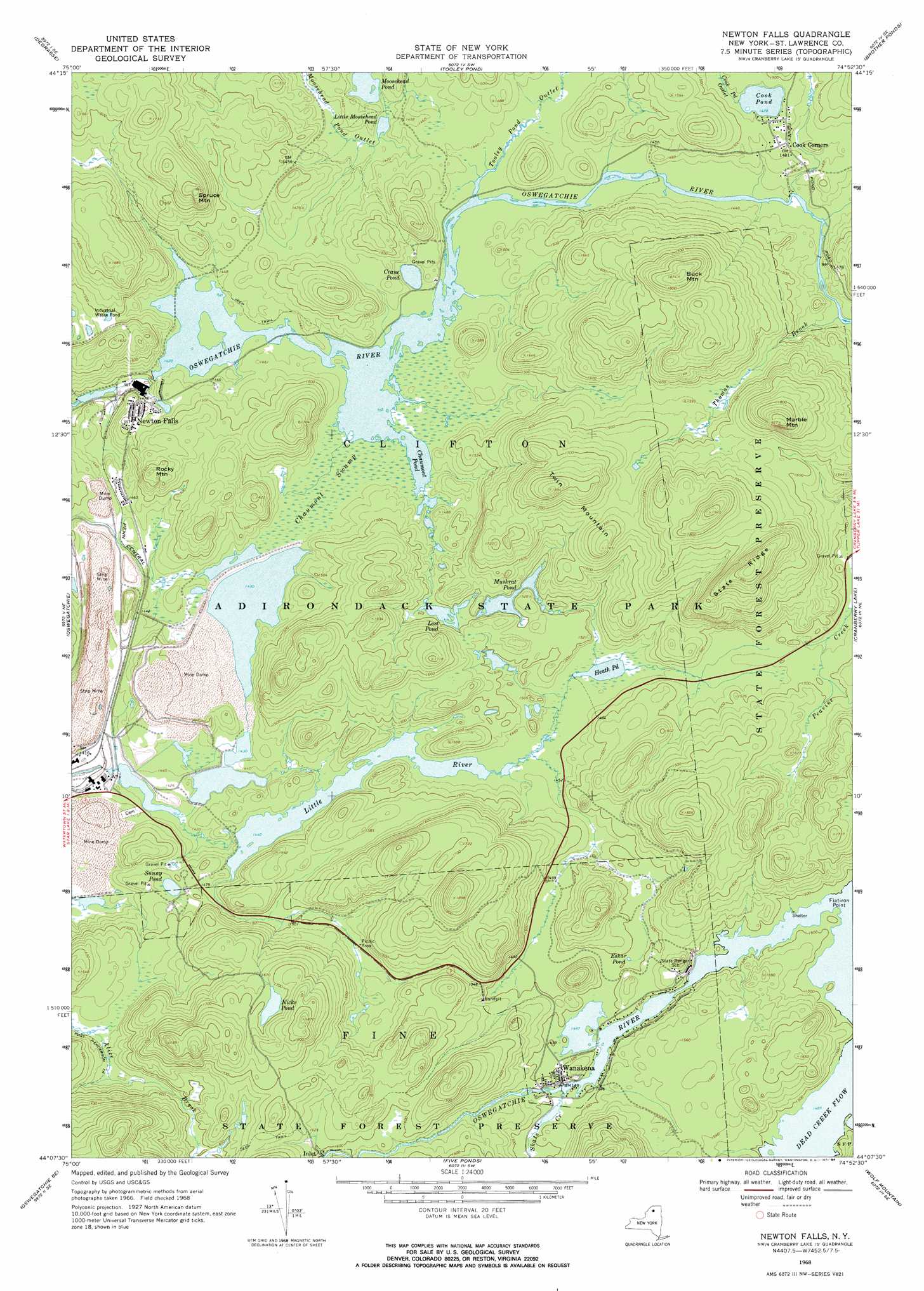
Newton Falls Topo Map New York
To zoom in, hover over the map of Newton Falls
USGS Topo Quad 44074b8 - 1:24,000 scale
| Topo Map Name: | Newton Falls |
| USGS Topo Quad ID: | 44074b8 |
| Print Size: | ca. 21 1/4" wide x 27" high |
| Southeast Coordinates: | 44.125° N latitude / 74.875° W longitude |
| Map Center Coordinates: | 44.1875° N latitude / 74.9375° W longitude |
| U.S. State: | NY |
| Filename: | o44074b8.jpg |
| Download Map JPG Image: | Newton Falls topo map 1:24,000 scale |
| Map Type: | Topographic |
| Topo Series: | 7.5´ |
| Map Scale: | 1:24,000 |
| Source of Map Images: | United States Geological Survey (USGS) |
| Alternate Map Versions: |
Newton Falls NY 1968, updated 1971 Download PDF Buy paper map Newton Falls NY 1968, updated 1984 Download PDF Buy paper map Newton Falls NY 1999, updated 2001 Download PDF Buy paper map Newton Falls NY 2010 Download PDF Buy paper map Newton Falls NY 2013 Download PDF Buy paper map Newton Falls NY 2016 Download PDF Buy paper map |
1:24,000 Topo Quads surrounding Newton Falls
Hermon |
West Pierrepont |
Albert Marsh |
Stark |
Carry Falls Reservoir |
South Edwards |
Degrasse |
Tooley Pond |
Brother Ponds |
Childwold |
Fine |
Oswegatchie |
Newton Falls |
Cranberry Lake |
|
Oswegatchie Sw |
Oswegatchie Se |
Five Ponds |
Wolf Mountain |
|
Stillwater Reservoir West |
Nehasane Lake |
> Back to 44074a1 at 1:100,000 scale
> Back to 44074a1 at 1:250,000 scale
> Back to U.S. Topo Maps home
Newton Falls topo map: Gazetteer
Newton Falls: Bays
Dead Creek Flow elevation 452m 1482′Newton Falls: Capes
Flatiron Point elevation 455m 1492′Newton Falls: Lakes
Chaumont Pond elevation 433m 1420′Cook Pond elevation 450m 1476′
Crane Pond elevation 432m 1417′
Eskar Pond elevation 457m 1499′
Heath Pond elevation 441m 1446′
Little Moosehead Pond elevation 430m 1410′
Lost Pond elevation 456m 1496′
Muskrat Pond elevation 454m 1489′
Nicks Pond elevation 513m 1683′
Sunny Pond elevation 449m 1473′
Newton Falls: Populated Places
Cook Corners elevation 451m 1479′Newton Falls elevation 456m 1496′
Wanakena elevation 458m 1502′
Newton Falls: Ridges
State Ridge elevation 588m 1929′Newton Falls: Streams
Skate Creek elevation 454m 1489′Thomas Brook elevation 434m 1423′
Tooley Pond Outlet elevation 433m 1420′
Newton Falls: Summits
Buck Mountain elevation 570m 1870′Marble Mountain elevation 587m 1925′
Rocky Mountain elevation 500m 1640′
Spruce Mountain elevation 538m 1765′
Twin Mountain elevation 574m 1883′
Newton Falls: Swamps
Chaumont Swamp elevation 436m 1430′Newton Falls: Trails
Post Henderson Trail elevation 467m 1532′Newton Falls digital topo map on disk
Buy this Newton Falls topo map showing relief, roads, GPS coordinates and other geographical features, as a high-resolution digital map file on DVD:
New York, Vermont, Connecticut & Western Massachusetts
Buy digital topo maps: New York, Vermont, Connecticut & Western Massachusetts