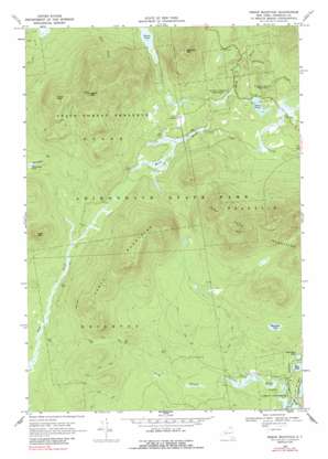
Debar Mountain Topo Map New York
To zoom in, hover over the map of Debar Mountain
USGS Topo Quad 44074e2 - 1:24,000 scale
| Topo Map Name: | Debar Mountain |
| USGS Topo Quad ID: | 44074e2 |
| Print Size: | ca. 21 1/4" wide x 27" high |
| Southeast Coordinates: | 44.5° N latitude / 74.125° W longitude |
| Map Center Coordinates: | 44.5625° N latitude / 74.1875° W longitude |
| U.S. State: | NY |
| Filename: | o44074e2.jpg |
| Download Map JPG Image: | Debar Mountain topo map 1:24,000 scale |
| Map Type: | Topographic |
| Topo Series: | 7.5´ |
| Map Scale: | 1:24,000 |
| Source of Map Images: | United States Geological Survey (USGS) |
| Alternate Map Versions: |
Debar Mountain NY 1968, updated 1970 Download PDF Buy paper map Debar Mountain NY 1968, updated 1988 Download PDF Buy paper map Debar Mountain NY 1968, updated 1988 Download PDF Buy paper map Debar Mountain NY 2010 Download PDF Buy paper map Debar Mountain NY 2013 Download PDF Buy paper map Debar Mountain NY 2016 Download PDF Buy paper map |
1:24,000 Topo Quads surrounding Debar Mountain
> Back to 44074e1 at 1:100,000 scale
> Back to 44074a1 at 1:250,000 scale
> Back to U.S. Topo Maps home
Debar Mountain topo map: Gazetteer
Debar Mountain: Channels
Rainbow Narrows elevation 509m 1669′Debar Mountain: Lakes
Debar Pond elevation 477m 1564′Duck Pond elevation 502m 1646′
Hope Pond elevation 517m 1696′
Little Hope Pond elevation 517m 1696′
Mountain Pond elevation 557m 1827′
Winnebago Pond elevation 504m 1653′
Debar Mountain: Ridges
Loon Lake Mountains elevation 1010m 3313′Sable Mountains elevation 884m 2900′
Debar Mountain: Streams
Plumadore Brook elevation 439m 1440′Debar Mountain: Summits
Baldface Mountain elevation 858m 2814′Black Peak elevation 823m 2700′
Debar Mountain elevation 1011m 3316′
East Mountain elevation 724m 2375′
Debar Mountain digital topo map on disk
Buy this Debar Mountain topo map showing relief, roads, GPS coordinates and other geographical features, as a high-resolution digital map file on DVD:
New York, Vermont, Connecticut & Western Massachusetts
Buy digital topo maps: New York, Vermont, Connecticut & Western Massachusetts


