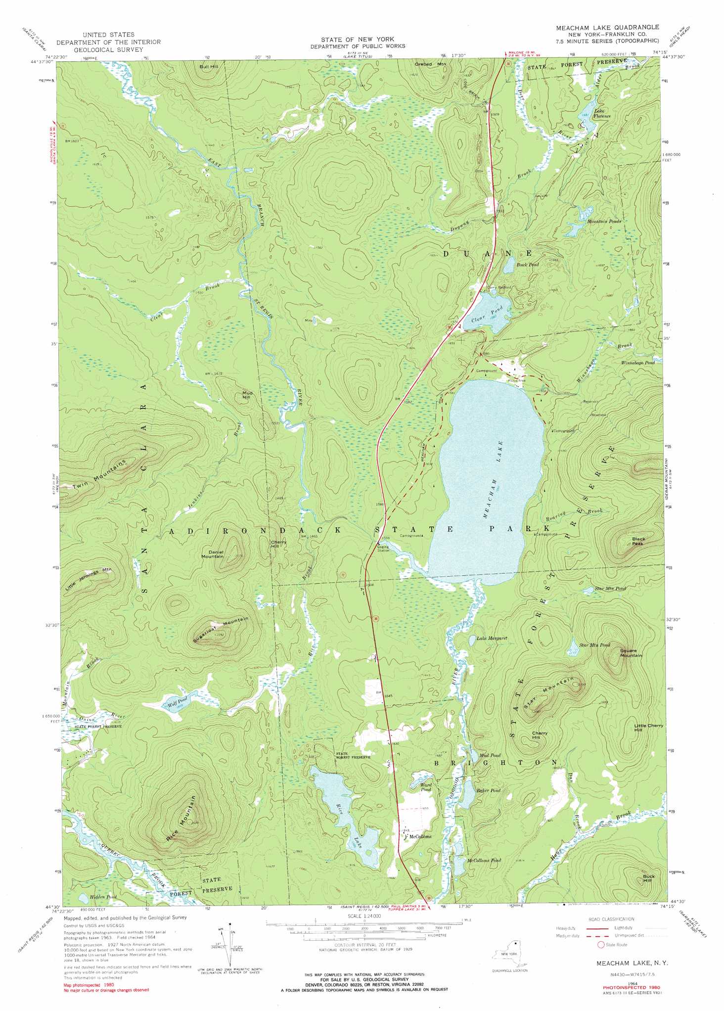
Meacham Lake Topo Map New York
To zoom in, hover over the map of Meacham Lake
USGS Topo Quad 44074e3 - 1:24,000 scale
| Topo Map Name: | Meacham Lake |
| USGS Topo Quad ID: | 44074e3 |
| Print Size: | ca. 21 1/4" wide x 27" high |
| Southeast Coordinates: | 44.5° N latitude / 74.25° W longitude |
| Map Center Coordinates: | 44.5625° N latitude / 74.3125° W longitude |
| U.S. State: | NY |
| Filename: | o44074e3.jpg |
| Download Map JPG Image: | Meacham Lake topo map 1:24,000 scale |
| Map Type: | Topographic |
| Topo Series: | 7.5´ |
| Map Scale: | 1:24,000 |
| Source of Map Images: | United States Geological Survey (USGS) |
| Alternate Map Versions: |
Meacham Lake NY 1964, updated 1966 Download PDF Buy paper map Meacham Lake NY 1964, updated 1976 Download PDF Buy paper map Meacham Lake NY 1964, updated 1984 Download PDF Buy paper map Meacham Lake NY 2010 Download PDF Buy paper map Meacham Lake NY 2013 Download PDF Buy paper map Meacham Lake NY 2016 Download PDF Buy paper map |
1:24,000 Topo Quads surrounding Meacham Lake
Brushton |
Bangor |
Malone |
Chasm Falls |
Brainardsville |
Saint Regis Falls |
Santa Clara |
Lake Titus |
Owls Head |
Ragged Lake |
Lake Ozonia |
Meno |
Meacham Lake |
Debar Mountain |
Loon Lake |
Augerhole Falls |
Saint Regis Mountain |
Bloomingdale |
||
Mount Matumbla |
Upper Saranac Lake |
Mckenzie Mountain |
> Back to 44074e1 at 1:100,000 scale
> Back to 44074a1 at 1:250,000 scale
> Back to U.S. Topo Maps home
Meacham Lake topo map: Gazetteer
Meacham Lake: Lakes
Baker Pond elevation 475m 1558′Buck Pond elevation 466m 1528′
Clear Pond elevation 475m 1558′
Hidden Pond elevation 492m 1614′
Lake Florence elevation 451m 1479′
Lake Margaret elevation 473m 1551′
McColloms Pond elevation 475m 1558′
Meacham Lake elevation 473m 1551′
Mountain Ponds elevation 493m 1617′
Mud Pond elevation 475m 1558′
Rice Lake elevation 483m 1584′
Star Mountain Pond elevation 510m 1673′
Star Mountain Pond elevation 521m 1709′
Ward Pond elevation 485m 1591′
Wolf Pond elevation 490m 1607′
Meacham Lake: Populated Places
McColloms elevation 500m 1640′Meacham Lake: Streams
Alder Brook elevation 454m 1489′Clear Brook elevation 433m 1420′
Dan Brook elevation 487m 1597′
Dugway Brook elevation 445m 1459′
Jenkins Brook elevation 443m 1453′
Mountain Brook elevation 485m 1591′
Osgood River elevation 473m 1551′
Rice Brook elevation 439m 1440′
Roaring Brook elevation 473m 1551′
Winnebago Brook elevation 473m 1551′
Meacham Lake: Summits
Black Peak elevation 670m 2198′Buck Hill elevation 589m 1932′
Bull Hill elevation 589m 1932′
Cherry Hill elevation 586m 1922′
Cherry Hill elevation 561m 1840′
Daniel Mountain elevation 656m 2152′
Little Cherry Hill elevation 561m 1840′
Little Jennings Mountain elevation 684m 2244′
Mud Hill elevation 497m 1630′
Panther Mountain elevation 481m 1578′
Rice Mountain elevation 768m 2519′
Square Mountain elevation 662m 2171′
Star Mountain elevation 647m 2122′
Sugarloaf Mountain elevation 698m 2290′
Twin Mountains elevation 704m 2309′
Meacham Lake digital topo map on disk
Buy this Meacham Lake topo map showing relief, roads, GPS coordinates and other geographical features, as a high-resolution digital map file on DVD:
New York, Vermont, Connecticut & Western Massachusetts
Buy digital topo maps: New York, Vermont, Connecticut & Western Massachusetts