Parishville Topo Map New York
To zoom in, hover over the map of Parishville
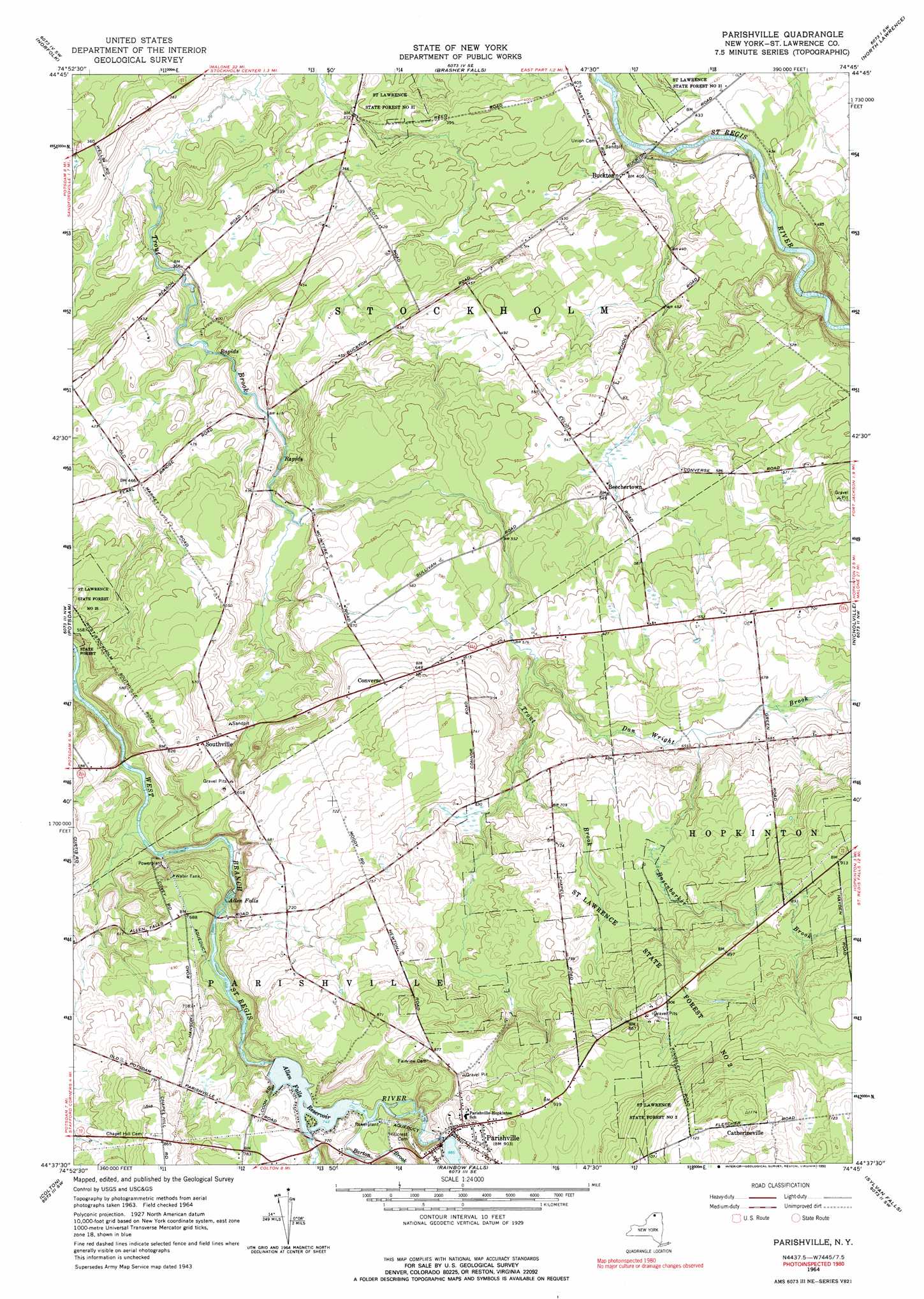
USGS Topo Quad 44074f7 - 1:24,000 scale
| Topo Map Name: | Parishville |
| USGS Topo Quad ID: | 44074f7 |
| Print Size: | ca. 21 1/4" wide x 27" high |
| Southeast Coordinates: | 44.625° N latitude / 74.75° W longitude |
| Map Center Coordinates: | 44.6875° N latitude / 74.8125° W longitude |
| U.S. State: | NY |
| Filename: | o44074f7.jpg |
| Download Map JPG Image: | Parishville topo map 1:24,000 scale |
| Map Type: | Topographic |
| Topo Series: | 7.5´ |
| Map Scale: | 1:24,000 |
| Source of Map Images: | United States Geological Survey (USGS) |
| Alternate Map Versions: |
Parishville NY 1943, updated 1961 Download PDF Buy paper map Parishville NY 1964, updated 1966 Download PDF Buy paper map Parishville NY 1964, updated 1976 Download PDF Buy paper map Parishville NY 1964, updated 1990 Download PDF Buy paper map Parishville NY 2010 Download PDF Buy paper map Parishville NY 2013 Download PDF Buy paper map Parishville NY 2016 Download PDF Buy paper map |
1:24,000 Topo Quads surrounding Parishville
Louisville |
Massena |
Raquette River |
Hogansburg |
Bombay |
Chase Mills |
Norfolk |
Brasher Falls |
North Lawrence |
Brushton |
West Potsdam |
Potsdam |
Parishville |
Nicholville |
Saint Regis Falls |
Pierrepont |
Colton |
Rainbow Falls |
Sylvan Falls |
Lake Ozonia |
West Pierrepont |
Albert Marsh |
Stark |
Carry Falls Reservoir |
Augerhole Falls |
> Back to 44074e1 at 1:100,000 scale
> Back to 44074a1 at 1:250,000 scale
> Back to U.S. Topo Maps home
Parishville topo map: Gazetteer
Parishville: Falls
Allen Falls elevation 176m 577′Parishville: Forests
Saint Lawrence State Forest Number 2 elevation 265m 869′Saint Lawrence State Forest Number 31 elevation 113m 370′
Parishville: Populated Places
Beechertown elevation 167m 547′Buckton elevation 120m 393′
Catherineville elevation 352m 1154′
Converse elevation 199m 652′
Parishville elevation 272m 892′
Southville elevation 191m 626′
Parishville: Reservoirs
Allen Falls Reservoir elevation 216m 708′Parishville: Streams
Alder Meadow Brook elevation 226m 741′Barton Brook elevation 226m 741′
Dan Wright Brook elevation 175m 574′
Rosenbarker Brook elevation 197m 646′
Parishville digital topo map on disk
Buy this Parishville topo map showing relief, roads, GPS coordinates and other geographical features, as a high-resolution digital map file on DVD:
New York, Vermont, Connecticut & Western Massachusetts
Buy digital topo maps: New York, Vermont, Connecticut & Western Massachusetts