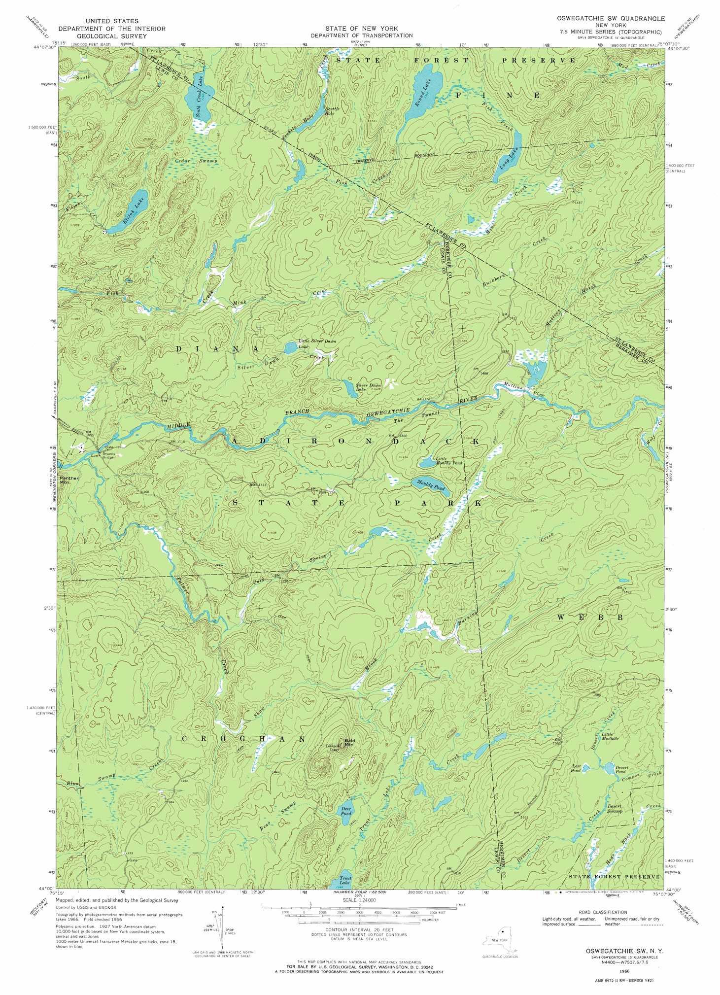
Oswegatchie Sw Topo Map New York
To zoom in, hover over the map of Oswegatchie Sw
USGS Topo Quad 44075a2 - 1:24,000 scale
| Topo Map Name: | Oswegatchie Sw |
| USGS Topo Quad ID: | 44075a2 |
| Print Size: | ca. 21 1/4" wide x 27" high |
| Southeast Coordinates: | 44° N latitude / 75.125° W longitude |
| Map Center Coordinates: | 44.0625° N latitude / 75.1875° W longitude |
| U.S. State: | NY |
| Filename: | o44075a2.jpg |
| Download Map JPG Image: | Oswegatchie Sw topo map 1:24,000 scale |
| Map Type: | Topographic |
| Topo Series: | 7.5´ |
| Map Scale: | 1:24,000 |
| Source of Map Images: | United States Geological Survey (USGS) |
| Alternate Map Versions: |
Oswegatchie SW NY 1966, updated 1971 Download PDF Buy paper map Oswegatchie SW NY 2010 Download PDF Buy paper map Oswegatchie SW NY 2013 Download PDF Buy paper map Oswegatchie SW NY 2016 Download PDF Buy paper map |
1:24,000 Topo Quads surrounding Oswegatchie Sw
Gouverneur |
Edwards |
South Edwards |
Degrasse |
Tooley Pond |
Lake Bonaparte |
Harrisville |
Fine |
Oswegatchie |
Newton Falls |
Natural Bridge |
Remington Corners |
Oswegatchie Sw |
Oswegatchie Se |
Five Ponds |
Croghan |
Belfort |
Stillwater Reservoir West |
||
Lowville |
Crystal Dale |
Stillwater Mountain |
> Back to 44075a1 at 1:100,000 scale
> Back to 44074a1 at 1:250,000 scale
> Back to U.S. Topo Maps home
Oswegatchie Sw topo map: Gazetteer
Oswegatchie Sw: Bridges
Bryants Bridge elevation 305m 1000′Oswegatchie Sw: Channels
Mullins Flow elevation 408m 1338′The Tunnel elevation 396m 1299′
Oswegatchie Sw: Lakes
Deer Pond elevation 417m 1368′Desert Pond elevation 466m 1528′
Elijah Lake elevation 346m 1135′
Little Mouldy Pond elevation 425m 1394′
Little Mudhole elevation 469m 1538′
Little Silver Dawn Lake elevation 381m 1250′
Long Lake elevation 414m 1358′
Lost Pond elevation 467m 1532′
Mouldy Pond elevation 424m 1391′
Round Lake elevation 409m 1341′
Scuttle Hole elevation 363m 1190′
Silver Dawn Lake elevation 423m 1387′
South Greek Lake elevation 347m 1138′
Trout Lake elevation 410m 1345′
Oswegatchie Sw: Streams
Buckhorn Creek elevation 393m 1289′Burning Creek elevation 420m 1377′
Cold Spring Creek elevation 354m 1161′
Cold Spring Creek elevation 302m 990′
Compos Creek elevation 465m 1525′
Mink Creek elevation 330m 1082′
Mullins Marsh Creek elevation 417m 1368′
Palmer Creek elevation 305m 1000′
Scuttle Hole Creek elevation 358m 1174′
Shaw Brook elevation 393m 1289′
Silver Dawn Creek elevation 337m 1105′
Trout Lake Creek elevation 412m 1351′
Oswegatchie Sw: Summits
Bald Mountain elevation 502m 1646′Oswegatchie Sw: Swamps
Bear Swamp elevation 425m 1394′Cedar Swamp elevation 352m 1154′
Desert Swamp elevation 462m 1515′
Oswegatchie Sw digital topo map on disk
Buy this Oswegatchie Sw topo map showing relief, roads, GPS coordinates and other geographical features, as a high-resolution digital map file on DVD:
New York, Vermont, Connecticut & Western Massachusetts
Buy digital topo maps: New York, Vermont, Connecticut & Western Massachusetts