Remington Corners Topo Map New York
To zoom in, hover over the map of Remington Corners
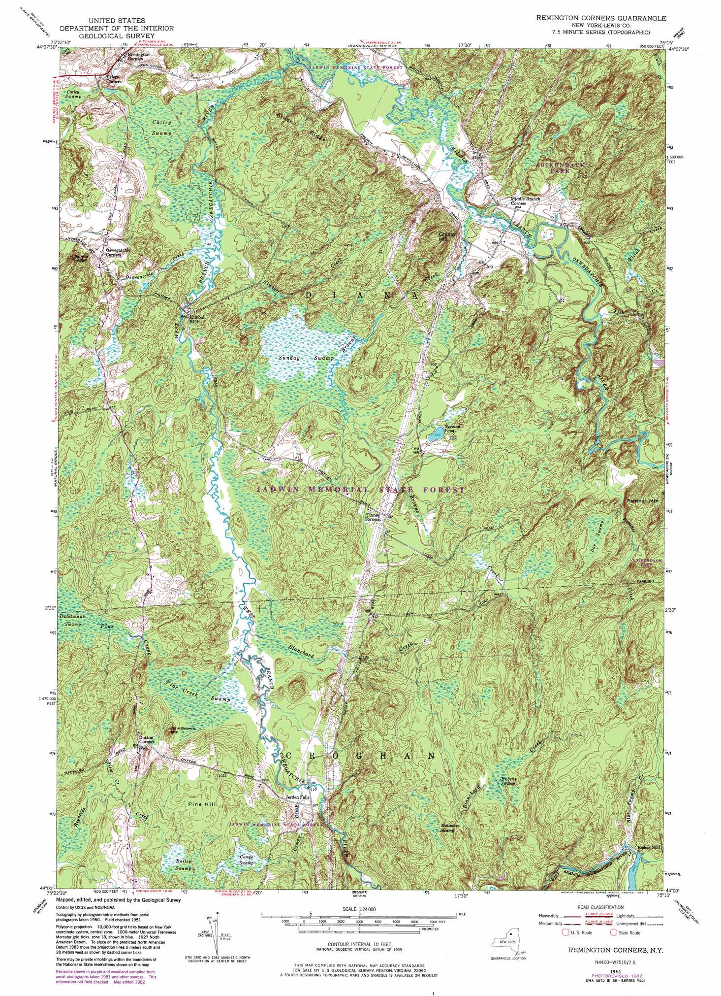
USGS Topo Quad 44075a3 - 1:24,000 scale
| Topo Map Name: | Remington Corners |
| USGS Topo Quad ID: | 44075a3 |
| Print Size: | ca. 21 1/4" wide x 27" high |
| Southeast Coordinates: | 44° N latitude / 75.25° W longitude |
| Map Center Coordinates: | 44.0625° N latitude / 75.3125° W longitude |
| U.S. State: | NY |
| Filename: | o44075a3.jpg |
| Download Map JPG Image: | Remington Corners topo map 1:24,000 scale |
| Map Type: | Topographic |
| Topo Series: | 7.5´ |
| Map Scale: | 1:24,000 |
| Source of Map Images: | United States Geological Survey (USGS) |
| Alternate Map Versions: |
Remington Corners NY 1951, updated 1952 Download PDF Buy paper map Remington Corners NY 1951, updated 1968 Download PDF Buy paper map Remington Corners NY 1951, updated 1983 Download PDF Buy paper map Remington Corners NY 1951, updated 1983 Download PDF Buy paper map Remington Corners NY 2010 Download PDF Buy paper map Remington Corners NY 2013 Download PDF Buy paper map Remington Corners NY 2016 Download PDF Buy paper map |
1:24,000 Topo Quads surrounding Remington Corners
Natural Dam |
Gouverneur |
Edwards |
South Edwards |
Degrasse |
Antwerp |
Lake Bonaparte |
Harrisville |
Fine |
Oswegatchie |
North Wilna |
Natural Bridge |
Remington Corners |
Oswegatchie Sw |
Oswegatchie Se |
Carthage |
Croghan |
Belfort |
Stillwater Reservoir West |
|
West Lowville |
Lowville |
Crystal Dale |
Stillwater Mountain |
> Back to 44075a1 at 1:100,000 scale
> Back to 44074a1 at 1:250,000 scale
> Back to U.S. Topo Maps home
Remington Corners topo map: Gazetteer
Remington Corners: Benches
Palmer Ledge elevation 329m 1079′Remington Corners: Lakes
Norman Pond elevation 289m 948′Remington Corners: Populated Places
Bishas Mill elevation 396m 1299′Jerden Falls elevation 281m 921′
Kimball Mill elevation 270m 885′
Remington Corners elevation 243m 797′
Remington Corners: Ridges
Brushy Ridge elevation 297m 974′Remington Corners: Streams
Blanchard Creek elevation 275m 902′Blue Swamp Creek elevation 389m 1276′
Browns Creek elevation 256m 839′
Compo Creek elevation 277m 908′
Elijah Creek elevation 270m 885′
First Creek elevation 274m 898′
Fish Creek elevation 256m 839′
Kimball Creek elevation 256m 839′
Middle Branch Oswegatchie River elevation 254m 833′
Oswegatchie Creek elevation 256m 839′
Panther Creek elevation 293m 961′
Pine Creek elevation 274m 898′
Tims Creek elevation 267m 875′
Remington Corners: Summits
Grassy Hill elevation 347m 1138′John Browns Mountain elevation 315m 1033′
Panther Mountain elevation 371m 1217′
Pine Hill elevation 314m 1030′
Remington Corners: Swamps
Bailey Swamp elevation 301m 987′Bobcat Swamp elevation 358m 1174′
Carley Swamp elevation 258m 846′
Carley Swamp elevation 258m 846′
Compo Swamp elevation 303m 994′
Doe Swamp elevation 315m 1033′
Dutchmans Swamp elevation 283m 928′
Mountain Swamp elevation 343m 1125′
Pine Creek Swamp elevation 279m 915′
Sunday Swamp elevation 275m 902′
Remington Corners digital topo map on disk
Buy this Remington Corners topo map showing relief, roads, GPS coordinates and other geographical features, as a high-resolution digital map file on DVD:
New York, Vermont, Connecticut & Western Massachusetts
Buy digital topo maps: New York, Vermont, Connecticut & Western Massachusetts