Black River Topo Map New York
To zoom in, hover over the map of Black River
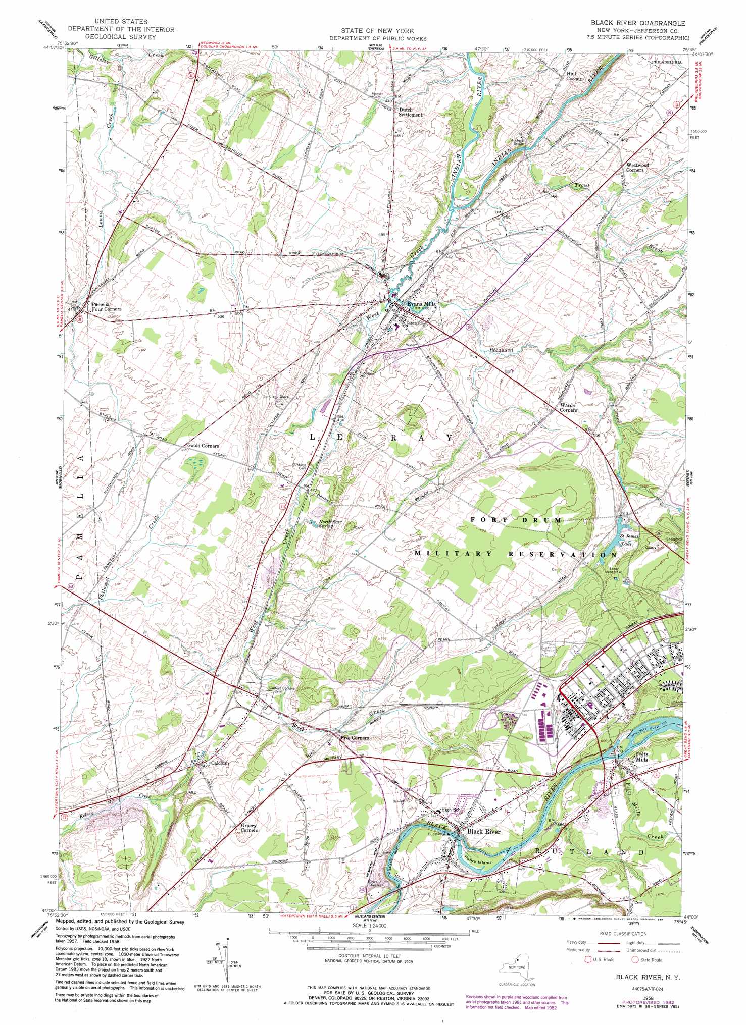
USGS Topo Quad 44075a7 - 1:24,000 scale
| Topo Map Name: | Black River |
| USGS Topo Quad ID: | 44075a7 |
| Print Size: | ca. 21 1/4" wide x 27" high |
| Southeast Coordinates: | 44° N latitude / 75.75° W longitude |
| Map Center Coordinates: | 44.0625° N latitude / 75.8125° W longitude |
| U.S. State: | NY |
| Filename: | o44075a7.jpg |
| Download Map JPG Image: | Black River topo map 1:24,000 scale |
| Map Type: | Topographic |
| Topo Series: | 7.5´ |
| Map Scale: | 1:24,000 |
| Source of Map Images: | United States Geological Survey (USGS) |
| Alternate Map Versions: |
Black River NY 1948 Download PDF Buy paper map Black River NY 1958, updated 1960 Download PDF Buy paper map Black River NY 1958, updated 1960 Download PDF Buy paper map Black River NY 1958, updated 1983 Download PDF Buy paper map Black River NY 1958, updated 1989 Download PDF Buy paper map Black River NY 2010 Download PDF Buy paper map Black River NY 2013 Download PDF Buy paper map Black River NY 2016 Download PDF Buy paper map |
1:24,000 Topo Quads surrounding Black River
Thousand Island Park |
Alexandria Bay |
Redwood |
Muskellunge Lake |
Natural Dam |
Clayton |
La Fargeville |
Theresa |
Philadelphia |
Antwerp |
Dexter |
Brownville |
Black River |
Deferiet |
North Wilna |
Sackets Harbor |
Watertown |
Rutland Center |
Copenhagen |
Carthage |
Adams |
Rodman |
Barnes Corners |
New Boston |
West Lowville |
> Back to 44075a1 at 1:100,000 scale
> Back to 44074a1 at 1:250,000 scale
> Back to U.S. Topo Maps home
Black River topo map: Gazetteer
Black River: Bridges
Anstead Bridge elevation 118m 387′Black River: Islands
Poors Island elevation 171m 561′Black River: Lakes
Saint James Lake elevation 154m 505′Black River: Populated Places
Black River elevation 174m 570′Calcium elevation 143m 469′
Dutch Settlement elevation 134m 439′
Evans Mills elevation 129m 423′
Felts Mills elevation 178m 583′
Sanfords Four Corners elevation 150m 492′
Black River: Springs
North Star Spring elevation 137m 449′Black River: Streams
Felts Mills Creek elevation 171m 561′Lowell Creek elevation 106m 347′
Pleasant Creek elevation 122m 400′
Trout Brook elevation 119m 390′
West Creek elevation 119m 390′
Black River digital topo map on disk
Buy this Black River topo map showing relief, roads, GPS coordinates and other geographical features, as a high-resolution digital map file on DVD:
New York, Vermont, Connecticut & Western Massachusetts
Buy digital topo maps: New York, Vermont, Connecticut & Western Massachusetts